
The Broomway facts for kids
The Broomway is a special public path in Essex, England. It crosses the wide, flat sandy area called the foreshore at Maplin Sands. When the sea goes out, this path lets people reach Foulness Island. For a long time, it was the only way to get to the island on foot when the tide was low. A road bridge was built in 1922, which made access much easier.
This ancient path is over 600 years old, first mentioned in 1419! The Broomway stretches for about 6 miles (10 km) across the Maplin Sands, staying about 440 yards (400 m) from the current shoreline. It got its name from the "brooms" – bundles of twigs on short poles – that used to mark the way. The path can be very dangerous, especially when it's foggy. The tide comes in very fast, and the water can form swirling whirlpools from the River Crouch and River Roach. In bad weather, it's easy to get lost and not know which way the shore is.
Contents
Journey Through Time: The Broomway's Past

People have different ideas about how The Broomway started. Some think it's a natural path, just following a ridge of firmer sand. Others believe it was partly or completely built by people. There are signs of Roman settlements on Foulness Island, which makes some wonder if the path was once a Roman road. It might have served farms that later got flooded by the sea. Another idea is that it was an Anglo-Saxon route for moving animals, which also got covered by water but was kept open by local knowledge. An archaeological study found that one part of the Broomway was even strengthened with wooden hurdles at some point.
The Broomway was first written about in 1419. Later, in the 1500s, a writer named William Harrison mentioned it, saying a person could ride to Foulness "if he be skilful of the causie [causeway]". A map from 1595 by John Norden showed the Broomway looking very much like it does today.
In the 1700s, people tried to make the path better because it was the main way for farmers to take their crops to market from the island. In the mid-1800s, money was raised to fix Wakering Stairs, which was an important starting point for the path on the mainland side.
How the Broomway Got its Name
The Broomway used to be marked by special markers that looked like short-handled brooms. These "brooms" were pushed two feet into the sand and stuck out about a foot above it. They were placed about 30 yards apart and held steady with wire. An author named Herbert W. Tompkins, who walked the Broomway in the early 1900s, described how the brooms would "lift their heads and appear as a line of black dots" as the tide went out. This helped travelers know when they could start their journey.
The "brooms" needed to be fixed and replaced often because of the tides and storms. Since at least the 1700s, the local church and the island's main landowner shared the cost of this upkeep. The paths leading from the Broomway to the shore, called "headways," were marked with signposts, just like those on regular roads. At night, when the brooms were hard to see, local people used the lights from faraway ships and the Maplin lighthouse to help them find their way.
The Broomway was a very important link to Foulness Island until the 1900s. In 1901, an author named Reginald A. Beckett described a "curious sight" he saw: "a procession of market-carts coming from Foulness and rapidly driven across the sands, through water about a foot deep." This shows how busy and vital the path was.
Why is the Broomway So Dangerous?

The Broomway is often compared to another risky path across Morecambe Bay. It's known as "the most perilous byway in England." This is because it's very easy to get lost in fog, and if you're still on the sands when the tide rushes in, you could drown. Many people have sadly lost their lives here over the years.
In 1867, a historian named Philip Benton wrote about the dangers for those without a guide. He said some farmers would wait until the last minute, then race the tide and swim across the creeks. Even people who had used the sands their whole lives sometimes died there. Benton himself got lost in the fog while hunting and was only saved by "timely assistance." Besides the fast tide and fog, there were also many "holes" in the mud away from the main path where travelers could get stuck.
Even experienced locals faced risks. In March 1917, a leading farmer from the island drowned one evening while returning from Rochford Market. Records show that 66 bodies have been found on the sands since 1600, and perhaps over 100 people have drowned in total. Because of these dangers, experts advise that you should only walk the Broomway with a local guide.
Finding Your Way on the Broomway

The Broomway starts on the mainland at Wakering Stairs. Here, there's a raised path over a soft muddy area called the Black Grounds, which leads to the firmer Maplin Sands. Once on the sands, the Broomway heads towards a navigation beacon known as "the Maypole." This beacon marks the entrance to Havengore Creek. In the past, travelers also had to wade across New England Creek and Shelford Creek, but these were dammed in the 1920s. From the Maypole, the path turns more to the north, leading to Asplins Head, which is one of the paths still used to get onto Foulness Island. The walk from Wakering Stairs to Asplins Head takes about an hour.
Since the road bridge to the island opened and the "brooms" were no longer kept up, the Broomway is mostly unmarked today. There isn't a clear track. For most of its six-mile route, the Broomway is just a compass direction across the Maplin Sands.
Access Points to the Shore
The "headways," or access points that led from the Broomway to farms along the shoreline, were usually made of stone or gravel. While some are still shown on maps, most are now impossible to use. Here are some of the main headways from south to north:
- Suttons Head or Kennets Head: Near Shoeburyness East Beach, no longer used after 1867.
- King's Head: Near Pig's Bay, also lost.
- Wakering Stairs: This is the current main access point.
- Havengore Island: Three former headways were here, including Havengore Head.
- New England Island: Now lost.
- Shelford Head: Now lost.
- New Burwood Head: Now lost.
- Asplins Head: Still an access point.
- Rugwood Head: Now impassable.
- Eastwick or Pattisons Head: Another access point.
- Fishermans Head: This one is still sometimes used by the military. Its concrete surface is the only way to bring heavy loads onto the island.
From Rugwood Head to Fishermans Head, the Broomway is officially a bridleway (a path for horses and walkers) rather than a byway (a path for all traffic).
It's important to know that access to the Broomway is limited. Both the mainland at Wakering Stairs and Foulness Island itself are used for military purposes.
Images for kids
-
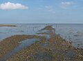
The headway at Wakering Stairs, the current southerly starting point of the Broomway

