
The Steeples facts for kids
Quick facts for kids The Steeples |
|
|---|---|

The Steeples
|
|
| Highest point | |
| Elevation | 2,804 m (9,199 ft) |
| Prominence | 609 m (1,998 ft) |
| Parent peak | Mount Fisher (2843 m) |
| Geography | |

The Steeples
Location in British Columbia

The Steeples
Location in Canada
|
|
| Location | British Columbia, Canada |
| Parent range | Hughes Range Canadian Rockies |
| Topo map | NTS 82G11 |
| Climbing | |
| Easiest route | Scrambling |
The Steeples is a tall mountain ridge in the Canadian Rockies in British Columbia, Canada. It stands about 2,843 meters (9,327 feet) high. This mountain is part of the Hughes Range. It is easy to see from the Crowsnest Highway and the city of Cranbrook. The Steeples is a long ridge, about five kilometers long. Its closest taller neighbor is Mount Fisher.
Contents
The Story Behind the Name
How The Steeples Got Its Name
The Steeples got its name a long time ago, in August 1858. A man named Thomas Blakiston named it. He was part of a group called the Palliser Expedition. They were exploring the area. Thomas Blakiston thought the mountain looked like the tall, pointy tops of churches, which are called steeples.
When the Name Became Official
The name "The Steeples" was officially accepted in 1950. This happened when the Geographical Names Board of Canada approved it. This board makes sure all places in Canada have official names.
Mountain Weather and Water
What the Climate is Like
The Steeples has a subarctic climate. This means it has very cold winters with lots of snow. The summers are mild, not too hot. Temperatures can drop below -20 degrees Celsius. With the wind, it can feel even colder, sometimes below -30 degrees Celsius.
Where the Water Goes
When snow melts or rain falls on the mountain, the water flows down. This water goes into small streams. These streams then join larger rivers. Eventually, the water from The Steeples flows into the Kootenay River.
Images for kids
-
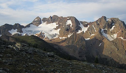
The eastern slope of The Steeples supports a small glacier
-
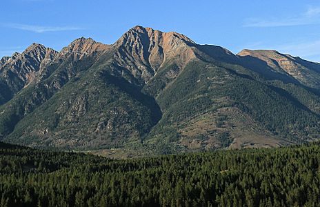
Bull Mountain forms the south end of The Steeples


