The Towans facts for kids
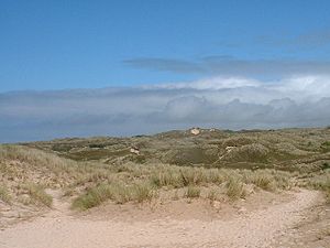
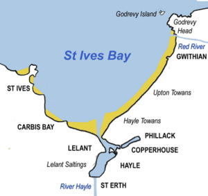
Have you ever wondered about the amazing sand dunes along the coast of Cornwall? In Cornwall, a "Towan" (from the Cornish word Tewyn) means "sand dune." But when people talk about The Towans, they usually mean a special three-mile (5 km) stretch of coastal sand dunes. This area goes from the River Hayle estuary all the way to Gwithian beach. It's a really cool place with lots of history, nature, and even some secrets!
Contents
Exploring The Towans' Geography
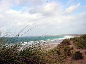
The Towans are a long stretch of sand dunes in Cornwall. To the south-east, they are next to Phillack village and a main road. To the north-west, these dunes face St Ives Bay and its wide beach.
Some parts of The Towans rise quite high, more than 50 meters (164 feet) above sea level! The very highest point is 72 meters (236 feet) at Phillack Towans. The southern part of The Towans is in the Hayle area, and the northern part is in the Gwinear-Gwithian area.
Even though it's all called 'The Towans', different parts have their own names. These names help people know exactly where they are. From south-west to north-east, you'll find:
- Lelant Towans
- Hayle Towans
- Riviere Towans
- Mexico Towans
- Common Towans
- Phillack Towans
- Upton Towans
- Gwithian Towans
Nature and Wildlife at The Towans
A big part of The Towans is a special protected area called the Gwithian to Mexico Towans SSSI. SSSI stands for Site of Special Scientific Interest. This means the area is important for both its unique rocks and its amazing plants and animals.
Two sections of this SSSI are also Local Nature Reserves. This gives them even more protection. For example, Upton Towans is owned by the Cornwall Wildlife Trust. This area has sand dunes and grasslands, which are perfect homes for many different creatures and plants. You might spot beautiful pyramidal orchids, glowing glow worms, pretty silver-studded blue butterflies, and singing skylarks.
In the Gwithian Towans Local Nature Reserve, you can also find skylarks and even adders (a type of snake). It's a great place to see nature up close!
The Towans' Past
The Towans have a long and interesting history. People have lived and worked here for many years.
Ancient Discoveries
At Gwithian Towans, archaeologists found the site of a Bronze Age farm. This farm was active a very long time ago, but today, you can't see any remains of it on the surface.
Stories from the Past
Upton Towans was once known as Great Towan. There was a farm there called Upton Barton. One night, after 1650, a huge sand dune collapsed and buried the farmhouse! Luckily, the people living there escaped through the top windows. The remains of this farm haven't been seen since the winter of 1808–09.
In 1879, a local reverend helped unemployed men by creating a new farming area of about 9 acres. Much of The Towans was already used for grazing animals.
Mining History
The Towans area was once home to several small mines. Miners dug for valuable metals like tin, copper, and lead.
One mine was called Wheal Lucy. It was abandoned because the miners didn't have enough money to buy a special engine to help them. Later, a new company tried to reopen it, spending a lot of money on machinery. They managed to sell some tin, but the mine eventually closed again.
Another mine, Wheal Dream, was active as early as 1770. It's believed to be the same as Loggans Mine, which was known for its lead.
On Upton Towans, there was Boiling Well Mine. It closed in 1815 but reopened a few years later as Wheal Boil. This mine had problems with flooding, and its engine couldn't pump out all the water. It changed hands and names several times, producing copper, lead, and silver. Today, part of this old mine site is a caravan park.
Near Gwithian, Wheal Emily reopened in 1857 and produced copper and lead. However, it closed a few years later, losing a lot of money.
The Dynamite Works
Upton Towans is also famous for being the site of the National Explosives Works. People locally called it the "Dynamite Works." It was built in 1888 to make explosives for the local mines.
To keep things safe, the dunes were flattened, and small, separate buildings were created for making the explosives. This design helped stop a chain reaction if one building exploded. Even today, you can still see these overgrown enclosures and the old railway tracks that connected them.
Once, an explosion happened in the nitroglycerine plant. It was so powerful that it broke windows in St Ives and was even heard far away on Dartmoor! During the First World War, about 1,800 people worked here, making cordite for the Royal Navy. The factory closed in 1920, but explosives were stored there until the 1960s. Now, this historic site is part of the Upton Towans Nature Reserve.
Power Lines Across the Dunes
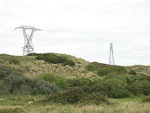
In 1910, a power station was built near the mouth of the River Hayle. This station used coal to make electricity. It operated until 1973. The buildings were taken down, but you can still see its legacy: the tall power lines that stretch across the dunes, especially in the southern part of The Towans.
Folklore of The Towans
There's an old story that says when a big storm hits, you can sometimes see the towers of a castle belonging to Theodoric. He was once a king of Cornwall, known for executing an Irish saint in the 5th century.
 | Aurelia Browder |
 | Nannie Helen Burroughs |
 | Michelle Alexander |


