Thompson Pond (Massachusetts) facts for kids
Quick facts for kids Thompson Pond |
|
|---|---|

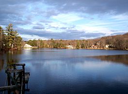
From the 4-H Campsite
|
|
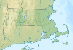
| Location | Spencer, Massachusetts, United States |
| Coordinates | 42°18′09″N 71°58′17″W / 42.30250°N 71.97139°W |
| Type | Pond |
| Catchment area | 18 mi² (46.62 km²) |
| Basin countries | United States |
| Surface area | 116 acres (47 ha) |
| Average depth | 8 ft (2.4 m) |
| Max. depth | 21 ft (6.4 m) |
| Shore length1 | 3.3 mi (5.3 km) |
| Surface elevation | 860 ft (260 m) |
| Settlements | Spencer, Paxton |
| 1 Shore length is not a well-defined measure. | |
Thompson Pond is a beautiful freshwater pond located in central Massachusetts, USA. It's found near the towns of Spencer and Paxton. This pond is an important part of the Chicopee River Watershed, which is like a big area of land where all the water drains into the Chicopee River.
How Thompson Pond Was Formed
Thompson Pond gets its water from a few different places. Turkey Hill Brook starts at Turkey Hill Pond and flows into Eames Pond. Then, it joins Caruth Brook to create Thompson Pond. This brook eventually flows into the Seven Mile River. Long ago, this creek had seven small dams on it!
Thompson Pond covers about 116 acres (which is about 0.47 square kilometers). The pond is held in place by an earthen dam. This dam is about 150 feet (46 meters) long and has a concrete spillway that is 50 feet (15 meters) long. Caruth Brook also brings water from large wetland areas north and west of the pond.
Fun Facts About the Pond
Thompson Pond is located inside the Spencer State Forest reservation. This means it's part of a protected natural area.
The Worcester County 4-H Club has a summer camp called Camp Marshall right on the pond's shores. Camp Marshall was first built in the 1930s by the Civilian Conservation Corps (CCC). The CCC was a program that helped young men find work during the Great Depression by building parks and other public projects. In 1948, the state allowed the 4-H Club to use the site for their summer camp.
Fishing at Thompson Pond
Thompson Pond is a great spot for fishing! It's home to many different kinds of warm water fish. A survey done in 1994 found thirteen different species living there.
Some of the fish you might catch include:
- Large and Small-mouth Bass
- Chain Pickerel
- Yellow Perch
- White Perch
- Black Crappie
- Bluegill
- Pumpkinseed
- Brown and Yellow Bullhead
- Golden Shiner
- Sucker
 | William Lucy |
 | Charles Hayes |
 | Cleveland Robinson |


