
Thornlie, Western Australia facts for kids
Quick facts for kids ThornliePerth, Western Australia |
|||||||||||||||
|---|---|---|---|---|---|---|---|---|---|---|---|---|---|---|---|

Thornlie Square shopping centre
|
|||||||||||||||
| Established | 1956 | ||||||||||||||
| Postcode(s) | 6108 | ||||||||||||||
| Area | 11.6 km2 (4.5 sq mi) | ||||||||||||||
| Location | 15 km (9 mi) SSE of the Perth CBD | ||||||||||||||
| LGA(s) | City of Gosnells | ||||||||||||||
| State electorate(s) | Gosnells, Cannington, Southern River | ||||||||||||||
| Federal Division(s) | Burt | ||||||||||||||
|
|||||||||||||||
Thornlie is a big residential area, or suburb, in Perth, which is the main city of Western Australia. It's about 15 kilometers (9 miles) south-east of Perth's city center. Thornlie is part of the City of Gosnells local government area. The Canning River flows through the northern part of the suburb. Since the 1950s, Thornlie has grown in different stages, with new housing areas being built over time.
Contents
Thornlie's Past
Early Days and First Settlers
The land that is now Thornlie was first settled by Captain Peter Pégus in 1829. He called his land "Coleraine." Before this, the area was used by the native Noongar people. In 1834, Captain Pégus's home and belongings were destroyed in a fire. This event led to the end of his settlement there.
The name Thornlie comes from a farm called "Thornlie Park." This farm was started in 1884 by Frank and Amy James. Amy was the niece of Walter Padbury, who helped pay for the property.
How Thornlie Became a Suburb
The James family sold their dairy farm in 1937 to a man named Nat Harper. When Harper passed away in 1954, the large Thornlie estate, which was about 694 hectares (1,715 acres), was put up for sale.
In 1956, a part of the land was bought by D. and M. O'Sullivan. The Gosnells Roads Board then approved plans to build houses there. By March 1957, forty houses were finished. By May 1958, 100 homes were occupied. This is how Thornlie officially became a residential suburb in the late 1950s. It was designed for middle-income families and people who wanted to move out of the inner city.
The first homes in Thornlie were built in the 1950s and early 1960s. These were located north of Thornlie Avenue and Spencer Road. More homes were built in the 1960s and 1970s south of Thornlie Avenue, near the Canning River. Many blocks of land in Thornlie are quite large, around 700 to 900 square meters. This is why Thornlie is often called one of Perth's "leafy suburbs," meaning it has lots of trees and green spaces.
Growing with New Estates
In the 1970s, the more modern Crestwood Estate was built in southern Thornlie. This estate was special because it tried to offer many services and facilities to homeowners in one place. Later, in the 1980s, the Castle Glen and Forest Lakes housing estates were developed. These new areas focused on providing affordable homes for young families buying their first houses.
Some rural land in the western part of Thornlie, once used for horses and chickens, was developed into homes in the early 2000s. There used to be some factories in the north-western area. The last one, an Inghams chicken factory, closed around 2004. That site was then turned into a residential area too.
What Thornlie Offers

Thornlie is mainly a dormitory suburb. This means many people who live there travel to other areas for work. It has good transport links to other parts of Perth. Albany Highway connects Thornlie to the city center. The Roe Highway links it to the wider road network.
Thornlie is also home to the end of the Thornlie line, which is a train line branching off the Armadale line. There are many bus services that connect to Thornlie railway station. For example, the frequent route 930 goes to Elizabeth Quay bus station. Other bus routes connect Thornlie Station to places like Gosnells railway station (routes 210 and 211) and Cannington railway station (route 206). In the future, Thornlie Station will be updated as part of the Metronet project. This means it will no longer be the end of the Thornlie line.
For shopping, Thornlie has local centers like Thornlie Square Shopping Centre (built in the 1970s) and the Forest Lakes Forum (built in the 1990s). There are also many sports facilities for everyone to use. These include places for lawn bowls, tennis courts, a skate park, a swimming pool, gyms, and ovals for cricket and football. Baseball Park, built in 2007, is where the Perth Heat baseball team plays.
Thornlie Community
Thornlie has two local newspapers that come out every two weeks: the Comment News and the Gosnells Examiner. There is also a local radio station, 107.3 Heritage FM, run by volunteers for Thornlie and the whole City of Gosnells. The community also has annual events like the Safe City awards, which celebrate good things happening in the community.
Who Lives in Thornlie
A large number of Thornlie residents (39.4%) were born outside Australia. This is higher than the average for Perth (31.3%) and Australia (27%). Many residents were born in England (11.3%), New Zealand (3%), Malaysia, India, and Scotland. About 14% of people speak a language other than English at home.
The number of people without jobs (3.4%) is lower than the average for the region (3.7%). Thornlie also has less socio-economic disadvantage than the City of Gosnells as a whole. When it comes to weekly household incomes, Thornlie has fewer very low or very high-income households compared to the Perth average.
The main religions in Thornlie are Catholicism (22.4%) and Anglicanism (19.5%). Other religions include Islam (4.6%) and Buddhism (3.5%). Since 2001, the number of Catholics and Anglicans has slightly decreased, while the number of Muslims has increased. By 2002, Thornlie had the largest Muslim population in Perth.
Crestwood Estate: A Special Place
Thornlie is home to Crestwood Estate, which is a famous example of a successful housing development. It used special design ideas called Radburn design principles. The original architect for Radburn designs, Clarence Stein, reportedly called Crestwood the "first perfect Radburn scheme in the world." From 1973 to 1976, Crestwood was recognized both in Australia and around the world.
While many other areas in Australia used Radburn ideas, Crestwood is one of the few that has kept its original design. This makes it a very important example of modern urban design from the 1970s.
How Crestwood Was Planned
Crestwood was based on the ideas of Paul Ritter, who was the first city planner for Perth. Ritter believed that "it takes a village to raise a child." He gave talks about creating new urban areas that would meet the needs of families and communities. Property developer Ron Sloan was inspired by Ritter's ideas. Together, Sloan, Ritter, and planner Hugh Reynolds designed Crestwood Estate with very specific goals.
Crestwood was meant to be as efficient and affordable as a normal housing area. It would have the same number of homes per acre but with 8% more open green space. Every house was designed to face a park, and roads were made to keep car speeds low. Play areas were easy to watch over, and walking paths were separate from car roads. Each house had a unique design, some chosen through a competition. The outdoor areas were designed by famous landscape architect John Oldham.
Why the Plan Changed
Originally, Crestwood was planned to be much larger, about five times its actual size. It was supposed to have a big pool complex and recreational areas. However, land values dropped in the early 1970s, which made it hard to sell the land. This caused big financial losses for Ron Sloan. Also, the City of Gosnells opposed the idea of more subdivisions like Crestwood because they didn't want to pay for their upkeep.
Because of these problems, Sloan stopped building with the original design. The remaining land was later used for more traditional housing areas, Forest Lakes and Castle Glen Estates, in the 1980s and 1990s.
Even though it wasn't fully built, Crestwood's importance was recognized. In 1973, the developer won an award for urban development. In 1975, the Australian government's Minister for Urban Planning visited the site. He later used similar ideas for three projects in Canberra. Many other experts and academics visited Crestwood throughout the 1970s to learn from its design.
Getting Around Thornlie
Bus Services
- Route 204: From Maddington Station to Murdoch University. Travels along Burslem Drive and Warton Road.
- Route 205: From Maddington Station to Murdoch University. Travels along Burslem Drive, Warton Road, Bluegum Road, and Forest Crescent.
- Route 206: From Cannington Station to Murdoch University. Travels along Spencer Road, Thornlie Station, Yale Road, Storey Road, Berehaven Avenue, Towncentre Drive, Sugarwood Drive, and Garden Street.
- Route 207: From Thornlie Station to Murdoch University. Travels along Spencer Road and Yale Road.
- Route 208: From Cannington Station to Murdoch Station. Travels along Nicholson Road.
- Routes 210 and 211: From Thornlie Station to Gosnells Station. Travels along Spencer Road and Corfield Street.
- Route 212: From Thornlie Station to Canning Vale. Travels along Spencer Road, Hume Road, Lachlan Road, Ovens Road, and Forest Lakes Drive.
- Route 223: A local Thornlie loop from Thornlie Station. Travels along Spencer Road, Yale Road, Storey Road, Berehaven Avenue, Towncentre Drive, Forest Lakes Drive, Hickory Drive, and Bluegum Road.
- Route 228: From Thornlie Station to Gosnells Station. Travels along Spencer Road, Spring Road, Thornlie Avenue, Culross Avenue, Connemara Drive, Tullamore Avenue, Bardwell Street, and Burslem Drive.
- Route 230: From Thornlie Station to Perth Busport. Only serves Thornlie Station.
- Route 517: From Thornlie Station to Murdoch TAFE. Travels along Spencer Road and Warton Road.
- Route 930: A frequent service from Thornlie Station to Elizabeth Quay Bus Station. Travels along Spencer Road.
Train Services
- Thornlie Line
- Thornlie Station
Gallery
-
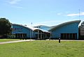
Thornlie Leisure Centre
-
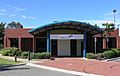
Thornlie Library
-
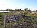
Tom Bateman Reserve
-
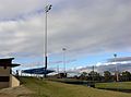
Baseball Park


