Canning Vale, Western Australia facts for kids
Quick facts for kids Canning ValePerth, Western Australia |
|||||||||||||||
|---|---|---|---|---|---|---|---|---|---|---|---|---|---|---|---|

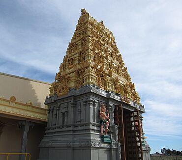
Perth Shiva Temple an iconic place of worship which is popular in Canning Vale
|
|||||||||||||||
| Established | 1980s | ||||||||||||||
| Postcode(s) | 6155 | ||||||||||||||
| Area | 25.3 km2 (9.8 sq mi) | ||||||||||||||
| Location | 22 km (14 mi) from Perth | ||||||||||||||
| LGA(s) |
|
||||||||||||||
| State electorate(s) | Jandakot, Southern River | ||||||||||||||
| Federal Division(s) | Tangney | ||||||||||||||
|
|||||||||||||||
Canning Vale is a suburb located south of Perth, a big city in Western Australia. It's about 22 kilometers (13.7 miles) away from Perth's city center. This area is managed by two local councils: the City of Canning and the City of Gosnells, depending on which part of Canning Vale you are in.
Contents
Exploring Canning Vale's Past
How Canning Vale Got Its Name
Canning Vale is named after the Canning River. This river is about 3 kilometers (1.8 miles) northeast of the suburb. Before 1925, people often called this area North Jandakot.
From Farms to Homes: Canning Vale's Growth
Until the late 1970s, Canning Vale was mostly a farming area. It had many market gardens and dairy farms. This was because the land was quite swampy and had a lot of fresh water. Most of the land that is now covered with houses was originally set aside for rural use until 1994.
There were also plans for future train stations in the area. These stations, called Nicholson Road and Ranford Road, were planned near Nicholson and Ranford roads.
Understanding Canning Vale's Layout
Where is Canning Vale Located?
Canning Vale has clear boundaries. Warton Road is to its southeast, and Garden Street and Nicholson Road are to its northeast. The Roe Highway forms its northern and northwestern edges. Clifton and Acourt roads are to the southwest.
Different Areas of Canning Vale
Canning Vale is divided into three main parts:
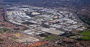
- Industrial Area: North of the train line near Roe Highway, you'll find an industrial zone. This area has large warehouses, including Market City, which is a big market for fresh produce. Many distribution centers, like the Metcash center, are also here. This industrial part used to have major production sites like Swan Brewery (which is now closed) and ACI Packaging. It also has factories for building and mining equipment.
- Residential and Shopping Areas: South of the train line, you'll find homes and places to shop.
- Nature Reserve: The very southern edge of the suburb is a nature reserve. This area also includes some correctional facilities.
The industrial area and some residential parts (like Ranford, Livingston, and Waratah) are in the City of Canning. The rest of the residential area and the correctional facilities are in the City of Gosnells.
Who Lives in Canning Vale?
Canning Vale is a very diverse suburb with people from many different backgrounds.
- 2001 Census: About 12,849 people lived here. Most homes were separate houses. Many residents were from East or South-East Asian backgrounds, and there were also many Indian and Italian people.
- 2006 Census: The population grew to 23,289. Most people were Catholic and married. The average household income was $1,591 per week.
- 2011 Census: The population reached 30,666. The diversity continued, with 15% of residents having Chinese or Indian ancestry. Buddhism and Islam were also common beliefs.
- 2016 Census: The population was 33,059. People with Chinese or Indian ancestry made up 22.4% of the total.
- 2021 Census: The population increased to 35,504. Those with Chinese or Indian ancestry grew to 28.6% of the total population.
Community Life and Facilities
Shopping and Services in Canning Vale
Canning Vale has five main shopping areas. Four of these are in the residential parts of the suburb. There's also a large industrial area in the northwest.
The main shopping center is Livingston Marketplace. It opened in 1997 and was expanded in 2003-2004. You can find it at the corner of Ranford Road and Nicholson Road. Another shopping center, The Vale, is located on the corner of Warton Road and Amherst Road, on the eastern side of Canning Vale.
Schools and Places of Worship
Canning Vale has several schools:
- Primary Schools: Canning Vale (opened 1994), Ranford (1999), Campbell (2002), Excelsior (2005), Caladenia (2007), and the private school St Emilie's Catholic.
- High School: Canning Vale College.
The suburb also has many churches, a Sikh temple, and a Hindu temple. There is also a community center and a golf course called Gosnells Golf Club.
Sports and Clubs
Canning Vale has active sports clubs:
- Junior Football: The Canning Vale Cougars Junior Football Club celebrated its 10th anniversary in 2006. While no AFL players have come from this club, some have gone on to play in the WAFL.
- Cricket: The Canning Vale Junior/Senior Cricket Club is part of the South East Metro Junior Cricket Council.
- Senior Football: The Canning Vale Senior Football Club started in 2011. They play in the WA Amateur Football League and won premierships in 2011, 2012, and 2013. Their home games are played at Clifton Park.
Correctional Facilities
The northern part of Canning Vale, near the Nicholson and Warton Road intersection, includes several correctional facilities. These include Hakea Prison, Melaleuca Remand and Reintegration Facility, and Banksia Hill Juvenile Detention Centre.
Getting Around Canning Vale
Major Roads and Highways
Canning Vale's northern border is the Roe Highway. This highway connects to the Kwinana Freeway (to the west) and Albany Highway (to the east). It also provides access to Perth Airport. Nicholson Road goes north towards Cannington, Western Australia and Westfield Carousel. Ranford Road leads to Armadale (southeast) and Fremantle (northwest) via South Street over the Kwinana Freeway.
Public Transport: Buses and Trains
Canning Vale has many bus services. These buses connect the area to the Perth central business district, Murdoch University, and Cannington. Many bus routes also connect with Transperth trains at Murdoch, Maddington, or Thornlie stations. Two new train stations with bus connections are being built as part of the Thornlie-Cockburn link project.
Bus Routes Serving Canning Vale
- 75: From Canning Vale to Elizabeth Quay Bus Station – travels along Bannister Road.
- 204: From Murdoch University to Maddington Station – uses Ranford Road, Campbell Road, Amherst Road, and Warton Road.
- 205: From Murdoch University to Maddington Station – uses Ranford Road, Campbell Road, Shreeve Road, and Bridge Road.
- 206: From Murdoch University to Cannington Station – uses Ranford Road, Nicholson Road, Dumbarton Road, Boardman Road, and Garden Street.
- 207: From Murdoch University to Thornlie Station – uses Ranford Road, Nicholson Road, and Eucalyptus Boulevard.
- 208: From Murdoch Station to Cannington Station – uses Bannister Road and Nicholson Road.
- 212: From Canning Vale to Thornlie Station – uses Batman Road and Amherst Road.
- 517: From Murdoch TAFE to Thornlie Station – uses Ranford Road.
- 518: From Murdoch TAFE to Cockburn Central Station – uses Ranford Road.
- 519: From Murdoch TAFE to Armadale Station – uses Ranford Road, Southacre Drive, Goodwood Way, Eastwood Parade, Tobermory Pass, and Nicholson Road.
 | Shirley Ann Jackson |
 | Garett Morgan |
 | J. Ernest Wilkins Jr. |
 | Elijah McCoy |


