
Leeming, Western Australia facts for kids
Quick facts for kids LeemingPerth, Western Australia |
|||||||||||||||
|---|---|---|---|---|---|---|---|---|---|---|---|---|---|---|---|

Leeming recreation centre entrance
|
|||||||||||||||
| Postcode(s) | 6149 | ||||||||||||||
| Area | 7.5 km2 (2.9 sq mi) | ||||||||||||||
| Location | 17 km (11 mi) from Perth | ||||||||||||||
| LGA(s) | City of Melville City of Cockburn City of Canning |
||||||||||||||
| State electorate(s) | Jandakot, Riverton | ||||||||||||||
| Federal Division(s) | Tangney | ||||||||||||||
|
|||||||||||||||
Leeming is a friendly suburb located south of Perth, a big city in Western Australia. It's like a puzzle piece shared by three different local councils: the City of Melville, the City of Cockburn (in the south), and the City of Canning (in the north-east). Leeming is about 17 kilometers (10.5 miles) south of Perth's city center and 13 kilometers (8 miles) east of Fremantle, a historic port city.
Contents
Leeming's Past: From Farms to Homes
This area was once part of Jandakot. For a long time, it was mostly farmland, right up until the 1970s. A surveyor named George Waters Leeming (who lived from 1857 to 1902) first mapped out the area in 1886.
Back then, only three main roads led into the area: King Road, Leeming Road (which was the southern border), and Beasley Road. The suburb of Leeming officially got its name in 1971. However, building houses didn't really start until around 1975 or 1976.
The suburb was built in different stages. The first part to be built was the area between Findlay Road and Gracechurch Crescent. After that, the eastern, western, and southern parts were built over the next ten years. Many of the streets in Leeming are named after the original farmers who owned land in this agricultural district.
Where is Leeming? Its Location and Nature
Leeming has clear boundaries. South Street is to the north, the Kwinana Freeway is to the west, and Roe Highway is to the south and southeast. These major roads help people get around and define the suburb's edges.
Within Leeming, you'll find Ken Hurst Park. This is a large, 53-hectare (131-acre) bushland area that is protected for nature. It's named after Ken Hurst, who was a mayor of Melville from 1971 to 1973. This park was set aside in the early 1990s to protect the local plants and animals.
In 2001, a survey showed that Leeming was home to 12,977 people. Most of them lived in 3,959 detached houses, which are houses on their own separate plots of land. About 10% of the people living in Leeming have family roots in East or South-East Asia. Many adults in Leeming work in retail (shops) or in property and business services.
Places to Learn, Shop, and Play in Leeming
Leeming has many useful facilities for its residents.
Learning and Schools
Leeming is a great place for students. It has three primary schools for younger kids:
- Leeming Primary School, opened in 1982
- West Leeming Primary School, opened in 1986
- Banksia Park Primary School, opened in 1989
For older students, there's Leeming Senior High School, which opened in 1985. This high school also has a special education support center to help students with different learning needs.
Shopping and Services
You can find two main shopping centers in Leeming for your everyday needs:
- Leeming Shopping Forum: This is located at the corner of Farrington and Findlay Roads. It has an IGA supermarket, various small shops, and restaurants.
- Leeming Park Shopping Centre: You'll find this center at the corner of Beasley Road and Dundee Street.
If you need more shopping options, larger commercial centers are nearby. Stockland in Bull Creek is just north of Leeming, and Southlands Boulevarde in Willetton is also close by.
Fun and Community Activities
Leeming offers many places for recreation and community gatherings:
- A family center, where families can meet and enjoy activities.
- A recreation center and sports facilities, often called "The Rec," which is a great place for sports and exercise.
- The Leeming Spartan Cricket Club, for cricket fans.
- The Leeming Bowling Club, for those who enjoy lawn bowls.
- The Melville Glades Golf Club, a place for golf enthusiasts.
Important health and education facilities are also just 2 kilometers (1.2 miles) to the west. These include Murdoch University, Murdoch TAFE (a campus of South Metropolitan TAFE), St John of God Murdoch Hospital, and Fiona Stanley Hospital.
Getting Around: Transport in Leeming
Getting around Leeming and to other parts of Perth is easy. The suburb is very close to Murdoch train station, which opened in 2007. All train and bus services are run by the Public Transport Authority.
Here are some bus routes that serve Leeming:
- Bus 515: Travels from Jandakot to Murdoch Station, serving Aulberry Parade, Farrington Road, and Karel Avenue.
- Bus 516: Travels from Jandakot to Murdoch Station, serving Findlay Road, Farrington Road, and Casserly Drive.
Jandakot Airport is also conveniently located just 2 kilometers (1.2 miles) to the south-east of Leeming.
Images for kids
-
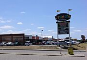
Leeming Shopping Forum on Farrington Road
-
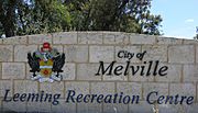
Leeming Recreation Centre sign on Farrington Road
-
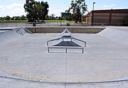
Leeming skate park in 2006. Since 2007, the park has been repainted with street art, under a plan known as "Phaze" organised by the local council.


