Jandakot, Western Australia facts for kids
Quick facts for kids JandakotPerth, Western Australia |
|||||||||||||||
|---|---|---|---|---|---|---|---|---|---|---|---|---|---|---|---|

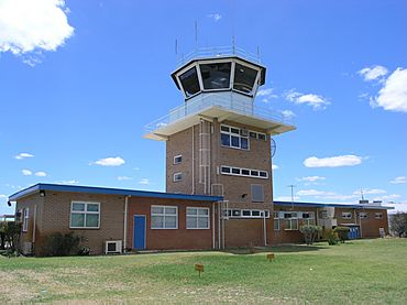
Rear of air traffic control tower, 2006
|
|||||||||||||||
| Postcode(s) | 6164 | ||||||||||||||
| Area | 16.2 km2 (6.3 sq mi) | ||||||||||||||
| Location | 21 km (13 mi) from Perth | ||||||||||||||
| LGA(s) | City of Cockburn | ||||||||||||||
| State electorate(s) | Jandakot | ||||||||||||||
| Federal Division(s) | Fremantle | ||||||||||||||
|
|||||||||||||||
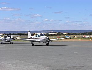
Jandakot is a suburb located south of Perth, Western Australia. It is part of the City of Cockburn area. Jandakot is most famous for its airport, Jandakot Airport, which is entirely within the suburb. This airport is known as Australia's busiest airport for smaller planes and training flights. It is also one of Australia's busiest civilian airports overall.
Contents
History of Jandakot
Jandakot gets its name from Lake Jandakot, which is now called Lake Forrestdale (since 1973). Early maps from the 1830s showed a very large lake south-west of Kelmscott.
In 1833, Septimus Roe, a government surveyor, found that the lake was not as big as first thought. It became a well-known spot for getting water on the old path between the Canning River and Pinjarra. In 1844, a surveyor named J.W. Gregory recorded its Aboriginal name as Jandacot. Over the years, the name was spelled in different ways, but Jandakot was finally chosen. The Aboriginal meaning of the word is said to be "place of the Whistling Eagle."
Where is Jandakot?
Jandakot is bordered by several roads and city limits. To the north, you'll find the Roe Highway. The Kwinana Freeway is to the west. Johnston Road is on the east side. To the south, it's bordered by Fraser Road, Jandakot Road, Solomon Road, and Armadale Road. The north-eastern edge of Jandakot is also the boundary for the City of Melville. The eastern boundary is where the City of Canning begins.
Jandakot Airport
Jandakot Airport is the most famous part of Jandakot. It's a very busy airport used for pilot training and domestic flights. It opened in 1963. There's even a cafe at the airport where you can watch planes take off and land!
There have been ideas to move the airport to a new location far away. However, many people who use the airport do not want it to move. In 2006, the Minister for Transport said that the airport would stay where it is. Plans include making big improvements to the airport's facilities, like adding a new runway.
Green Hydrogen Project
In 2018, the Australian Renewable Energy Agency (ARENA), a government group, gave money to start Australia's first green hydrogen project in Jandakot. This project, called the ATCO Hydrogen Microgrid, was a test by a company named ATCO. They wanted to see if they could make, store, and use clean hydrogen energy to power a small energy system called a microgrid.
The idea was to use solar energy to separate hydrogen from water. This hydrogen was then collected and used in the Clean Energy Innovation Hub (CEIH) in Jandakot. The project cost about A$3.53 million in total and was finished in November 2019. It helped show how green hydrogen could be used for power.
Getting Around Jandakot
Bus Services
Several bus routes serve the Jandakot area:
- Route 233 travels between Cockburn Central Station and Gosnells Station. It uses Beeliar Drive and Armadale Road.
- Route 515 goes from Jandakot to Murdoch Station. It uses Berrigan Drive.
- Route 518 connects Cockburn Central Station to Murdoch TAFE. It also uses Beeliar Drive and Armadale Road.
- Route 523 runs from Cockburn Central Station to Treeby. It uses Beeliar Drive and Armadale Road.
- Route 527 travels from Cockburn Central Station to Aubin Grove Station. It also uses Beeliar Drive and Armadale Road.
Train Services
The Mandurah Train Line serves the area.
- The closest station is Cockburn Central Station.
Climate in Jandakot
Jandakot has a climate typical of the Perth area. This means it has cool, wet winters and hot, dry summers. In summer, temperatures can reach as high as 45 °C (113 °F). Winter temperatures are milder, usually around 15 °C (59 °F).
Jandakot holds the record for the lowest temperature ever recorded in the Perth metro area, which was −3.4 °C (25.9 °F). It often gets below freezing in winter.
| Climate data for Jandakot Airport | |||||||||||||
|---|---|---|---|---|---|---|---|---|---|---|---|---|---|
| Month | Jan | Feb | Mar | Apr | May | Jun | Jul | Aug | Sep | Oct | Nov | Dec | Year |
| Record high °C (°F) | 45.7 (114.3) |
46.6 (115.9) |
43.0 (109.4) |
39.2 (102.6) |
33.4 (92.1) |
25.6 (78.1) |
25.9 (78.6) |
29.4 (84.9) |
34.2 (93.6) |
37.4 (99.3) |
40.3 (104.5) |
44.0 (111.2) |
46.6 (115.9) |
| Mean maximum °C (°F) | 40.3 (104.5) |
40.2 (104.4) |
38.5 (101.3) |
33.5 (92.3) |
28.2 (82.8) |
23.7 (74.7) |
22.3 (72.1) |
24.0 (75.2) |
26.9 (80.4) |
32.2 (90.0) |
36.6 (97.9) |
39.2 (102.6) |
42.0 (107.6) |
| Mean daily maximum °C (°F) | 31.3 (88.3) |
31.6 (88.9) |
29.6 (85.3) |
25.8 (78.4) |
22.0 (71.6) |
19.2 (66.6) |
18.0 (64.4) |
18.7 (65.7) |
20.1 (68.2) |
22.9 (73.2) |
26.5 (79.7) |
29.2 (84.6) |
24.6 (76.3) |
| Mean daily minimum °C (°F) | 16.8 (62.2) |
17.2 (63.0) |
15.6 (60.1) |
12.5 (54.5) |
9.3 (48.7) |
7.6 (45.7) |
6.9 (44.4) |
7.2 (45.0) |
8.2 (46.8) |
9.8 (49.6) |
12.7 (54.9) |
14.8 (58.6) |
11.6 (52.9) |
| Mean minimum °C (°F) | 9.4 (48.9) |
10.3 (50.5) |
7.2 (45.0) |
5.0 (41.0) |
2.5 (36.5) |
1.0 (33.8) |
−0.1 (31.8) |
0.8 (33.4) |
1.6 (34.9) |
3.0 (37.4) |
5.8 (42.4) |
7.9 (46.2) |
−0.9 (30.4) |
| Record low °C (°F) | 4.7 (40.5) |
6.5 (43.7) |
1.6 (34.9) |
2.3 (36.1) |
−0.6 (30.9) |
−3.4 (25.9) |
−2.8 (27.0) |
−1.4 (29.5) |
−1.3 (29.7) |
−1.0 (30.2) |
0.8 (33.4) |
3.2 (37.8) |
−3.4 (25.9) |
| Average rainfall mm (inches) | 16.1 (0.63) |
17.5 (0.69) |
16.4 (0.65) |
41.1 (1.62) |
105.2 (4.14) |
152.4 (6.00) |
173.1 (6.81) |
129.1 (5.08) |
84.2 (3.31) |
46.0 (1.81) |
27.1 (1.07) |
10.6 (0.42) |
819.6 (32.27) |
| Average precipitation days | 2.6 | 2.3 | 3.8 | 7.2 | 12.0 | 15.6 | 17.8 | 15.5 | 13.5 | 9.0 | 6.0 | 3.4 | 108.7 |
| Average afternoon relative humidity (%) (at 15:00) | 37 | 36 | 38 | 45 | 51 | 57 | 58 | 55 | 53 | 48 | 43 | 39 | 47 |
| Source: Bureau of Meteorology Temperatures: 1989–2020; Rain data: 1972–2020; Relative humidity: 1990–2010 |
|||||||||||||
 | William M. Jackson |
 | Juan E. Gilbert |
 | Neil deGrasse Tyson |


