Banjup, Western Australia facts for kids
Quick facts for kids BanjupPerth, Western Australia |
|||||||||||||||
|---|---|---|---|---|---|---|---|---|---|---|---|---|---|---|---|

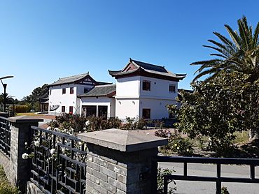
Siheyuan style house in predominantly rural Banjup
|
|||||||||||||||
| Established | 1900s | ||||||||||||||
| Postcode(s) | 6164 | ||||||||||||||
| Area | 22.5 km2 (8.7 sq mi) | ||||||||||||||
| LGA(s) | City of Cockburn | ||||||||||||||
| State electorate(s) | Jandakot | ||||||||||||||
| Federal Division(s) | Fremantle | ||||||||||||||
|
|||||||||||||||
Banjup is a suburb in Perth, Western Australia. It's part of the City of Cockburn. You can find it about 25 kilometers south of the main city center of Perth. The postcode for Banjup is 6164.
Banjup is mostly made up of large properties, often with lots of open space. Many people here have "hobby farms" where they might keep horses. There are also some businesses that grow plants and flowers. People who live here often enjoy the quiet and the extra room compared to typical city homes.
A big part of Banjup is located on something called the Jandakot Water Mound. This is an important area for water. Because of this, there are rules about how many animals you can have on a property. This helps protect the water from getting dirty from things like rainwater washing chemicals from properties.
A large section of the Jandakot Regional Park is also found within Banjup. This park is a great place for nature and outdoor activities.
Contents
Discovering Banjup's Past
The name "Bangup Lake" was first written down in 1889 by a surveyor named James Oxley. It likely came from the Whadjuk Noongar word bangup or bangap, which means quokka (a small marsupial).
The area around the lake started being called "Bangup" in the 1890s. This was after the Jandakot Agricultural Area opened up for people to settle there. In the early 1900s, the spelling changed to Banjupp.
Later, in 1907, a train stop on the Fremantle-Armadale railway line was named Bangup. Then, in the 1930s, the spelling was changed again to what we know today: Banjup.
In 2016, a part of northern Banjup, located above Armadale Road, became a brand new suburb called Treeby.
Banjup Memorial Park: A Place to Remember
Banjup Memorial Park was created after World War I. It's a special place to honor the men from the area who served in the war. For each of the fourteen men who joined up, a gum tree was planted. If a tree dies, a new one is planted in its place.
There's a plaque at the park that lists the names of these men. Another copy of the plaque is kept at the Azelia Ley Homestead. The plaque shows who returned safely, who was wounded, and who sadly died. The Cockburn RSL group helps take care of Banjup Memorial Park.
Out of the 14 men from Banjup who fought in the war, six were killed. Four were wounded, and the other four came back home to Australia. This memorial has the highest percentage of men killed or wounded compared to any other war memorial in Western Australia.
Getting Around Banjup: Transport Options
Banjup has several bus routes that help people travel to nearby areas and train stations.
Bus Routes Serving Banjup
- Route 233: Travels between Cockburn Central Station and Gosnells Station. This bus uses Armadale Road.
- Route 518: Connects Cockburn Central Station to Murdoch TAFE. It also uses Armadale Road.
- Route 523: Goes from Cockburn Central Station to Treeby. This route also runs along Armadale Road.
- Route 527: Travels between Cockburn Central Station and Aubin Grove Station. This bus uses Tapper Road.
- Route 529: Links Cockburn Central Station to Armadale Station. You'll find this bus on Armadale Road.
- Route 537: Runs from Wandi to Aubin Grove Station. This route uses Lyon Road.
Banjup Community Group
The Banjup Residents Group was started in 2010. This group works to speak up for the people living in Banjup. They talk with local, state, and federal governments about issues important to the community. About 45% of the people who live in Banjup are members of this group.
 | James Van Der Zee |
 | Alma Thomas |
 | Ellis Wilson |
 | Margaret Taylor-Burroughs |

