Tizimín facts for kids
Quick facts for kids
Tizimín
|
||
|---|---|---|

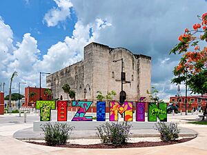
Church of the Three Kings of Tizimín.
|
||
|
||
| Motto(s):
King's City
|
||
| Country | Mexico | |
| State | Yucatán | |
| Municipality | Tizimín Municipality | |
| Elevation | 20 m (70 ft) | |
| Population
(2010)
|
||
| • Total | 46,971 | |
| Demonym(s) | Tizimilean | |
| Postal Code |
97700
|
|
| Prefix | 986 | |
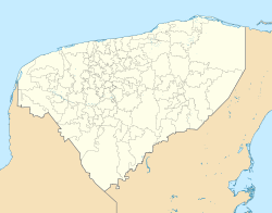
Tizimín is a lively city in the Yucatán state of Mexico. It's part of the Tizimín Municipality and is located near the coast. The city sits about 20 meters (65 feet) above sea level.
Tizimín is famous for its special fair, which celebrates the Three Kings. This fair happens every year in late December and early January. Because of this popular event, Tizimín is often called "King's City". You can also find many beautiful Mexican handicrafts here, like rebozos (shawls), huipils (traditional dresses), tablecloths, jewelry, and guayaberas (men's shirts).
In 2010, Tizimín was the second-largest city in eastern Yucatán by population. It's also a very important center for cattle farming in the state. The city provides many services for the northeastern part of Yucatán.
Contents
Where is Tizimín Located?
Tizimín is quite a distance from Mexico City, about 1,492 kilometers (927 miles) away. It's closer to other important places in Yucatán:
- 167 km (104 miles) from Merida, Yucatan, the state capital.
- 54 km (34 miles) from Rio Lagartos.
- 50 km (31 miles) from Valladolid, Yucatan.
- 36 km (22 miles) from Ek' Balam, an ancient Mayan site.
- 27 km (17 miles) from Espita.
What's the Weather Like?
Tizimín has a warm climate throughout the year. It gets a lot of rain, especially from May to September. The hottest months are usually April and May, while the coolest are December and January. Even in the cooler months, the temperatures are still very pleasant.
| Climate data for Tizimín | |||||||||||||
|---|---|---|---|---|---|---|---|---|---|---|---|---|---|
| Month | Jan | Feb | Mar | Apr | May | Jun | Jul | Aug | Sep | Oct | Nov | Dec | Year |
| Record high °C (°F) | 36.5 (97.7) |
38.0 (100.4) |
41.0 (105.8) |
41.0 (105.8) |
42.0 (107.6) |
40.0 (104.0) |
39.0 (102.2) |
39.5 (103.1) |
41.0 (105.8) |
39.3 (102.7) |
38.0 (100.4) |
35.6 (96.1) |
42.0 (107.6) |
| Mean daily maximum °C (°F) | 28.9 (84.0) |
30.3 (86.5) |
32.2 (90.0) |
34.2 (93.6) |
35.2 (95.4) |
33.8 (92.8) |
33.5 (92.3) |
33.8 (92.8) |
32.9 (91.2) |
31.2 (88.2) |
30.2 (86.4) |
28.9 (84.0) |
32.1 (89.8) |
| Daily mean °C (°F) | 21.9 (71.4) |
22.8 (73.0) |
24.5 (76.1) |
26.2 (79.2) |
27.8 (82.0) |
27.5 (81.5) |
27.1 (80.8) |
27.3 (81.1) |
26.7 (80.1) |
25.3 (77.5) |
23.9 (75.0) |
22.2 (72.0) |
25.3 (77.5) |
| Mean daily minimum °C (°F) | 15.0 (59.0) |
15.2 (59.4) |
16.7 (62.1) |
18.3 (64.9) |
20.4 (68.7) |
21.1 (70.0) |
20.8 (69.4) |
20.8 (69.4) |
20.6 (69.1) |
19.4 (66.9) |
17.7 (63.9) |
15.5 (59.9) |
18.5 (65.3) |
| Record low °C (°F) | 4.0 (39.2) |
4.0 (39.2) |
5.7 (42.3) |
6.5 (43.7) |
13.5 (56.3) |
15.0 (59.0) |
15.5 (59.9) |
17.0 (62.6) |
17.0 (62.6) |
10.0 (50.0) |
7.0 (44.6) |
4.8 (40.6) |
4.0 (39.2) |
| Average precipitation mm (inches) | 49.4 (1.94) |
41.2 (1.62) |
45.7 (1.80) |
59.1 (2.33) |
111.6 (4.39) |
153.1 (6.03) |
210.4 (8.28) |
168.5 (6.63) |
216.5 (8.52) |
127.9 (5.04) |
52.9 (2.08) |
57.4 (2.26) |
1,293.7 (50.93) |
| Average precipitation days (≥ 0.1 mm) | 4.5 | 4.1 | 3.1 | 2.9 | 7.0 | 12.1 | 14.1 | 13.7 | 14.8 | 10.2 | 5.7 | 4.3 | 96.5 |
| Source: Servicio Meteorologico Nacional | |||||||||||||
Sister City Connections
Since 2011, Tizimín has had a special connection with another city far away. This is called a sister city relationship. It helps cities learn from each other and build friendships.
- Tizimín's sister city is Evansville, Indiana in the United States.
| City | Location | Country | Establishment |
|---|---|---|---|
| Evansville | Vanderburgh County, Indiana | 2011 |
Getting Around Tizimín
The city has its own airport, the Cupul National Airport (airport code: TZM). This makes it easier for people to travel to and from Tizimín.
See also
 In Spanish: Tizimín para niños
 | Janet Taylor Pickett |
 | Synthia Saint James |
 | Howardena Pindell |
 | Faith Ringgold |


