Tlaxco, Tlaxcala facts for kids
Quick facts for kids
Tlaxco
|
||
|---|---|---|

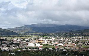
The town and municipal seat of Tlaxco
|
||
|
||

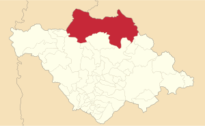
Location in Tlaxcala
|
||
| Country | ||
| State | ||
| Established | 29 August 1945 | |
| Seat | Tlaxco | |
| Area | ||
| • Total | 575 km2 (222 sq mi) | |
| Elevation
(of seat)
|
2,553 m (8,376 ft) | |
| Highest elevation
(Cerro Peñas Coloradas)
|
3,360 m (11,020 ft) | |
| Population
(2010 Census)
|
||
| • Total | 39,939 | |
| • Estimate
(2015 Intercensal Survey)
|
42,536 | |
| • Density | 69.46/km2 (179.90/sq mi) | |
| • Seat | 14,806 | |
| Time zone | UTC-6 (Central) | |
| Postal code of seat |
90250
|
|
| Area code | 241 | |
| Website | Official website: http://tlaxco.gob.mx/ | |
Tlaxco is a town and a surrounding area called a municipality in the Mexican state of Tlaxcala. The name "Tlaxco" comes from the Nahuatl language and means "place of the ball game".
Geography of Tlaxco
Where is Tlaxco Located?
The municipality of Tlaxco is in the northern part of Tlaxcala. It shares borders with the states of Hidalgo and Puebla. To the north, it borders towns like Ixtacamaxtitlán and Chignahuapan in Puebla, and Almoloya and Apan in Hidalgo.
Size and Landscape
Tlaxco is the largest municipality in Tlaxcala. It covers an area of 575 square kilometers. This means it makes up about 14.40% of the entire state.
Tlaxco is located in a high area called the Mexican Altiplano. Its average height is about 2,540 meters (8,333 feet) above sea level. The western and central parts of Tlaxco are mostly flat. However, the northern and eastern parts have more hills and mountains. The highest point is a mountain called Cerro Peñas Coloradas. It stands at 3,360 meters (11,024 feet) tall.
Rivers and Water
The Zahuapan River and its smaller streams flow through the central-eastern part of Tlaxco. There are also two reservoirs, which are like large artificial lakes. These are called Lázaro Cárdenas and El Muerto. A big part of the municipality, about 65%, is used for farming.
Climate in Tlaxco
Tlaxco has a mild, somewhat humid climate. The warmest months are usually from March to May. The most rain falls between June and September. On average, Tlaxco gets between 600 and 900 millimeters (24 to 35 inches) of rain each year.
| Climate data for Tlaxco weather station at 19°35′33″N 98°07′32″W / 19.59250°N 98.12556°W, 2489 m above sea level (1951–2010) | |||||||||||||
|---|---|---|---|---|---|---|---|---|---|---|---|---|---|
| Month | Jan | Feb | Mar | Apr | May | Jun | Jul | Aug | Sep | Oct | Nov | Dec | Year |
| Record high °C (°F) | 30.0 (86.0) |
33.0 (91.4) |
34.0 (93.2) |
36.0 (96.8) |
37.5 (99.5) |
40.0 (104.0) |
30.0 (86.0) |
30.0 (86.0) |
29.0 (84.2) |
30.5 (86.9) |
30.0 (86.0) |
41.0 (105.8) |
41.0 (105.8) |
| Mean daily maximum °C (°F) | 22.0 (71.6) |
23.4 (74.1) |
25.6 (78.1) |
26.4 (79.5) |
25.8 (78.4) |
23.6 (74.5) |
22.6 (72.7) |
22.8 (73.0) |
22.0 (71.6) |
22.0 (71.6) |
22.3 (72.1) |
21.8 (71.2) |
23.4 (74.1) |
| Daily mean °C (°F) | 11.7 (53.1) |
12.8 (55.0) |
14.9 (58.8) |
16.3 (61.3) |
16.5 (61.7) |
16.1 (61.0) |
15.0 (59.0) |
15.0 (59.0) |
14.9 (58.8) |
14.0 (57.2) |
12.9 (55.2) |
11.9 (53.4) |
14.3 (57.7) |
| Mean daily minimum °C (°F) | 1.5 (34.7) |
2.3 (36.1) |
4.3 (39.7) |
6.1 (43.0) |
7.3 (45.1) |
8.5 (47.3) |
7.4 (45.3) |
7.2 (45.0) |
7.8 (46.0) |
5.9 (42.6) |
3.5 (38.3) |
2.1 (35.8) |
5.3 (41.5) |
| Record low °C (°F) | −9.0 (15.8) |
−9.0 (15.8) |
−6.0 (21.2) |
−6.0 (21.2) |
−2.0 (28.4) |
−1.0 (30.2) |
0.0 (32.0) |
0.0 (32.0) |
−3.5 (25.7) |
−8.0 (17.6) |
−9.0 (15.8) |
−8.0 (17.6) |
−9.0 (15.8) |
| Average precipitation mm (inches) | 11.8 (0.46) |
8.9 (0.35) |
13.8 (0.54) |
41.6 (1.64) |
72.0 (2.83) |
127.4 (5.02) |
124.2 (4.89) |
120.9 (4.76) |
110.2 (4.34) |
60.1 (2.37) |
15.0 (0.59) |
6.7 (0.26) |
712.6 (28.06) |
| Average precipitation days (≥ 0.1 mm) | 1.8 | 2.2 | 3.3 | 7.5 | 11.1 | 14.6 | 16.2 | 16.0 | 14.5 | 8.0 | 3.3 | 1.8 | 100.3 |
| Source: Servicio Meteorológico Nacional | |||||||||||||
History of Tlaxco
Early Settlements
People have lived in the Tlaxco area for a very long time. Small settlements were found from a period called the Texoloc phase. More permanent settlements began later, during the Tezoquipan phase. These early people were connected to the ancient city of Teotihuacan.
Changes Over Time
Between 650 and 850 AD, the northern part of Tlaxcala had a lot of political changes. Many different groups fought for control. By 900 AD, a group of Huastec or Otomi people became powerful. This led to the creation of the Tlaxco culture.
Modern Tlaxco Begins
Franciscans, who were a type of Christian religious group, arrived in Tlaxco by 1614. At that time, Tlaxco was part of another municipality called Atlangatepec. After 1820, Tlaxco started to become its own separate area within Tlaxcala.
By the late 1800s, Tlaxco was well-known for making pulque, a traditional Mexican drink. A famous Mexican president, Porfirio Díaz, visited Tlaxco in 1894. He opened the municipal palace, which is like the town hall. The modern municipality of Tlaxco was officially created on August 29, 1945. Later, in 1956, a new highway was finished. This road connected Tlaxco to other important towns like Apizaco and Chignahuapan.
Administration
How Tlaxco is Governed
The local government of Tlaxco is made up of a president, a councilor (called a síndico in Spanish), and seven trustees (called regidores). These officials are chosen by the people through elections. The current president of the municipality is Gardenia Hernández Rodríguez.
Population
How Many People Live in Tlaxco?
According to the 2010 Mexican Census, the municipality of Tlaxco had 39,939 people living in about 9,356 homes. In a survey done in 2015, the population had grown to 42,536 people.
Main Towns
There are 155 smaller communities within the municipality. Two of these are considered urban, meaning they are more like cities or larger towns:
- Tlaxco: This is the main town and the center of the municipality. In 2010, it had 14,806 people. In 2015, the Mexican Secretariat of Tourism named Tlaxco a Pueblo Mágico. This means it's a "Magical Town" recognized for its natural beauty, cultural richness, or historical importance.
- San José Atotonilco: This town had 3,220 people in 2010.
Economy
What Do People Do for Work?
The main way people make a living in Tlaxco is through agriculture. This means farming is the most important economic activity in the area.
See also
 In Spanish: Municipio de Tlaxco (Tlaxcala) para niños


