
Tolkien's maps facts for kids
J. R. R. Tolkien's maps show his amazing fictional worlds like Middle-earth. These maps helped him create his stories, guided readers through his adventures, and made his worlds feel incredibly real and deep.
Tolkien once said he started by drawing maps and then built his stories around them. He also wanted his maps to look beautiful, not just be practical. Many fantasy writers today also include maps in their books, following his lead.
His publisher, Allen & Unwin, asked an artist named Pauline Baynes to draw a map of Middle-earth based on Tolkien's ideas. This map became super famous! Later, another publisher, HarperCollins, redrew the maps, but they looked too plain and lost the special hand-drawn feel of Tolkien's originals.
.jpg)
.jpg)
Contents
Maps in Tolkien's Books
The Hobbit Maps
The Hobbit has two simple maps and about 50 place names. One map is "Thror's map," which shows the Lonely Mountain with its entrances and parts of two rivers. It's even decorated with a spider and its web! It also has notes written in runes.
The other map shows "Wilderland", stretching from Rivendell in the west to the Lonely Mountain and Smaug the dragon in the east. The Misty Mountains are drawn to look 3D. Mirkwood is shown with lots of trees, spiders, webs, hills, and villages. Place names are printed in red. Both maps have a thick line on the left side, marked "Edge of the Wild" on the Wilderland map. This line was inspired by the margin on school paper, where you weren't supposed to write!
Tolkien drew and lettered his maps by hand. The publishers later asked for them to be redrawn so they would print better, have sharper letters, and use fewer colors.
The Lord of the Rings Maps


The Lord of the Rings includes three maps and over 600 place names! There's a big map of the north-west of Middle-earth, showing mountains and coastlines. There's also a more detailed map of "A Part of the Shire". The third map is a special contour map by Christopher Tolkien (J.R.R.'s son) of parts of Rohan, Gondor, and Mordor. This one looks very different.
Tolkien worked on the book for many years, using a hand-drawn map of Middle-earth on squared paper. He added many notes in pencil and different inks over time, some of which faded. The paper itself became soft, torn, and yellow from so much use!
His son Christopher drew the contour map from his father's detailed design. The finished map perfectly showed the hills, features, and names from his father's drawing. However, it didn't include the path (with dates) that Frodo and Sam took to destroy the One Ring in Mount Doom. Both father and son worked incredibly hard to finish the map in time for the book to be published. Tolkien wrote:
I had to devote many days, the last three virtually without food or bed, to drawing re-scaling and adjusting a large map, at which [Christopher] then worked for 24 hours (6am to 6am without bed) in re-drawing just in time.
Many places on the maps are never even mentioned in the story! The map of the Shire is the only one that shows political borders, like the divisions between its different areas.
The Silmarillion Maps
The first edition of The Silmarillion has two maps. One is a large, fold-out map of Beleriand. The Ered Luin mountains on its right side match the mountains on the left side of the main map in The Lord of the Rings. The other map is a smaller version of the same area, showing coasts, mountains, and rivers, but no forests. It has the names of Elven leaders printed in red.
Other continents and regions in The Silmarillion aren't mapped in the book. However, Tolkien drew sketches of his world Arda in its early days, including Valinor and the star-shaped island of Numenor. The Numenor map, with its coasts and mountains, was later printed in Unfinished Tales.
Why Maps Are Important
Making the World Feel Real
Tolkien's maps mix artistic ideas with real map-making rules. They have what Tolkien called an "archaic air," meaning they look old-fashioned, but they aren't exactly like medieval maps. For example, he left blank spaces between features, which was a newer idea in the 1700s. This meant that the things drawn on the map were reliable.
Tolkien's map style is like the "Arts and Crafts" movement, which focused on making things both useful and beautiful. His maps are practical but also graceful and pretty. They are somewhere between a picture and a real map.
Tolkien himself said that "there should be picturesque maps, providing more than a mere index to what is said in the text." So, his maps do three main things:
- They help him create a story that makes sense.
- They guide the reader through the story.
- They use their beauty to pull the reader into the imagined world.
From Map to Story

In 1954, Tolkien wrote to another writer, Naomi Mitchison, saying:
I wisely started with a map, and made the story fit (generally with meticulous care for distances). The other way about lands one in confusions and impossibilities, and in any case it is weary work to compose a map from a story — as I fear you have found.
Tolkien didn't just create maps; he also developed names and languages before he even had a full story. For example, he used Old Norse for the Dwarves in The Hobbit and modern English for the Hobbits. His choice of Old English for the riders of Rohan created a "language map" of Middle-earth, showing how different peoples, languages, and regions were connected.
Karen Wynn Fonstad, who wrote The Atlas of Middle-earth, said that in such a detailed world, writing needs a deep understanding of everything. She found, like Tolkien, that she couldn't make her atlas until she understood all the details, like distances, the timeline of the quest, geology, and the land itself.
Making the World Feel Deep
The "lovingly detailed" maps helped shape the stories and made the whole world believable. The names and maps give Middle-earth a feeling of being solid and vast, both in space and time. Readers don't usually study the history of place names like Tolkien did. Instead, they see them as labels that make the places feel real and important, with their own nature and history. This makes maps incredibly useful for fantasy, as they constantly remind you that these places truly exist within the story.
Fantasy Maps Before and After Tolkien
Maps Before Tolkien
In 1897, William Morris's book The Sundering Flood had a map at the beginning. It showed a city on a big river, a "Desert Waste," and towns with English names. This map seems to be the first modern-style fantasy map, showing a completely made-up world. Tolkien said he wanted to copy Morris's style and used ideas from his stories.
Tolkien might also have been inspired by maps in other books, like Jonathan Swift's 1726 Gulliver's Travels and Robert Louis Stevenson's 1883 adventure story Treasure Island.
-
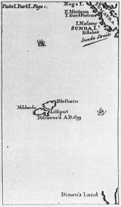
A realistic map: the 1726 Gulliver's Travels showed Lilliput near Sumatra.
-
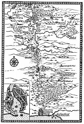
The first modern-style fantasy map: the map at the start of William Morris's 1897 The Sundering Flood.


Tolkien's Influence
Tolkien's maps set a completely new standard for fantasy novels. Because of him, it's now expected for fantasy books to include maps. He basically created the fantasy genre as we know it! Peter Jackson even used Tolkien's Middle-earth map in his Lord of the Rings movies. Many popular fantasy authors today, like George R. R. Martin, use maps in all their books, such as A Song of Ice and Fire.
Other Maps of Middle-earth

The Famous Poster Map
In 1969, Tolkien's publisher asked the artist Pauline Baynes to paint a map of Middle-earth. Tolkien gave her copies of his own map drafts and even added notes to her copy of his son Christopher's 1954 map. The publisher released Baynes's map as a poster in 1970. It was decorated with pictures of Tolkien's characters and small scenes from his stories. This poster map became a symbol of Middle-earth. Tolkien liked her artwork more than any other illustrator's.
Redrawn Maps
When the publishers HarperCollins redrew the maps for a later edition of The Lord of the Rings, they looked "bland, modern, professional." This made them lose the feeling of being old, hand-drawn maps. Tolkien wanted his maps to be accurate, not just decorative. The new maps also lost the charm of Tolkien's own "charming hand lettering," which made them feel like they were old copies made by characters like Bilbo himself.
Fan-Made Maps
Fans of Tolkien's world have also created many detailed maps. Some have even published their works, like Karen Wynn Fonstad's The Atlas of Middle-earth.
|
