
Geography of Tonga facts for kids
 |
|
| Continent | Pacific Ocean |
|---|---|
| Region | Oceania |
| Coordinates | 20°S 175°W / 20°S 175°W |
| Area | Ranked 174th |
| • Total | 747 km2 (288 sq mi) |
| • Land | 95.98% |
| • Water | 4.02% |
| Coastline | 419 km (260 mi) |
| Borders | None |
| Highest point | on Kao 1,033 metres (3,389 ft) |
| Lowest point | Pacific Ocean 0 metres (0 ft) |
| Exclusive economic zone | 659,558 km2 (254,657 sq mi) |

Tonga is a small island country in Oceania, found in the South Pacific Ocean. It is located south of Samoa and about two-thirds of the way from Hawaii to New Zealand.
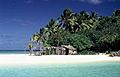
Tonga has 169 islands, but only 36 of them have people living on them. These islands are grouped into three main areas: Vava'u, Ha'apai, and Tongatapu. They stretch out over an 800-kilometer (500-mile) line from north to south. The total land area of Tonga is only 747 square kilometers (288 square miles). However, because the islands are so spread out, Tonga has a very large "Exclusive Economic Zone" of 659,558 square kilometers (254,657 square miles). This is the area of ocean where Tonga has special rights to explore and use marine resources.
The biggest island is Tongatapu, where the capital city, Nukuʻalofa, is located. Tongatapu covers 257 square kilometers (99 square miles). The islands of Tonga are formed in two main ways. Most islands have a base made of limestone, which comes from old coral reefs that were pushed up from the ocean. Other islands are made of limestone on top of a volcanic base.
Contents
Tonga's Tropical Weather
Tonga has a tropical climate, which means it's warm all year round. There's a clear warm season from December to April, when temperatures can go above 32°C (90°F). The cooler season is from May to November, with temperatures usually staying below 27°C (81°F).
As you move from Tongatapu in the south to the northern islands closer to the Equator, the temperature gets a bit warmer, from 23°C to 27°C (73°F to 81°F). The amount of rain also increases, from 1,700 to 2,970 millimeters (67 to 117 inches) per year. March is usually the wettest month, with about 263 millimeters (10.4 inches) of rain. The air is quite humid, with an average daily humidity of 80%. Sometimes, strong storms called cyclones can happen between October and April.
How Tonga's Islands Were Formed
Even though Tonga is divided into three main island groups, its islands are actually part of two different chains formed by geology. These chains run side-by-side.
Volcanic Islands in the West
The islands in the western chain are all volcanic. These include islands like ʻAta, Tofua, Kao, and Late. They are part of what is called the Tongan Volcanic Arc. These volcanoes were created when the Pacific plate (a huge piece of the Earth's crust) slides under the Australia-India plate at the Tonga Trench. When the Pacific plate goes deeper, the rock heats up and rises to the surface, forming volcanoes. There aren't many coral reefs around these volcanic islands, except for Niuatoputapu.
Coral Islands in the East
The eastern islands are not volcanic. They sit on top of the Tonga ridge, which is mostly underwater and runs next to the volcanic chain. Most of these islands are low-lying coral limestone islands, like Tongatapu, Vava'u, and Lifuka. Some are just sand islands, like 'Uoleva and 'Uiha.
These islands are surrounded by many coral reefs. These reefs protect the islands and provide lots of resources. They have been important for human settlements in Tonga since the first people arrived around 900 BCE.
Volcanic Soil and New Islands
The volcanoes in the Tongan Volcanic Arc have been very helpful. They provide a rich soil called "andesite tephra" to the islands on the Tonga ridge. This soil is great for farming and helps grow many crops. The volcanic rock was also used by early settlers for tools, weights, cooking stones, and decorations.
In late 2014 and early 2015, a new volcanic island appeared next to Hunga Ha'apai. This new island is about 1 kilometer (0.6 miles) wide and 2 kilometers (1.2 miles) long. It was formed by a volcanic eruption and is about 100 meters (328 feet) tall, made of ash and large rocks. Tonga has a moderate amount of volcanic activity. Fonualei has been active recently, and Niuafo'ou has caused people to evacuate in the past. Other active volcanoes include Late and Tofua. Tonga can also experience earthquakes and volcanic activity at places like Fonuafo'ou and Late'iki.
Quick Facts About Tonga's Geography

Here are some interesting facts about Tonga's geography:
- Location: Tonga is located at about 20° South latitude and 175° West longitude.
- Area:
* Total land and water: 747 square kilometers (288 square miles) * Land only: 717 square kilometers (277 square miles) * Water only: 30 square kilometers (12 square miles)
- Coastline: Tonga has 419 kilometers (260 miles) of coastline.
- Ocean Rights:
* Continental shelf: Tonga claims rights to the seabed up to 200 meters (656 feet) deep. * Exclusive Economic Zone: This zone extends 659,558 square kilometers (254,657 square miles) and 200 nautical miles from its coast. * Territorial sea: Tonga's territorial waters extend 12 nautical miles from its shores.
- Highest and Lowest Points:
* Lowest point: The Pacific Ocean at 0 meters (0 feet) below sea level. * Highest point: An unnamed spot on Kao island, which is 1,033 meters (3,389 feet) high.
- Land Use:
* About 21.33% of the land is used for growing crops that need to be replanted often. * About 14.67% of the land is used for crops that stay for a long time, like fruit trees. * The remaining 64.00% is used for other purposes (data from 2011).
- Environmental Agreements: Tonga is part of international agreements to protect the environment. These include agreements on Biodiversity, Climate Change (including the Kyoto-Protocol), Desertification, Law of the Sea, Marine Dumping, Marine Life Conservation, Ozone Layer Protection, and Ship Pollution.
Tonga's natural resources include fish and very fertile soil. Some environmental challenges Tonga faces are deforestation (clearing forests) for farming and building. Also, coral reefs are sometimes damaged by starfish and people collecting coral and shells. Overhunting also threatens the native sea turtle populations.
Images for kids
-
Nuku Island Vava'u

See also
 In Spanish: Geografía de Tonga para niños
