Toonerville, Missouri facts for kids
Toonerville is a small place in St. Charles County, in the U.S. state of Missouri. It's not a city with its own government, but rather a community that grew up around a gas station.
History of Toonerville
How Toonerville Got Its Name
Toonerville started as a gas station by the road. The owner put a picture from a popular comic strip on his sign. Because of this, the community was named after the comic strip called Toonerville Folks.
A Key Location During World War II
In the 1930s, the area around Weldon Spring was quite cut off from the bigger St. Louis area. This was mostly because of the Missouri River. Toonerville, along with two other towns, Hamburg and Howell, were important links to the outside world. This was because the Missouri, Kansas, and Texas Railroads had stops in Hamburg.
Southern St. Charles County got a direct connection to St. Louis when the Daniel Boone Bridge was finished in 1937. People living there hoped this bridge would bring more chances for the county. However, it also gave the U.S. Army a quiet, rural spot in Missouri. They wanted to use this land to make weapons for the upcoming WWII.
Building a Weapons Factory
Before the attacks on Pearl Harbor, the U.S. Army needed a secret place. They wanted to develop powerful explosives like TNT. In October 1940, local newspapers announced big news. The U.S. Army was going to buy about 17,000 acres of land. The people living in these areas had three months to move out of their homes.
Houses, churches, and school buildings were quickly taken down. The community of Toonerville, as it was known, disappeared within three months of the order.
The Weldon Spring Ordnance Works, a factory run by Atlas Power Company, started making weapons in 1941. It employed over 5,000 people and had more than 1,000 buildings. The factory stopped making weapons on August 15, 1945, when Japan gave up in the war. By that time, the plant had made over 700 million tons of TNT.
From Weapons to Uranium
After the war, some of the land was sold to conservation groups. But the United States Atomic Energy Commission kept 2,000 acres. In 1955, they built a plant there to process uranium ore. This plant, called the Weldon Spring Uranium Feed Mill Plant, turned raw uranium ore into "yellow cake." This was a concentrated form of uranium that was then sent to other countries. The uranium plant stopped working in 1966.
During the Vietnam War, the Army thought about using the land to make Agent Orange. However, this plan was never carried out. The land then sat empty for twenty years. It had old, dirty equipment and dangerous chemicals left behind.
Cleaning Up the Area
The U.S. Department of Energy took over the site in the 1980s. They began to study how to clean up the dangerous and radioactive waste. This started a long and sometimes difficult project. In 1992, the Department of Energy, along with state and county governments and thousands of local people, worked together. They moved the dirty materials from the Weldon Spring site to a special 45-acre area. This area was designed to safely hold the dangerous waste for over a thousand years. This important cleanup site is officially called the Weldon Spring Site Remedial Action Project (WSSRAP).
Nature and Parks
Protecting the Land
After World War II, the army started selling parts of the land. The Missouri Department of Conservation bought 7,000 acres. This was made possible with a donation from August Busch. The University of Missouri bought another 7,000 acres, which was later sold to the Conservation Department. Today, this land is part of the Busch Memorial Conservation Area and the Weldon Spring Conservation Area. These areas are now used for protecting nature and for people to enjoy.
Fun Things to Do in Toonerville
After all the hard work to clean up the dangerous materials, the land is now a great place for outdoor activities. You can go fishing, hiking, hunting, and bicycling there.
The Weldon Spring Cleanup Site
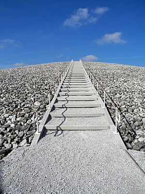
In 2001, a huge structure was finished at the Weldon Spring site. It covers about 45 acres and holds 1.5 million cubic yards of dangerous waste material. Visitors can climb the stairs that lead to the top of this massive structure. From the peak, there's a viewing platform. Plaques there give information about the local area, its history, and how this waste site was built.
Visitors can also see the 9,000-square-foot interpretive center. This building is at the base of the structure. It was once used to check workers for radioactivity. The very top of the Weldon Spring waste cell is the highest point in all of St. Charles County!
Explore the Lewis and Clark Trails
There are two special trails within the Weldon Spring Conservation area. They are south of Route 94 and north of the Missouri River. Both trails meet up at a beautiful spot with a view of the Missouri River.
The Lewis Trail
The Lewis Trail is the longer of the two, at 7.9 miles. It goes from Route 94 down towards the Missouri River. It also loops closer to the Missouri Bluffs Golf Club before heading back north towards Route 94.
The Clark Trail
The Clark Trail is about 5.3 miles long. It starts on the same path as the Lewis Trail for the first two and a half miles. Then, the trails split near the Missouri River.
 | Valerie Thomas |
 | Frederick McKinley Jones |
 | George Edward Alcorn Jr. |
 | Thomas Mensah |


