
Topaz Canyon facts for kids
Quick facts for kids Topaz Canyon |
|
|---|---|

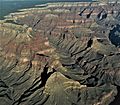
Topaz Canyon-(left), Slate Canyon-(right)
(center)-Diana Temple, with Marsh Butte at its northeast terminus |
|

Topaz_Canyon
Location in Arizona
|
|
| Floor elevation | 2,654 ft (809 m) |
| Length | ~4.0 mi southwest-northeast |
| Geography | |
| Location | (west)-Grand Canyon, (northern)-Arizona, United States |
| Topo map | Grand Canyon, USGS |
| Rivers | Topaz Creek |
Topaz Canyon is a long, narrow valley in the western part of the Grand Canyon, right below the South Rim. It's one of several canyons that stretch northeast towards the Colorado River in the western part of Grand Canyon National Park. It was named Topaz Canyon because of the beautiful, jewel-like rocks found in the area.
Topaz Canyon forms the southeast edge of a large, forested landform called Diana Temple. Another canyon, Slate Canyon, forms Diana Temple's northwest edge.
The northeast end of Topaz Canyon meets up with Boucher Canyon and the Tonto Trail. The Boucher Trail, which starts in Hermit Canyon, also ends where Topaz and Boucher Canyons meet.
The middle and lower parts of Topaz Canyon are made of rocks from the Tonto Group. You can easily see the dull-green slopes of the Bright Angel Shale here. Closer to the Colorado River, there are short, strong cliffs made of Tapeats Sandstone. This sandstone forms the Tonto Platform, which is where the Tonto Trail runs. This platform is also part of the Great Unconformity, a huge gap in time (about 1,000 million years) where a lot of rock layers are missing.
The upper cliffs of Topaz Canyon are made of different rock layers, including Kaibab Limestone, Toroweap Formation, Coconino Sandstone, and Hermit Shale. Below these are the red cliffs of the Supai Group and Redwall Limestone. These same rock layers are also found on Diana Temple to the northwest. Another place called Vesta Temple, located between Topaz Canyon and Boucher Canyon, has most of its upper rock layers worn away. However, Vesta Temple still has a remaining cliff of Kaibab Limestone on a shelf of Toroweap Formation, sitting on top of the strong Coconino Sandstone.
Contents
How Water Flows in Topaz Canyon
Topaz Canyon is part of a "twin-canyon" water system. Vesta Temple sits between Topaz Canyon (to its northwest) and Boucher Canyon (to its southeast).
The water that forms Topaz Canyon starts near Mescalero Point, which is a spot on the South Rim. This is also where Diana Temple begins. The water for Boucher Canyon starts from Mimbreno Point and from the side of Eremita Mesa, which is also part of the South Rim. Topaz Creek flows into Boucher Creek, and then Boucher Creek flows into the Colorado River, creating the Boucher Rapids.
Exploring the Geology of Topaz Canyon
Diana Temple and Mescalero Point
.jpg)
The upper part of Topaz Canyon's water system begins at a curved section of the South Rim. Mescalero Point is at the southwest end, and Mimbreno Point is at the southeast. There's a small dip or "saddle" below Mescalero Point that leads to Diana Temple. This saddle is very short, only about 1/16 of a mile, and it goes down to the strong Coconino Sandstone layer.
Diana Temple is about 1 mile long. Its eroded ridge, made of the Supai Group rocks, extends northeast onto a platform of the strong Manakacha Formation. Below this, the platform of the Redwall Limestone stretches even further. At its end, it's separated from Marsh Butte, which is a leftover piece of eroded Redwall cliff.

Vesta Temple and Mimbreno Point

To the southeast of Upper Topaz Canyon is Mimbreno Point. From here, a saddle (a low area between two higher points) about 1/4 mile long leads to Vesta Temple. This saddle is made of the strong Esplanade Sandstone, which is part of the Supai Group. Vesta Temple also stretches from southwest to northeast.
Vesta Temple is about half the length of Diana Temple. It has the same tall cliffs of Coconino Sandstone, sitting on top of Hermit Formation, Supai Group, and Redwall Limestone below. The highest point of Vesta Temple is just a remaining cliff (shaped like a dome) of Kaibab Limestone on a shelf of Toroweap Formation. Unlike Diana Temple, which is covered in trees and plants, Vesta Temple has very few plants.
Gallery
-
(forested)-Diana Temple (left),
Topaz Canyon (bottom left)
(Slate Canyon at center)
Reflist
