
Marsh Butte facts for kids
Quick facts for kids Marsh Butte |
|
|---|---|

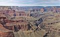
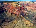
East aspect, from Tonto Trail
|
|
| Highest point | |
| Elevation | 4,721 ft (1,439 m) |
| Prominence | 301 ft (92 m) |
| Isolation | 1.51 mi (2.43 km) |
| Parent peak | Diana Temple (6,683 ft) |
| Naming | |
| Etymology | Othniel Charles Marsh |
| Geography | |

Marsh Butte
Location in Arizona

Marsh Butte
Location in the United States
|
|
| Country | United States |
| State | Arizona |
| County | Coconino |
| Parent range | Coconino Plateau Colorado Plateau |
| Protected area | Grand Canyon National Park |
| Topo map | USGS Grand Canyon |
| Type of rock | limestone, shale, sandstone |
| Climbing | |
| First ascent | 1977 |
| Easiest route | class 4 climbing |
Marsh Butte is a mountain peak in the Grand Canyon, Arizona. It stands about 4,721 feet (1,439 meters) tall. This impressive rock formation is located in Coconino County. It's about eight miles northwest of Grand Canyon Village. Marsh Butte is near another peak called Diana Temple. The Tower of Ra stands directly opposite across the deep Granite Gorge.
The butte rises very high above the Colorado River. It goes up over 2,300 feet (700 meters) in just half a mile. Marsh Butte is made of different types of rock. These include limestone from the Mississippian period. It also has older shale and sandstone from the Cambrian period. At the river level, there are even older granite rocks. The area around Marsh Butte has a cold semi-arid climate. This means it's usually dry and can have cold winters.
History of Marsh Butte

In March 1906, this butte was first named "Endymion Dome." It was named after Endymion, a figure from Greek mythology. This was part of a tradition by Clarence Dutton to name Grand Canyon features after gods and heroes.
However, George Wharton James had a different idea. He suggested naming it after a famous scientist. This scientist was Othniel Charles Marsh (1831–1899). He was a very important paleontologist. Paleontologists study fossils to learn about ancient life. Just two months later, in May 1906, the U.S. Board on Geographic Names officially renamed it Marsh Butte. George Wharton James described it in his 1910 book as "a butte of singularly beautiful structure." This means he thought it was a very beautiful and unique mountain.
The first time anyone successfully climbed to the top of Marsh Butte was on October 29, 1977. Pete Baertlein and Mitch McCombs were the climbers. They reached the summit by climbing the east ridge.
See also
- Geology of the Grand Canyon area
Gallery
-
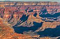
Marsh Butte (centered in bullseye), from Pima Point
-
Marsh Butte centered in bullseye, Geikie Peak behind it
-
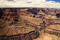
Aerial view with Marsh Butte lower left, Diana Temple upper left, Geikie Peak centered at bullseye.
-
Aerial view of Diana Temple (upper left) and Marsh Butte (lower right)
-
Diana Temple centered at top and Marsh Butte centered at bottom.
Aerial view from ENE. -
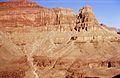
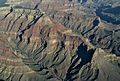
Marsh Butte (end of ridge) formed in Redwall Limestone. Tapeats Sandstone (brown cliff at bottom of photograph), Manakacha Formation (red cliff at top of photograph).


.jpg)


