Toquerville, Utah facts for kids
Quick facts for kids
Toquerville, Utah
|
|
|---|---|

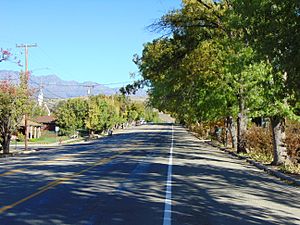
North along Toquerville Boulevard (Utah State Route 17) in Toquerville, October 2016
|
|

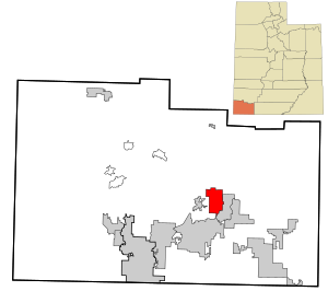
Location within Washington County and Utah
|
|
| Country | United States |
| State | Utah |
| County | Washington |
| Settled | 1858 |
| Named for | Chief Toquer |
| Area | |
| • Total | 22.20 sq mi (57.48 km2) |
| • Land | 22.20 sq mi (57.48 km2) |
| • Water | 0.00 sq mi (0.00 km2) |
| Elevation | 3,383 ft (1,031 m) |
| Population
(2020)
|
|
| • Total | 1,870 |
| • Density | 88.7/sq mi (34.2/km2) |
| Time zone | UTC-7 (Mountain (MST)) |
| • Summer (DST) | UTC-6 (MDT) |
| ZIP code |
84774
|
| Area code(s) | 435 |
| FIPS code | 49-76900 |
| GNIS feature ID | 2413395 |
Toquerville (pronounced TOH-kər-vil) is a city in the state of Utah, United States. It is located in the east-central part of Washington County. In 2020, about 1,870 people lived there.
History of Toquerville
Toquerville got its name from an early Paiute chief. The Paiute are a Native American tribe. The town started with only 19 families in the late 1800s.
For a long time, people in Toquerville mostly worked in farming. But because it is close to Zion National Park, tourism has become very important. Many visitors come to the area. Toquerville was a town until the end of 2000. Then, it officially became a city.
Geography and Location
Toquerville covers an area of about 14.2 square miles (36.8 square kilometers). All of this area is land. There are no large bodies of water within the city limits.
A stream called Ash Creek flows through the community. Utah State Route 17 is a main road that goes through Toquerville. This road connects the city to Interstate 15, which is a major highway. Interstate 15 is about 2.5 miles north of Toquerville.
Population Changes in Toquerville
| Historical population | |||
|---|---|---|---|
| Census | Pop. | %± | |
| 1860 | 79 | — | |
| 1870 | 264 | 234.2% | |
| 1880 | 371 | 40.5% | |
| 1890 | 260 | −29.9% | |
| 1900 | 144 | −44.6% | |
| 1910 | 186 | 29.2% | |
| 1920 | 331 | 78.0% | |
| 1930 | 288 | −13.0% | |
| 1940 | 263 | −8.7% | |
| 1950 | 219 | −16.7% | |
| 1960 | 197 | −10.0% | |
| 1970 | 185 | −6.1% | |
| 1980 | 277 | 49.7% | |
| 1990 | 488 | 76.2% | |
| 2000 | 910 | 86.5% | |
| 2010 | 1,370 | 50.5% | |
| 2020 | 1,870 | 36.5% | |
| 2023 (est.) | 1,970 | 43.8% | |
| U.S. Decennial Census | |||
The population of Toquerville has changed a lot over the years. In 2000, there were 910 people living in the town. The city had about 64 people per square mile.
Most of the people living in Toquerville are White. A small number of people are Native American, Asian, or African American. Some people are from other races or from two or more races. About 2.86% of the people are Hispanic or Latino.
In 2000, there were 282 households in Toquerville. About 37% of these households had children under 18 living there. Most households were married couples living together. The average household had about 3 people.
The population also varied by age. About 33% of the people were under 18 years old. About 14% of the people were 65 years or older. The average age in Toquerville was 34 years old.
See also
 In Spanish: Toquerville para niños
 | Claudette Colvin |
 | Myrlie Evers-Williams |
 | Alberta Odell Jones |


