Toutle River Sediment Retention Structure facts for kids
Quick facts for kids Sediment Retention Structure |
|
|---|---|

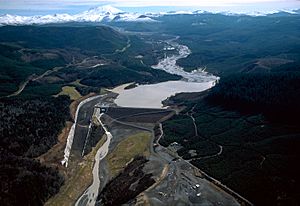
Aerial photograph looking upriver with Mount St. Helens in the background
|
|
| Official name | Sediment Retention Structure |
| Location | Cowlitz County, Washington, United States |
| Coordinates | 46°21′41″N 122°33′06″W / 46.36139°N 122.55167°W |
| Construction began | December 1986 |
| Opening date | December 1989 |
| Construction cost | $65 million |
| Operator(s) | US Army Corps of Engineers |
| Dam and spillways | |
| Impounds | North Fork Toutle River |
| Height | 184 ft (56 m) |
| Length | 1,888 ft (575 m) |
| Reservoir | |
| Total capacity | 160,000 acre⋅ft (200,000,000 m3) (now silted) |
| Surface area | 3,200 acres (13 km2) |
The Sediment Retention Structure is a special kind of dam built from earth. It is located on the North Fork Toutle River in Washington State, USA. This dam is very long, about 1,888 feet (575 m), and stands 184 feet (56 m) tall.
The United States Army Corps of Engineers finished building it in 1989. Its main job is to stop mud and dirt from the 1980 eruption of Mount St. Helens from causing floods. It helps protect towns along the Toutle and Cowlitz rivers.
Why the Dam Was Built
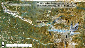
The huge eruption of Mount St. Helens in 1980 sent a lot of ash, rock, and mud into the rivers. This material is called sediment. If too much sediment builds up in a river, it can make the river shallower. This increases the risk of floods, especially during heavy rains.
The Sediment Retention Structure was built to catch this extra sediment. It acts like a giant catcher's mitt for the river. This helps keep the rivers clear and reduces the chance of flooding in nearby communities.
How the Dam Works
When the dam was first built, experts thought the area behind it would fill up slowly. They expected it to be full by the year 2035. However, more mudslides and sediment from storms filled the area much faster than expected.
By 2012, the basin behind the dam was almost completely full. This meant a lot of sediment started flowing over the dam and continued downstream. This was not ideal, as the dam's purpose was to trap the sediment.
Making the Dam Taller
To help the dam work better, its spillway was made taller. The spillway is like a channel that lets water flow over the dam. In 2013, workers raised the spillway by 7 feet (2.1 m).
Making the spillway higher helped the dam trap more sediment. It made the area behind the dam flatter, allowing more mud and debris to pile up. This project helped the dam continue to do its job for several more years.
Location and Importance
The Sediment Retention Structure is located about 13 miles (21 km) upstream from where the North Fork Toutle River joins the main Toutle River. It is also about 30.5 miles (49.1 km) from where the Toutle River flows into the Cowlitz River.
The dam is important for many towns downstream. These include Castle Rock, Kelso, and Longview. By trapping sediment, the dam helps protect these communities from potential floods.
 | Aaron Henry |
 | T. R. M. Howard |
 | Jesse Jackson |


