Trans-Amazonian Highway facts for kids
The Trans-Amazonian Highway, officially known as BR-230, is a very long road in Brazil. It was opened on September 27, 1972. This highway stretches for about 4,000 kilometers (2,500 miles). This makes it the third longest highway in Brazil.
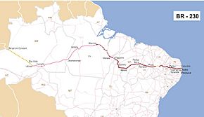
The road goes through the huge Amazon forest. It crosses several Brazilian states. These include Paraíba, Ceará, Piauí, Maranhão, Tocantins, Pará, and Amazonas. It starts near Saboeiro and ends near the town of Lábrea.
Contents
Building the Trans-Amazonian Highway
The idea for this highway started with the Brazilian government in power from 1964 to 1985. They wanted to control remote areas of Brazil. They also aimed to use the natural resources found there. The highway was meant to connect these distant regions with the rest of the country. It was also planned to link up with Colombia, Peru, and Ecuador.
Another big reason for building the road was to help people in the Northeast region. This area often suffered from droughts. The highway would open up new, empty land in the rainforest for people to settle. The original plan was for a fully paved road, 5,200 kilometers (3,200 miles) long. However, these plans changed after the highway was opened.
Challenges in Construction
Building the highway was very difficult. It cost a lot of money. Also, Brazil faced financial problems in the late 1970s. Because of this, only a part of the highway was paved. This paved section went from the start of the road to about 200 kilometers (124 miles) past Marabá.
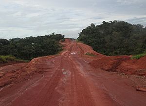
Not having a fully paved road caused many problems. Traveling on the unpaved parts is extremely hard during the rainy season. This season lasts from October to March. In the wet season, cars often get stuck in the muddy road. In the dry season, there are many potholes that can damage vehicles.
Workers building the road were often isolated. They had no way to communicate with the outside world. Visits to nearby cities were their only contact. However, builders used tough methods learned from building the Belém-Brasília Highway.
Modern Updates and Paving
The Brazilian government plans to pave the entire highway with asphalt. As of December 2009, paving was happening between Ruropolis and Itaituba. It was also being paved north to Santarém. This will help connect soy farms to trucking routes in southern Brazil. Some parts of the road west of Itaituba are still untouched. They can be as narrow as 2 meters (6.5 feet) wide.
In 2019, the government announced plans to let private companies manage parts of BR-230. This is to help pave more sections of the road. In September 2022, a 33.3-kilometer (20.7-mile) paved section was finished. This part is in northern Tocantins. Still, many parts of the road in the Amazon remain unpaved.
What is the Trans-Amazonian Highway Like?
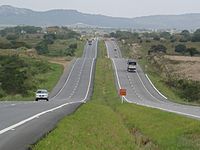
The BR-230, or Transamazônica, is a cross-country highway. It is the third longest in Brazil, measuring 4,260 kilometers (2,647 miles). It connects the port city of Cabedelo in Paraíba to Lábrea in Amazonas. It passes through some of Brazil's main cities.
The highway also links to port areas in Pará, like Port of Santarém, Marabá, Altamira, and Itaituba. It also connects to ports on the Northeast coast, such as Suape Port. In Paraíba, it is key for moving people and goods. It connects cities like João Pessoa, Campina Grande, Patos, and Pombal. These are the biggest economic centers in the state. The highway crosses Paraíba for 521 kilometers (324 miles). Traffic conditions are good up to the border with Ceará.
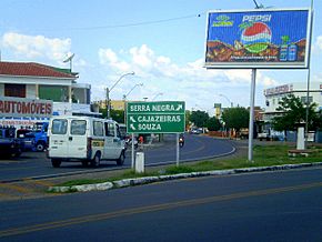
The first 147.6 kilometers (91.7 miles) of the highway, from Cabedelo to Campina Grande, were doubled. This means it has two lanes in each direction. More doubling is planned for the section between Campina Grande and Cajazeiras.
The highway was designed to better connect northern Brazil with the rest of the country. It was opened on August 27, 1972. However, it was not finished, and many sections still need paving. The original plan was for an 8,000-kilometer (5,000-mile) paved highway. It would connect northern and northeastern Brazil with Peru and Ecuador. This plan changed, and construction stopped at Lábrea. The highway now totals 4,260 kilometers (2,647 miles).
How the Highway Helps the Economy
The BR-230 plays an important role in the economy of several Brazilian states. It helps transport goods and people, supporting different industries.
Economic Impact in Paraíba
Paraíba's economy is the 19th richest in Brazil. It is the sixth richest in the Northeast region. The highway helps connect cities like João Pessoa, Campina Grande, and Cabedelo. These cities are major economic hubs.
Historically, Paraíba's economy focused on farming, especially sugar cane. Today, it still produces many crops like pineapple, cassava, and bananas. It also has livestock, including chickens and cattle.
The state's industries include construction, leather, footwear, and food. Most industries are in the João Pessoa area and Campina Grande. The highway helps these industries by making it easier to move products. Paraíba exports sugar, alcohol, footwear, and textiles to other countries.
Economic Impact in Ceará
Ceará's economy has grown a lot since the 1960s. The state offered tax benefits to companies. This helped bring more industries and people to cities. Today, the service sector, including tourism, is very important.
Farming and livestock are still key parts of Ceará's economy. Farmers grow beans, corn, rice, and fruits like melon and pineapple. They also raise cattle, pigs, and goats. The state has mineral resources like iron, clay, and granite. It also has Brazil's largest uranium reserve.
Ceará's industries make clothing, food, and shoes. Most factories are near Fortaleza. The BR-230 helps these industries by providing transport routes for raw materials and finished goods. Trade is also very important, making up over 70% of the state's economy.
See also
 In Spanish: Transamazónica para niños
- Trans-Amazonian Railway
- Madeira-Mamoré Railroad
 | Kyle Baker |
 | Joseph Yoakum |
 | Laura Wheeler Waring |
 | Henry Ossawa Tanner |


