
Transportation in Tulsa, Oklahoma facts for kids


Getting around in Tulsa, Oklahoma is easy thanks to its bus system and a network of major roads and highways. These roads are set up in a grid, making it simple to find your way. Plus, a famous old road called Route 66 runs right through Tulsa. You can still drive on it and see old motels and restaurants that remind people of its past.
The main bus service in Tulsa is called Tulsa Transit. They have 97 buses that travel on 19 different routes. These buses serve Tulsa and nearby towns like Broken Arrow, Sand Springs, and Jenks.
Tulsa Transit has two main stations:
- The Memorial Midtown Station is located at 7952 E. 33rd St.
- The Denver Avenue Station is at 319 S. Denver, near the BOK Center in Downtown.
Most bus routes pass through one or both of these stations. This makes it easier for people to get to work or events in Downtown or Midtown. Buses stop at many important places, including Tulsa Community College, Oklahoma State University-Tulsa, and various shopping areas, hotels, and schools.
Tulsa is also adding a new type of bus service called Bus Rapid Transit (BRT) along Peoria Avenue. These BRT buses will run more often, have better stations, and offer faster travel times. Tulsa is one of the first cities to try this modern bus system.
Contents
How Tulsa's Transportation Started
For a long time, Tulsa's streets were just dirt paths. The city started paving roads in 1906. At first, they used bricks, but it was slow because there weren't enough bricks. Later, they used concrete or asphalt.
Streetcars: Trams of the Past
Imagine electric trains running on tracks right through the city streets! These were called streetcars. The Tulsa Street Railway Company (TSR) started in 1905. By the end of 1906, their electric streetcars were running in Downtown Tulsa.
More streetcar lines were built over the years. By 1923, TSR had 21 miles of track and 52 streetcars. However, as more people bought cars and taxis became popular, fewer people rode the streetcars. The streetcar system eventually stopped running in 1936.
Another company, the Oklahoma Union Traction Company (OUT), also had a streetcar line. It connected Owen Park to an area now called Swan Lake. OUT went out of business in 1935. After that, all public transportation in Tulsa switched to buses.
Tourist Trolley: A Fun Ride
In 2012, Tulsa brought back a special "Tulsa Trolley" system for fun! This trolley ran on Friday and Saturday evenings. It took people for free to popular entertainment areas like the Blue Dome, Brady Arts, and Deco Districts.
Interurban Trains: Connecting Towns
Interurban trains were like bigger streetcars that connected different towns. In 1911, the Sand Springs Railway built an interurban line connecting Tulsa and Sand Springs. Another line, the Tulsa Sapulpa Union Line, connected Tulsa and Sapulpa to oil fields.
These interurban lines are no longer used for passengers. The Sand Springs line stopped running in 1955. The Tulsa Sapulpa line still operates today, but it only carries freight (goods) between Sapulpa and Tulsa.
Railroads: Long-Distance Trains
In the past, Tulsa was a busy hub for long-distance passenger trains. Until the late 1950s, several major railway companies like Frisco, Katy, and Santa Fe had trains leaving from Tulsa's Tulsa Union Depot. These trains traveled to big cities like Chicago, Kansas City, St. Louis, Oklahoma City, Dallas, and Houston.
For a short time recently, a company tried to run a passenger train called the Eastern Flyer between Tulsa and Oklahoma City.
Tulsa's Highway System
Tulsa has a big network of highways that help people travel around the city and beyond.
- Interstate 44 (also called Skelly Drive Bypass) crosses Tulsa from east to west through the middle of the city.
- Interstate 244 and Interstate 444 form a loop around Downtown Tulsa and go through the northern part of the city. They connect back to Interstate 44.
- U.S. Highway 412 runs through Tulsa, often sharing the same path as Interstate 244.
- U.S. Highway 64 becomes the Broken Arrow Expressway to the east and the Sand Springs Expressway to the west.
- U.S. Highway 75 goes north and south through West Tulsa and Downtown.
- U.S. Highway 169, also known as the Mingo Valley Expressway or Pearl Harbor Memorial Expressway, runs north and south through the eastern parts of the city.
- State Highway 11 connects to the Tulsa International Airport from I-244 and Highway 75.
- The Creek Turnpike is a toll road that goes around most of Tulsa and Broken Arrow, connecting back to I-44.
How Tulsa's Streets Are Named
Tulsa has a very organized way of naming and numbering its streets.
- Admiral Place is the main east-west line. Streets north of it are called "streets north," and streets south of it are numbered.
- Main Street is the main north-south line. Avenues west of it are called "west avenues," and avenues east of it are called "east avenues."
Avenues west of Main Street are named after US cities west of the Mississippi River. Avenues east of Main Street are named after US cities east of the Mississippi River. Streets north of Admiral Place are named after important people or events in Tulsa's history. Streets south of Admiral Place are numbered, starting with "1st Street" and going south.
This system means that street names and numbers are the same all over Tulsa, even if a street isn't continuous.
Addresses also follow this system. They tell you how many "hundred blocks" you are from Admiral Place or Main Street. For example, 11th Street, 21st Street, and 31st Street are all major roads that are about a mile apart. This creates a clear grid of main roads across the Tulsa area.
Images for kids
-
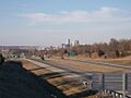
Part of Tulsa's highway network, US-75 connects Downtown's inner-dispersal loop to Interstate 44 and Interstate 244.
-
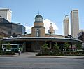
Tulsa Transit's Denver Avenue Station
