
Tripoli, Greece facts for kids
Quick facts for kids
Tripoli
Τρίπολη
|
|
|---|---|
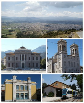 Clockwise from top: Panoramic view of the City of Tripoli, Saint Basil Cathedral in downtown Tripoli, Railway Station of Tripoli, Malliaropoulio Municipal Theater, and the Court House of Tripoli with the Areos Square in front of it.
|
|

Tripoli
Location in Greece
|
|
| Country | Greece |
| Administrative region | Peloponnese |
| Regional unit | Arcadia |
| Area | |
| • Municipality | 1,475.8 km2 (569.8 sq mi) |
| • Municipal unit | 119.3 km2 (46.1 sq mi) |
| Elevation | 655 m (2,149 ft) |
| Population
(2021)
|
|
| • Municipality | 44,165 |
| • Municipality density | 29.9261/km2 (77.508/sq mi) |
| • Municipal unit | 33,026 |
| • Municipal unit density | 276.83/km2 (716.99/sq mi) |
| Community | |
| • Population | 30,448 (2021) |
| Time zone | UTC+2 (EET) |
| • Summer (DST) | UTC+3 (EEST) |
| Postal code |
221 00
|
| Area code(s) | 2710 |
| Website | www.tripolis.gr |
Tripoli (Greek: Τρίπολη, Trípoli) is a city in the central part of Greece. It is the capital of the Peloponnese region. It is also the capital of the Arcadia area. In 2021, the city and its surrounding area had about 44,165 people living there.
Contents
What's in a Name?
In the Middle Ages, this area was called Drobolitsa. This name might have come from the Greek words for 'Water City'. Another idea is that it came from a South Slavic language, meaning 'Plain of Oaks'.
Some people in the 1700s and 1800s thought the name meant "three cities." They believed it referred to three ancient cities nearby. However, experts now think these ideas are not correct. Later, the Ottoman Turks called the town Tripoliça.
A Look Back in Time

Not much is known about Drobolitza from long ago. In 1467, it was listed as an abandoned Byzantine site. After the Ottomans took over the area, the main center moved to Drobolitza. This happened sometime after 1467.
Later, around 1540, the focus shifted to a settlement below the fortress called Tarabluca. This became the new important center. In 1829, a French archaeologist visited and still saw the old ruins of Drobolitza.
In 1770, during a Greek uprising, the revolutionary armies were stopped outside Tripolitsa. Sadly, many Greek people were harmed when Ottoman forces entered the city.
Before the Greek War of Independence, Tripolitsa was an important Ottoman center in the Peloponnese. It had many Muslim and Jewish residents. During the Greek War of Independence, Greek fighters took the city on October 17, 1821. Many people from the Muslim and Jewish communities were harmed during this event.
Ibrahim Pasha took the city back in June 1825. Before he left the Peloponnese in 1828, he destroyed the city and its walls.
After Greece became an independent country in 1830, the old Ottoman buildings in Tripolizza were completely taken down. Tripoli was rebuilt and became an important city in the new Kingdom of Greece. It served as the capital of the Arcadia area. In the 1800s and 1900s, Tripoli grew into a major center for government, business, and travel in central and southern Peloponnese.
Geography and Weather
Tripoli has a hot-summer Mediterranean climate. This means it has hot, dry summers and mild, wet winters. The city is in the middle of the Peloponnese. It sits in a large flat area, like a big bowl, about 650 meters (2,130 feet) high.
To the west of the city is the thick forest of the Mainalo mountains. The flat area around Tripoli has been changed over time to become farmland. Sometimes, after very rainy winters, a temporary lake called Lake Taka forms in the southwest. This lake is now controlled to store water for farming.
Because Tripoli is inland and high up, its climate can feel a bit like a continental one. Winters can have very cold temperatures. In summer, temperatures can go above 38°C (100°F). In winter, temperatures below -10°C (14°F) have been seen. Snow can fall several times between November and early April.
The city's main squares are along its main street. This street also connects to a highway going to Pyrgos and Patras. One square is named Kennedy, and another is named Georgiou B'. The southern part of the city has a main street named Washington. The main part of the city is built around the old castle walls. These walls were put up when the Ottomans ruled Greece. There is also an industrial area in the southwest.
| Climate data for Tripolis (1957–2010) | |||||||||||||
|---|---|---|---|---|---|---|---|---|---|---|---|---|---|
| Month | Jan | Feb | Mar | Apr | May | Jun | Jul | Aug | Sep | Oct | Nov | Dec | Year |
| Record high °C (°F) | 20.4 (68.7) |
24.2 (75.6) |
25.4 (77.7) |
29.8 (85.6) |
36.6 (97.9) |
39.8 (103.6) |
42.2 (108.0) |
39.8 (103.6) |
35.4 (95.7) |
33.8 (92.8) |
26.8 (80.2) |
22.6 (72.7) |
42.2 (108.0) |
| Mean daily maximum °C (°F) | 9.6 (49.3) |
10.5 (50.9) |
13.3 (55.9) |
17.4 (63.3) |
23.0 (73.4) |
28.0 (82.4) |
30.4 (86.7) |
30.5 (86.9) |
26.2 (79.2) |
20.7 (69.3) |
15.5 (59.9) |
10.9 (51.6) |
19.7 (67.4) |
| Daily mean °C (°F) | 5.1 (41.2) |
5.7 (42.3) |
8.0 (46.4) |
11.9 (53.4) |
17.0 (62.6) |
21.9 (71.4) |
24.5 (76.1) |
23.9 (75.0) |
20.1 (68.2) |
14.4 (57.9) |
10.0 (50.0) |
6.7 (44.1) |
14.1 (57.4) |
| Mean daily minimum °C (°F) | 0.7 (33.3) |
1.0 (33.8) |
2.4 (36.3) |
4.9 (40.8) |
8.3 (46.9) |
12.0 (53.6) |
14.4 (57.9) |
14.6 (58.3) |
11.4 (52.5) |
8.1 (46.6) |
4.7 (40.5) |
2.4 (36.3) |
7.1 (44.7) |
| Record low °C (°F) | −17.0 (1.4) |
−15.8 (3.6) |
−16.0 (3.2) |
−4.0 (24.8) |
−0.2 (31.6) |
4.0 (39.2) |
7.6 (45.7) |
7.8 (46.0) |
0.4 (32.7) |
−2.6 (27.3) |
−5.8 (21.6) |
−11.0 (12.2) |
−17.0 (1.4) |
| Average precipitation mm (inches) | 103.6 (4.08) |
89 (3.5) |
74.8 (2.94) |
53.9 (2.12) |
37.6 (1.48) |
23.3 (0.92) |
19.4 (0.76) |
19.3 (0.76) |
29.2 (1.15) |
66.1 (2.60) |
108.8 (4.28) |
125.8 (4.95) |
750.8 (29.54) |
| Average precipitation days | 13.7 | 12.8 | 12.5 | 11.5 | 9.2 | 6.1 | 4.0 | 3.3 | 4.8 | 9.8 | 11.9 | 15.6 | 115.2 |
| Average relative humidity (%) | 76.1 | 74.4 | 69.3 | 62.5 | 57.0 | 47.4 | 44.1 | 45.9 | 54.5 | 75.4 | 77.4 | 77.5 | 63.5 |
| Source: Hellenic National Meteorological Service | |||||||||||||
Surrounding Area and Geology


The area around Tripoli has a special landscape. It has many flat plains and "closed basins." These are like big dips in the ground. Besides the Tripoli Basin, there are other basins nearby, such as the "Argon Pedion" and the basins of Levidi and Vlacherna Arcadia.
What makes these plains special is how water drains. Instead of rivers flowing on the surface, water sinks into the ground. It goes through natural holes called ponors (in Greek: καταβόθρες) and then flows underground. There are 45 such holes in these basins. Around Lake Taka, there are 7 ponors. When there's a lot of rain in winter, the ground can flood. Temporary lakes can form because the water drains slowly through these holes. This can sometimes delay farming.
Local Government


The municipality of Tripoli was created in 2011. It joined together 8 smaller areas that used to be separate municipalities. These areas are now called municipal units.
The municipality covers an area of about 1,475 square kilometers (570 square miles). The central municipal unit of Tripoli covers about 119 square kilometers (46 square miles).
Parts of Tripoli
The municipal unit of Tripoli is divided into these smaller communities:
- Agios Vasileios
- Agios Konstantinos
- Evandro
- Makri
- Merkovouni
- Pallantio
- Pelagos
- Perthori
- Skopi
- Thanas
- Tripoli
Learning in Tripoli
Tripoli is home to the main campus of the University of the Peloponnese. This university was started in 2000.
At the Tripoli campus, you can find the School of Economy, Management, and Informatics. This school has departments for Economics and for Informatics and Telecommunications.
Getting Around

Tripoli is a major travel center because it's in the middle of the Peloponnese. It's about 75 kilometers (47 miles) northeast of Corinth. Pyrgos is 145 kilometers (90 miles) to the east, and Patras is 144 kilometers (89 miles) northwest. Kalamata is 65 kilometers (40 miles) southwest, and Sparti is 60 kilometers (37 miles) south.
You can mainly reach Tripoli from Athens and other parts of Greece using the A7 toll motorway. This highway goes north towards Corinth and south to Kalamata. There's also an older road, the GR-7, which doesn't have tolls.
Tripoli also has a railway line. It used to have passenger trains to Árgos and Corinth. However, these services stopped in 2010.
Military Presence
Tripoli has two of the largest training camps for the Greek Armed Forces. One is for the Hellenic Army, and the other is for the Hellenic Air Force. These are the 251st Army Training Battalion and the 124th Basic Training Wing.
Sports Teams
Tripoli has several sports clubs that play in Greece's higher national leagues for football and basketball.
| Club | Founded | Sports | Achievements |
|---|---|---|---|
| Panarkadikos F.C. | 1927 | Football | Played in Beta Ethniki (a higher league) |
| Asteras Tripolis | 1931 | Football | Plays in Super League Greece (the top league) |
| Arkadikos B.C. | 1976 | Basketball | Plays in A2 Ethniki (a higher league) |
Historical Population
Here's how the population of Tripoli has changed over the years:
| Year | Community | Municipal unit | Municipality |
|---|---|---|---|
| 1981 | 21,337 | – | – |
| 1991 | 22,429 | 26,432 | – |
| 2001 | 25,520 | 28,976 | – |
| 2011 | 30,912 | 33,785 | 47,254 |
| 2021 | 30,448 | 33,026 | 44,165 |
Famous People from Tripoli


Many notable people have come from Tripoli, including:
- Theodoros Kolokotronis (1770–1843), a famous general and leader in the Greek War of Independence.
- Epameinontas Deligeorgis (1829–1879), who served as Prime Minister of Greece.
- Konstantinos Georgakopoulos (1890–1978), a lawyer and politician who was also a Prime Minister of Greece.
- Kostas Karyotakis (1896–1928), a well-known poet.
- Yiannis Kouros (born 1956), an amazing ultramarathon runner.
- Alexandros Papanastasiou (1876–1936), a politician and sociologist who was a Prime Minister of Greece.
- Semni Karouzou (1897–1994), a respected archaeologist and museum curator.
Sister Cities
Tripoli has special connections with other cities around the world. These are called "twin towns" or "sister cities."
 Peine, Germany
 Arcadia, California, United States
Images for kids
-
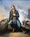
"Death of a Greek soldier during the siege of Tripolizza" by Henri Serrur
-
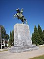
A statue of Theodoros Kolokotronis
-
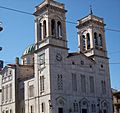
Agios Vasilios (St Basil), Tripoli's cathedral. Facade built with Doliana marble
-
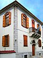
House of Kostas Karyotakis
-
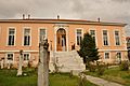
The archaeological museum
-
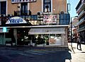
A street in Tripoli
-
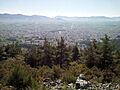
Panoramic view of Tripoli


See also
 In Spanish: Trípoli (Grecia) para niños
