
Tumby Bay, South Australia facts for kids
Quick facts for kids Tumby BaySouth Australia |
|||||||||||||||
|---|---|---|---|---|---|---|---|---|---|---|---|---|---|---|---|

View of the Tumby Bay jetty
|
|||||||||||||||

Tumby Bay
Location in South Australia
|
|||||||||||||||
| Established | 1900 | ||||||||||||||
| Postcode(s) | 5605 | ||||||||||||||
| Elevation | 0 m (0 ft) | ||||||||||||||
| Location | 45 km (28 mi) North of Port Lincoln | ||||||||||||||
| LGA(s) | District Council of Tumby Bay | ||||||||||||||
| State electorate(s) | Flinders | ||||||||||||||
| Federal Division(s) | Grey | ||||||||||||||
|
|||||||||||||||
|
|||||||||||||||
| Footnotes | Adjoining localities | ||||||||||||||
Tumby Bay is a town on the coast of South Australia. It sits on the Spencer Gulf, which is on the eastern side of the Eyre Peninsula. Tumby Bay is about 45 kilometers (28 miles) north of Port Lincoln. It is the main town in the District Council of Tumby Bay area. This town is known for its farms, especially for growing cereal crops and raising sheep. It also has busy fishing and tourism industries.
Contents
History of Tumby Bay
The Barngarla and Nauo nations are the traditional owners of this land. They have a long and special connection to the area.
The bay was first explored by Matthew Flinders in 1802. He named it Tumby Bay after a place in England. Later, in 1840, Governor Gawler changed the name to Harvey's Bay. But on November 15, 1900, the town was officially named Tumby by Governor Tennyson. The bay itself went back to being called Tumby Bay. Finally, on June 14, 1984, the town officially became Tumby Bay.
The first settlers arrived in the 1840s. They mostly farmed wheat and sheep. Tumby Bay quickly became an important place to store and load grain. A jetty was built in 1874. This was only the second jetty on the Eyre Peninsula. It helped to ship copper ore from the Burrowing Mine. The first jetty was removed in 1999 because it was unsafe. But a newer jetty is still used today.
The town's first school opened in 1881. It was called 'Tumby'. The area's first hospital opened in 1913.
Tumby Bay hosted a big music event called Triple J's One Night Stand on April 2, 2011. Bands like Birds of Tokyo and Art vs. Science played there. The town's population grew from 1,000 to over 12,000 people for the event!
Historic Places to See
Tumby Bay has several places listed on the South Australian Heritage Register. These are important places from the past:
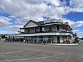
- The historic Tumby Bay Hotel on North Terrace
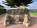
- The Bratten Plough Memorial on the foreshore
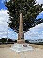
- The War Memorial on the foreshore
- Excell Blacksmith and Engineering Workshop Museum on Barraud Street
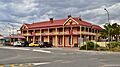
- The Seabreeze Hotel on Mortlock Street
-
Heritage listed Seabreeze Hotel, Tumby Bay 2024
-
Heritage listed Bratten Plough, Tumby Bay 2024
-
Heritage listed Tumby Bay Hotel 2017
-
Heritage listed Soldiers Memorial on the foreshore in Tumby Bay


.jpg)

Geography of Tumby Bay

Tumby Bay is located on a large, calm bay on the western side of Spencer Gulf. Most of the land around Tumby Bay is used for farming. The coast has many white, sandy beaches. The town itself is built on these beaches. To the south, there are tall cliffs.
Inside the bay, Tumby Island is the only island. Further out to sea are the Sir Joseph Banks Group. This is a small group of islands that you can easily reach by boat from Tumby Bay.
Tumby Bay has a Mediterranean climate. This means it has warm to hot summers and wet winters.
Economy and Tourism
Since it was first settled, Tumby Bay has been a farming town. People grow cereal crops and raise sheep and cattle. Like many towns on the Eyre Peninsula, Tumby Bay also has a strong professional fishing industry.

Tourism in Tumby Bay
Tumby Bay is a popular place for holidays, especially in summer. One of the biggest reasons people visit is for fishing. You can catch many types of fish, like King George Whiting and Snapper. Until late 2022, you could fish from the town jetty. But the jetty is now closed for repairs. You can still fish from the beaches, rocks, or from a boat. Boats can also take you to the Sir Joseph Banks Group of islands. In 2001, a marina was built. This makes it easy to launch boats of all sizes in any weather. It also created new places to live.
The bay's calm waters and white sand are great for watersports. You can go swimming, snorkeling, scuba diving, and water skiing. The town has a caravan park, hotels, and apartments for visitors. There are also many shops and facilities in the town.
Scuba Diving Fun
The area around the Tumby Bay jetty is great for scuba diving. You can see amazing sea life on and around the jetty's supports. Divers need to bring their own gear. There isn't a dive shop in Tumby Bay. You can rent equipment from dive shops in Port Lincoln (45 km south-west) or Whyalla (221 km north-east).
Community Life

Tumby Bay has several churches, including Anglican, Uniting, Church of Christ, and Lutheran Churches.
There are also many sports groups in town. These include football, cricket, netball, basketball, tennis, bowls, and golf clubs. Most of these clubs play in local leagues.
The Tumby Bay Area School teaches students from their first year (Reception) up to Year 12. There is also a public library on the school grounds. A hospital helps with the town's health needs.
The town's history is shown at a National Trust Museum. Volunteers help run this museum.
A local historian named Eric Kotz has written two books about life in the area.
A community worker named Janette Octoman lived here. She worked hard for her community. She even tried to be elected to a position that was usually held by men. She also led the state's Country Women's Association. The local council planted trees in her honor.
Transport Around Tumby Bay
You can usually get to Tumby Bay by car. The Lincoln Highway runs along the east coast of the Eyre Peninsula. Tumby Bay has a small airport with a paved runway. It is mostly used by the Royal Flying Doctor Service and planes that spray crops.
As of April 2023, a coach (bus) service runs three times a week. It connects Tumby Bay to Port Lincoln and Adelaide.
Future Port Plans
Land has been bought about 20 kilometers (12 miles) north-east of Tumby Bay. The plan is to build a large port there. This port, called Port Spencer, would export bulk goods. It is located just north of Lipson Cove. If approved, the port could load very large ships. These ships would carry iron ore and possibly grain. This port is expected to be finished by 2023.
There were ideas for a rail line to connect to the Eyre Peninsula Railway at Ungarra. But instead, they plan to use a special pipeline to move iron ore.
