
Turtle Creek (West Branch Susquehanna River tributary) facts for kids
Quick facts for kids Turtle Creek |
|
|---|---|

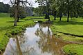
Turtle Creek looking downstream
|
|
| Physical characteristics | |
| Main source | shallow valley in Limestone Township, Union County, Pennsylvania between 620 and 640 feet (190 and 200 m) |
| River mouth | West Branch Susquehanna River in East Buffalo Township, Union County, Pennsylvania 430 ft (130 m) 40°55′34″N 76°51′38″W / 40.9261°N 76.8605°W |
| Length | 8.4 mi (13.5 km) |
| Basin features | |
| Progression | West Branch Susquehanna River → Susquehanna River → Chesapeake Bay |
| Basin size | 12.7 sq mi (33 km2) |
| Tributaries |
|
Turtle Creek is a small river, also called a tributary, in Union County, Pennsylvania. It flows into the West Branch Susquehanna River. The creek is about 8.4 miles (13.5 km) long. It travels through three townships: Limestone, Buffalo, and East Buffalo.
The area of land that drains into Turtle Creek, called its watershed, is 12.7 square miles (33 km2). Most of this land is covered by forests or farms. People have lived near Turtle Creek since the late 1760s. Many mills were built along its banks a long time ago.
Contents
Where Turtle Creek Flows

Turtle Creek starts in a shallow valley in Limestone Township. It flows east and quickly enters Buffalo Township. Then, it turns north for a short distance. Here, it enters a wider valley and gets water from a small stream on its left side.
The creek then turns east-northeast for several miles. It enters East Buffalo Township and receives water from three more small streams on its right. Next, the creek turns east-southeast, and its valley becomes narrower. It gets water from one stream on its left and three more on its right. Finally, it crosses US Route 15 and turns northeast. A short distance later, it joins the West Branch Susquehanna River.
Water Quality and Environment
Some parts of Turtle Creek are considered "impaired," meaning the water quality isn't as good as it should be. The main problem is siltation, which means too much mud and dirt are in the water. This often comes from farming activities nearby. About 8.8 miles (14.2 km) of streams in the watershed are affected.
Every day, about 6,372 pounds (2,890 kg) of dirt and mud, called sediment, flows into Turtle Creek. This adds up to a lot of sediment each year. To make the creek healthier, the amount of sediment needs to be reduced. A lot of this sediment comes from farm fields and the creek's banks.
The land around Turtle Creek is mostly shale, carbonate, and sandstone. These are types of rocks found in the area. The soil in the watershed can also erode, meaning it can be washed away by water.
Life Around Turtle Creek

Turtle Creek is a good place for fish. It's known as a Warmwater Fishery and a Migratory Fishery. This means it supports fish that like warmer water and fish that travel through the creek. In the 1930s, people enjoyed fishing for suckers in the creek.
The areas along the creek's banks, called riparian buffers, are important. They help protect the water quality. However, in some farming areas, these natural buffers are missing or very small. Sometimes, cattle can also get into the creek, which can affect the water.
There's a place called Turtle Creek Park near the creek. It's a popular spot for people to walk and enjoy nature. The park has different types of natural areas, including places where new plants are growing.
History of Turtle Creek
Turtle Creek was officially named before 1769. It was added to a national geographic information system in 1979. Early settlers arrived near the creek in the late 1760s.
In 1770, William Speddy settled about 1 mile (1.6 km) from the creek's mouth. By 1771, a mill was operating on the creek. In 1772, John Aurand built a gristmill (for grinding grain) and a sawmill (for cutting wood) at the mouth of the creek. This mill later became known as Jenkins Mill.
Another mill, a fulling mill (for making cloth), was built in 1792. In 1795, money was left in a will to build a school for poor children near the creek's mouth. In 1842, iron ore was found downstream of the creek's mouth. Later, in 1853, people bought land near the creek to set up a furnace for iron.
Many bridges have been built over Turtle Creek over the years. Some of the older bridges were built in the 1930s and 1960s. Newer bridges have also been added to help people cross the creek safely.
In 1973, Turtle Creek was called a "stream of major concern" in a local plan. Later, in the late 1900s, it was suggested that a greenway (a natural path or corridor) should be created along the creek's floodplain. This would help protect the area and provide a place for people to enjoy.
Images for kids
-
Turtle Creek looking downstream
