Tuusula facts for kids
Quick facts for kids
Tuusula
Tusby
|
||
|---|---|---|
|
Municipality
|
||
| Tuusulan kunta Tusby kommun |
||

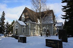
The wooden church of Tuusula
|
||
|
||

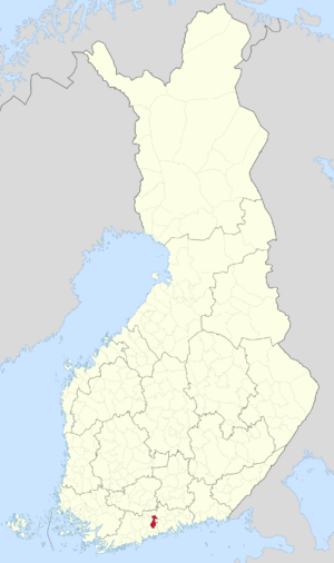
Location of Tuusula in Finland
|
||
| Country | ||
| Region | Uusimaa | |
| Sub-region | Helsinki sub-region | |
| Metropolitan area | Helsinki metropolitan area | |
| Founded | 2009 | |
| Seat | Hyrylä | |
| Villages | Jokela, Kellokoski | |
| Area
(2018-01-01)
|
||
| • Total | 225.45 km2 (87.05 sq mi) | |
| • Land | 219.53 km2 (84.76 sq mi) | |
| • Water | 5.95 km2 (2.30 sq mi) | |
| Area rank | 254th largest in Finland | |
| Elevation | 63 m (207 ft) | |
| Population
(2023-12-31)
|
||
| • Total | 41,338 | |
| • Rank | 27th largest in Finland | |
| • Density | 188.3/km2 (488/sq mi) | |
| Population by native language | ||
| • Finnish | 90.4% (official) | |
| • Swedish | 1.4% | |
| • Others | 8.2% | |
| Population by age | ||
| • 0 to 14 | 18.1% | |
| • 15 to 64 | 63.3% | |
| • 65 or older | 18.6% | |
| Time zone | UTC+02:00 (EET) | |
| • Summer (DST) | UTC+03:00 (EEST) | |
| Postal code |
04301
|
|
| Climate | Dfb | |
Tuusula is a municipality in Finland. It is located in the southern part of the country. Tuusula is in the middle of the Uusimaa region. About 41,000 people live there. This makes it one of the most populated municipalities in Finland. It is also the second largest municipality without official city status. Tuusula is part of the Helsinki metropolitan area. This larger area has about Expression error: Missing operand for +. million people.
The coat of arms of Tuusula has a laurel branch. This represents the many artists who have lived in the area. It also has a wheellock, which is a part of an old gun. This was taken from the coat of arms of the Stålhane noble family, who were important in Tuusula for a long time. Olof Eriksson designed the coat of arms in 1953.
Contents
Where is Tuusula Located?
Tuusula is on the shores of Tuusulanjärvi lake. It is in the Southern Finland province. It is also part of the Uusimaa region.
The total area of Tuusula is 225.45 square kilometres (87.05 sq mi). A small part of this, 5.95 km2 (2.30 sq mi), is water. The population density is 188.3 inhabitants per square kilometre (488/sq mi). This means how many people live in each square kilometer.
Main Population Centers
Tuusula has three main areas where most people live:
- Hyrylä is the main administrative center. About 19,500 people live here.
- Jokela has about 5,300 residents.
- Kellokoski has about 4,300 residents.
The other 4,400 people live in the countryside outside these centers. The main road connecting Hyrylä to Helsinki is the Tuusulanväylä motorway.
Neighboring Areas
Tuusula is surrounded by several other municipalities:
- To the south is Vantaa.
- To the west is Nurmijärvi.
- To the north is Hyvinkää.
- To the northeast are Mäntsälä and Järvenpää.
- To the east are Sipoo and Kerava.
Villages in Tuusula
Tuusula is made up of several villages. These include:
- Huikko
- Hyrylä
- Jokela
- Jäniksenlinna
- Kellokoski
- Lahela
- Myllykylä
- Nahkela
- Paijala
- Riihikallio
- Ruotsinkylä
- Ruskela
- Rusutjärvi
- Savikulma
- Siippoo
- Vanhakylä
A Look at Tuusula's History
The area that is now Tuusula was once part of a larger municipality called Sipoo. In 1643, it became its own church parish. Then, in 1653, it became a separate municipality.
Tuusula's borders have changed over time:
- In 1924, the municipality of Kerava became separate.
- In 1950, the area of Korso was divided between Tuusula, Kerava, and Sipoo.
- In 1951, Järvenpää also became its own municipality.
During the Crimean War (1853–1856), Russian soldiers were stationed in what is now Hyrylä. The modern church area grew around this military camp.
The land in Tuusula has always been good for farming. Other industries started in 1795 when an ironworks was built in Kellokoski. This factory operated until the 1980s. The arrival of a railway in Jokela also helped the area grow.
Artists and Lake Tuusulanjärvi
Later, the beautiful Tuusulanjärvi lake attracted many artists. They came to paint the lovely scenery. Famous Finnish artists and writers made their homes here. These included Jean Sibelius, Juhani Aho, and Pekka Halonen. They followed in the footsteps of Aleksis Kivi, Finland's national poet. He spent his last years in a small hut by the lake.
Today, these artists' homes are popular tourist spots. Sibelius's house, Ainola, is one example. The Tuusula Lake Road, on the eastern side of the lake, is like an outdoor museum.
Important Events
Tuusula has also been the site of some notable events:
- The Jokela rail crash happened here on April 21, 1996. It was a train accident.
- Jokela High School was the location of a tragic school shooting on November 7, 2007.
People from Tuusula
Many interesting people have come from Tuusula:
- Ilmari Juutilainen was a top flying ace in the Finnish Air Force.
- Eino Leino was a famous poet.
- Teemu Suninen is a rally car driver.
Population and Languages
Tuusula is close to Helsinki, so its population has grown a lot. It has more than doubled since 1970.
The official language of Tuusula is Finnish. Until 1943, Swedish was also an official language. Today, only about 2% of the people speak Swedish.
Economy and Transportation
Economy
Because Tuusula is near Helsinki, many people who live there travel to Helsinki for work. Tuusula itself has about 10,000 jobs. Most of these jobs (66%) are in the service industry. About 31% are in other types of work, and 1.5% are in farming. The unemployment rate in 2007 was 3%, which was very low compared to the rest of Finland.
Transportation
From Hyrylä, the center of Tuusula, there are good bus connections to Helsinki. These buses use the Tuusula motorway. Tuusula also has two train stations on Finland's main railway line: Jokela and Nuppulinna. However, the Nuppulinna station closed in 2016.
Schools in Tuusula
Tuusula has a good network of schools for children and young people:
- 18 primary schools
- 4 secondary schools
- 3 high schools
- 1 hospital school
See also
 In Spanish: Tuusula para niños
 | Selma Burke |
 | Pauline Powell Burns |
 | Frederick J. Brown |
 | Robert Blackburn |


