Two Island River facts for kids
Quick facts for kids Two Island River |
|
|---|---|
|
Mouth of the Two Island River
|
|
| Country | United States |
| State | Minnesota |
| County | Cook County, Lake County |
| Physical characteristics | |
| Main source | Cramer, Minnesota 47°36′27″N 91°02′52″W / 47.6074027°N 91.0476481°W |
| River mouth | Schroeder, Minnesota, Lake Superior 47°31′26″N 90°55′19″W / 47.52389°N 90.92194°W |
| Length | 15.0-mile-long (24.1 km) |
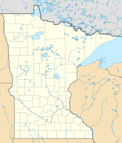
The Two Island River is a river located in the northeastern part of Minnesota, a state in the United States. This river is about 15 miles (24 kilometers) long. It's a relatively short but important waterway in its region.
The river begins near a small place called Cramer, Minnesota. From there, it flows generally southeast. It eventually empties its waters into Lake Superior. Lake Superior is one of the Great Lakes and the largest freshwater lake by surface area in the world. The Two Island River joins Lake Superior at a spot known as Taconite Harbor.
About the Two Island River
The Two Island River is a natural stream of water. It flows across the land, carrying water from higher elevations to lower ones. Rivers like this are important parts of the natural environment. They help shape the landscape and provide homes for many plants and animals.
This river is located in a beautiful part of Minnesota. The area is known for its forests and many lakes. The river's journey takes it through two different counties in Minnesota. These are Cook County and Lake County.
How Did It Get Its Name?
The name "Two Island River" is quite interesting. It comes from a simple observation. Near where the river meets Lake Superior, there are two small lake islands. These islands are located close to the river's mouth.
So, people named the river after these two nearby islands. This is a common way that natural features get their names. They are often named after something unique or noticeable in their surroundings.
Where Does the River Flow?
The Two Island River starts its journey in the northern part of Minnesota. Its source is near Cramer, a small community. From its source, the river travels through a forested and scenic area.
It flows through parts of both Cook County and Lake County. These counties are known for their natural beauty. Finally, the river reaches its end point, which is Lake Superior. This happens near the community of Schroeder, Minnesota. The river's water becomes part of the vast waters of Lake Superior.
 | Toni Morrison |
 | Barack Obama |
 | Martin Luther King Jr. |
 | Ralph Bunche |


