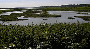
Two Tree Island facts for kids
Two Tree Island is a small island located in Essex, England. It lies northeast of Canvey Island and southwest of Leigh-on-Sea. The island is about 257 hectares (630 acres) in size. A single bridge connects it to the mainland at Leigh.
Contents
Island History
Two Tree Island was created from the Thames Estuary in the 1700s. For a long time, it was used as pasture land for animals. In 1910, a sewage plant was built there. Later, starting in 1936, the whole island became a landfill site for trash. By 1974, only a small part of the island was still used for landfill.
A Home for Wildlife
Today, Two Tree Island is a wonderful nature reserve. The Essex Wildlife Trust looks after it. The eastern part of the island is even a special area called the Leigh National Nature Reserve.
Birdwatching Spots
The island is a great place to see birds. There used to be two bird hides (small shelters for watching birds) on the western side. These hides overlooked a special lagoon, or "scrape," where wading birds like to feed. They also looked out over Benfleet Creek. Sadly, these hides were damaged in 2019. But you can still watch birds from where the hides once stood.
There are two more bird hides on the eastern side of the island. One looks over another scrape, and the other watches over an old landfill reservoir.
Amazing Birds
Many birds come to Two Tree Island. During the breeding season, you can see wader birds and gulls nesting here. One special bird that nests here is the Avocet. These birds are known for their unique upturned beaks.
Island Activities
Besides being a nature reserve, Two Tree Island is also used by the local community.
Boating and Scouts
At the end of the island road, on the south side, there is a concrete jetty. This is managed by the Port of London Authority. There is also an area for storing boats and two car parks. The 6th Westcliff and 2nd Chalkwell Bay Scout groups have their water activity center here.
Model Airplanes
In the center of the west side of the island, there is a small airfield. This is home to the Southend Radio Flying Club and the South Essex Model Aircraft Society. They often have airshows here. You can also see people practicing and training with model airplanes regularly.
Wartime History
Two Tree Island has a connection to war history. At the eastern end of the island, you can find two old military structures called pillboxes. One is on the island itself, and the other is on Leigh Marshes.
Pillbox Structures
These pillboxes were part of a communication and signal system. They were used during World War I. At low tide, you can see the one on the marsh by walking along a path. The pillbox on the island is easy to see, but you cannot go inside because plants are growing there, and it is old and broken. You can reach these pillboxes with a short walk from either the north or south car park.
 | Janet Taylor Pickett |
 | Synthia Saint James |
 | Howardena Pindell |
 | Faith Ringgold |


