
U.S. Route 4 facts for kids
Quick facts for kids
|
|
|---|---|
| Lua error in Module:Infobox_road/map at line 15: attempt to index field 'wikibase' (a nil value). | |
| Route information | |
| Length | 249.84 mi (402.08 km) |
| Existed | 1926–present |
| Major junctions | |
| West end | |
| East end | |
| Highway system | |
| United States Numbered Highways List • Bannered • Divided • Replaced |
|

U.S. Route 4 is an important highway in the United States. It stretches for about 250 miles (400 kilometers). This route connects East Greenbush, New York, which is close to Albany, all the way to Portsmouth, New Hampshire. Along its journey, it also passes through the state of Vermont.
Exploring U.S. Route 4
U.S. Route 4 is a major road that helps people travel across different states. It's like a long, paved path connecting towns and cities. This highway is part of a bigger network of roads called the United States Numbered Highway System. These roads help people drive easily across the country.
Where Does U.S. Route 4 Go?
U.S. Route 4 starts in New York. Its western end is near Albany, a big city in New York. From there, it heads east.
The highway then crosses into Vermont. It goes through towns like Rutland and White River Junction. Vermont is known for its beautiful mountains and green landscapes.
After Vermont, U.S. Route 4 enters New Hampshire. It passes through cities such as Lebanon and Concord. Finally, it reaches its eastern end in Portsmouth, New Hampshire, a city on the coast.
A Bit of History
U.S. Route 4 became an official U.S. Highway in 1926. Before that, parts of this road were already in use. They were sections of older New England highways. These roads helped people travel between towns long before the U.S. Highway system was created. The U.S. Highway system made travel much more organized. It gave clear numbers to major routes across the country.
Images for kids
-
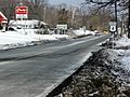
This picture shows the start of US 4 in East Greenbush, New York. It connects with US 9 and US 20 here.

