
Udall, Kansas facts for kids
Quick facts for kids
Udall, Kansas
|
|
|---|---|

Aerial photograph of Udall in 2015
|
|

Location within Cowley County and Kansas
|
|

|
|
| Country | United States |
| State | Kansas |
| County | Cowley |
| Founded | 1870s |
| Platted | 1881 |
| Incorporated | 1881 |
| Named for | Cornelius Udall |
| Area | |
| • Total | 0.55 sq mi (1.41 km2) |
| • Land | 0.55 sq mi (1.41 km2) |
| • Water | 0.00 sq mi (0.00 km2) |
| Elevation | 1,283 ft (391 m) |
| Population
(2020)
|
|
| • Total | 661 |
| • Density | 1,202/sq mi (468.8/km2) |
| Time zone | UTC-6 (CST) |
| • Summer (DST) | UTC-5 (CDT) |
| ZIP code |
67146
|
| Area code | 620 |
| FIPS code | 20-71950 |
| GNIS ID | 2397077 |
Udall is a small city located in Cowley County, Kansas, United States. It is known for its friendly community and its history. As of the 2020 census, about 661 people live there.
Contents
History of Udall
The first post office in Udall opened in September 1879. The city itself was planned out in 1881 by J.M. Napier and P.W. Smith. They bought land from I.N. Nelson to create the town. Udall was named after an English writer named Cornelius Udall. The very first house and store in Udall were built by D.C. Green.
The 1955 Udall Tornado
On May 25, 1955, a very powerful tornado, known as an F5 tornado, hit Udall at 10:35 p.m. This tornado was part of a larger storm system that had already caused damage in Blackwell, Oklahoma. The Udall tornado was the deadliest tornado ever to hit the state of Kansas.
The tornado was about 1,300 yards (almost a mile) wide. It destroyed nearly every building in Udall. Nothing was left untouched, including the grain elevator, the water tower, the old grade school, the new high school, and the city hall. Three churches were also destroyed. The water tower was knocked over, and streets were flooded. Cars and trucks were thrown far away and twisted into unrecognizable shapes. One pickup truck was even wrapped around a tree.
The tornado tragically killed 77 people in Udall and injured 270 others. A total of 192 buildings were destroyed, including 170 homes. About half of the families in Udall lost at least one family member in the storm.
-
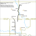
Map showing the paths of the 1955 tornadoes
-
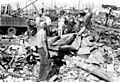
People helping clean up after the tornado
-
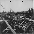
Men and a dog looking at the damage
-
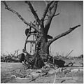
A pickup truck twisted around a tree by the tornado

.jpg)


Geography of Udall
Udall is a small city in terms of size. According to the United States Census Bureau, the city covers a total area of about 0.57 square miles (1.48 square kilometers). All of this area is land, meaning there are no large bodies of water within the city limits.
Population and People
| Historical population | |||
|---|---|---|---|
| Census | Pop. | %± | |
| 1880 | 85 | — | |
| 1890 | 338 | 297.6% | |
| 1900 | 282 | −16.6% | |
| 1910 | 330 | 17.0% | |
| 1920 | 381 | 15.5% | |
| 1930 | 436 | 14.4% | |
| 1940 | 419 | −3.9% | |
| 1950 | 410 | −2.1% | |
| 1960 | 600 | 46.3% | |
| 1970 | 668 | 11.3% | |
| 1980 | 891 | 33.4% | |
| 1990 | 824 | −7.5% | |
| 2000 | 794 | −3.6% | |
| 2010 | 746 | −6.0% | |
| 2020 | 661 | −11.4% | |
| U.S. Decennial Census | |||
.jpg)
Udall's Population in 2010
In 2010, the city of Udall had 746 people living in 289 households. About 203 of these households were families. The city had about 1,309 people per square mile.
- Many households (38.8%) had children under 18 living with them.
- Most households (51.2%) were married couples.
- About 26.3% of all households were made up of people living alone.
- Around 11.5% of people living alone were 65 years old or older.
The average age of people in Udall in 2010 was 31.7 years.
- About 30.4% of residents were under 18 years old.
- About 12.5% of residents were 65 years old or older.
- The population was slightly more female (53.6%) than male (46.4%).
Education in Udall
The public schools in Udall are part of the Udall USD 463 school district. Students in the community attend these schools.
The Udall Eagles, which is the high school's team, won the Kansas State High School class 1A volleyball championship in 1973. This was a big achievement for the school!
See also
 In Spanish: Udall (Kansas) para niños
