University Heights, Ohio facts for kids
Quick facts for kids
University Heights, Ohio
|
|
|---|---|

|
|
| Motto(s):
"City of Beautiful Homes"
|
|

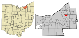
Location in Cuyahoga County and the state of Ohio
|
|
| Country | United States |
| State | Ohio |
| County | Cuyahoga |
| Area | |
| • Total | 1.83 sq mi (4.73 km2) |
| • Land | 1.83 sq mi (4.73 km2) |
| • Water | 0.00 sq mi (0.00 km2) |
| Elevation | 1,027 ft (313 m) |
| Population
(2020)
|
|
| • Total | 13,914 |
| • Density | 7,619.93/sq mi (2,941.54/km2) |
| Time zone | UTC−5 (Eastern (EST)) |
| • Summer (DST) | UTC−4 (EDT) |
| ZIP Codes |
44118, 44122
|
| Area code(s) | 216 |
| FIPS code | 39-78932 |
| GNIS feature ID | 1065413 |
University Heights is a city in Cuyahoga County, Ohio, United States. About 13,914 people lived there in 2020. It is a suburb of the Cleveland metropolitan area. The city is located about 8 miles (13 km) from downtown Cleveland.
University Heights works closely with its neighbor, Cleveland Heights. They share a school system, libraries, and even some city services. Many young people and families live here. About half of the people are under 30 years old. University Heights is next to Beachwood (east), Cleveland Heights (west), South Euclid (north), and Shaker Heights (south).
Contents
A Look Back: History of University Heights
University Heights was once part of Warrensville Township. In 1908, it became its own village called Idlewood Village.
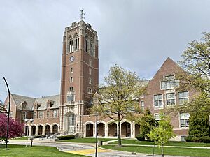
The name changed in the 1920s to University Heights. This happened because John Carroll University was planning to move there. The university's arrival helped the area grow a lot. By 1940, University Heights officially became a city.
Where is University Heights?
University Heights is located at 41.495019 degrees north and 81.536864 degrees west. The city covers about 1.82 square miles (4.7 square kilometers) of land. There is no water area within the city limits.
Two small streams, called branches of Dugway Brook, start in University Heights. They begin near the campus of John Carroll University. These streams now flow underground, hidden beneath the streets. Meadowbrook Boulevard follows where one of these streams used to flow.
Who Lives Here?
In University Heights, the average income for a household was $72,519. For families, it was $88,892. The average income per person was $30,081. A small number of people, about 6.2%, lived below the poverty line.
Most adults over 25 (67.0%) have a college degree or higher. Most people (90.2%) speak English at home. Other languages spoken include Spanish (2.1%), Yiddish (4.2%), Hebrew (1.8%), and Russian (1.7%).
People in 2010
In 2010, there were 13,539 people living in University Heights. There were 4,810 households and 3,011 families. The city had about 7,439 people per square mile.
The people living in the city were mostly White (71.8%) and African American (23.1%). Other groups included Asian (2.4%), Native American (0.1%), and people of two or more races (1.6%). About 2.8% of the population was Hispanic or Latino.
About 31.9% of households had children under 18. Many households (48.9%) were married couples. About 29.1% of households were single individuals. About 10% of people lived alone and were 65 or older. The average household had 2.48 people.
The average age in the city was 30.7 years. About 22.7% of residents were under 18. About 19.7% were between 18 and 24. The population was 47.7% male and 52.3% female.
Learning in University Heights
Public schools in University Heights are part of the Cleveland Heights-University Heights City School District. Schools located in University Heights include Gearity Early Childhood Center and Gearity Professional Development School. Cleveland Heights High School is also in the city.
There are also private schools like Gesu Catholic School. Bellefaire JCB offers preschool, childcare, and education programs for children.
University Heights is also home to John Carroll University. This is a private university with about 3,500 students. It is a Jesuit university.
See also
 In Spanish: University Heights (Ohio) para niños
 | Madam C. J. Walker |
 | Janet Emerson Bashen |
 | Annie Turnbo Malone |
 | Maggie L. Walker |

