Cleveland Heights, Ohio facts for kids
Quick facts for kids
Cleveland Heights, Ohio
|
|||
|---|---|---|---|
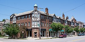
Stadium Square Historic District
|
|||
|
|||
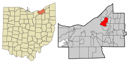
Location in Cuyahoga County and the state of Ohio.
|
|||
| Country | United States | ||
| State | Ohio | ||
| County | Cuyahoga | ||
| Founded | 1903 (Village) | ||
| Established | August 9, 1921 (City) | ||
| Government | |||
| • Type | Mayor–council | ||
| Area | |||
| • Total | 8.08 sq mi (20.94 km2) | ||
| • Land | 8.06 sq mi (20.89 km2) | ||
| • Water | 0.02 sq mi (0.05 km2) | ||
| Elevation | 942 ft (287 m) | ||
| Population
(2020)
|
|||
| • Total | 45,312 | ||
| • Estimate
(2023)
|
43,908 | ||
| • Density | 5,618.35/sq mi (2,169.15/km2) | ||
| Time zone | UTC-5 (Eastern (EST)) | ||
| • Summer (DST) | UTC-4 (EDT) | ||
| ZIP Codes |
44106, 44112, 44118, 44121
|
||
| Area code(s) | 216 | ||
| FIPS code | 39-16014 | ||
| GNIS feature ID | 1048605 | ||
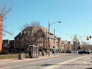
Cleveland Heights is a city in Cuyahoga County, Ohio, United States. It's known as one of Cleveland's historic streetcar suburbs. This means it was a town outside a big city where people could live and easily travel to work using electric streetcars.
Cleveland Heights started as a small village in 1903. As more people moved there, it grew into a city in 1921. In 2020, about 45,312 people lived in Cleveland Heights.
Contents
History of Cleveland Heights
The land where Cleveland Heights is today sits on top of something called the Portage Escarpment. For a long time, until the late 1800s, this area was mostly covered in trees and farms. There were also some fruit orchards, places where stone was dug up (quarries), and vineyards.
The first main road, Mayfield Road, was built in 1828. One of the early quarries was started by Duncan McFarland, who dug up a type of stone called bluestone. A small town grew around this quarry for the workers, and it was even called Bluestone. You can still find a road with that name in the area today.
Early Development and Growth
In 1873, a very rich businessman named John D. Rockefeller bought a large piece of land here. Some of this land was later used to build homes. In 1938, his family gave some of their land to the public, which is now Forest Hill Park.
Around the 1890s, electric streetcars became popular. These streetcars made it possible for people to live further away from Cleveland and still get to work easily. This led to the growth of suburbs like Cleveland Heights. A town center began to form around Mayfield and Superior roads.
In 1900, the people living in the area voted to become a "hamlet," which is a very small town. The population quickly grew to about 1,500 people. By 1903, it became a village. It kept growing fast, and by 1920, it had over 15,000 people. Because of this growth, Cleveland Heights officially became a city on August 9, 1921. Its population more than tripled between 1920 and 1930! By 1960, over 61,000 people called Cleveland Heights home.
Another important person in the city's history was railroad baron Patrick Calhoun. In 1890, he bought a large area and started a planned community called Euclid Heights in 1893. Later, in 1913, a company was formed to develop the Euclid Golf Allotment, which is now a historic area.
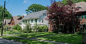
In 1926, a new business area was planned on Taylor Road. Many homes and buildings in the Tudor Revival style were built there. This area is now known as the Stadium Square Historic District.
Community and Change
In the 1950s, many Jewish families moved to Cleveland Heights from other parts of Cleveland. By 1961, a large part of the Jewish population in Cuyahoga County lived in Cleveland Heights.
Later, in the 1960s and 1970s, Black families also began to move into Cleveland Heights. This was a time of change, and some people in the community worked hard to make sure everyone felt welcome. Groups like Heights Citizens For Human Rights and Heights Community Congress were formed to help bring people together and support fairness for all citizens.
Geography
Cleveland Heights is located at 41°30′35″N 81°33′48″W / 41.50972°N 81.56333°W. The city covers about 8.13 square miles (21.06 square kilometers). Most of this area is land, with a very small amount of water.
The city has three main watersheds, which are areas where all the water drains into a common point. These are the Doan Brook Watershed, the Dugway Brook Watershed, and the Nine Mile Creek Watershed. About half of Cleveland Heights is part of the Dugway Brook Watershed.
Population Facts
| Historical population | |||
|---|---|---|---|
| Census | Pop. | %± | |
| 1910 | 2,955 | — | |
| 1920 | 15,236 | 415.6% | |
| 1930 | 50,945 | 234.4% | |
| 1940 | 54,992 | 7.9% | |
| 1950 | 59,141 | 7.5% | |
| 1960 | 61,813 | 4.5% | |
| 1970 | 60,767 | −1.7% | |
| 1980 | 56,438 | −7.1% | |
| 1990 | 54,052 | −4.2% | |
| 2000 | 49,958 | −7.6% | |
| 2010 | 46,238 | −7.4% | |
| 2020 | 45,312 | −2.0% | |
| 2023 (est.) | 43,908 | −5.0% | |
| Sources: | |||
In 2020, the 2020 United States census counted 45,312 people living in Cleveland Heights. The city is home to a diverse mix of people from different backgrounds.
The average age of people in the city was about 36 years old. Many different types of families and individuals make up the community.
Economy
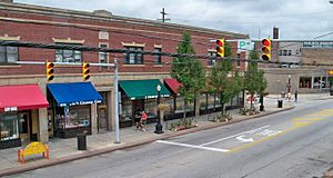
One of the most well-known business areas in Cleveland Heights is Coventry Village. It's located on Coventry Road and is famous for its artistic and musical vibe. Many creative people and unique shops can be found here.
Environment and Parks
Cleveland Heights is proud to be a nuclear-free zone, a special status it received in 1987. This means the city supports peaceful uses of energy and opposes nuclear weapons.
The city has several parks where people can relax and play. These include Barbara H. Boyd Park, Cain Park, Cumberland Park, Denison Park, Forest Hill Park, Kenilworth Park, and Turtle Park.
Transportation
Getting around Cleveland Heights is made easier by the Greater Cleveland Regional Transit Authority. They provide bus services throughout the city, helping people travel to different neighborhoods and beyond.
Education
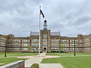
Most students in Cleveland Heights attend public schools run by the Cleveland Heights-University Heights City School District. This district has several elementary schools, two middle schools, and Cleveland Heights High School within the city limits. A small part of the city is served by the East Cleveland City School District.
There are also many private schools in Cleveland Heights, offering different types of education. Some of these include Beaumont School, Lutheran High School East, Horizon Montessori, Ruffing Montessori, Hebrew Academy of Cleveland, Communion of Saints School, Mosdos Ohr Hatorah, and Yeshiva of Cleveland.
Notable People
Many interesting and famous people have lived in Cleveland Heights! Here are just a few:
- Gina Abercrombie-Winstanley, a former U.S. Ambassador
- Martha Chase, a geneticist who helped discover that DNA carries genetic information
- Barry Cofield, an NFL player who won the Super Bowl XLII
- Chuck Cooper, a Tony Award-winning actor
- Darrell Issa, a U.S. Congressman
- Jason Kelce, a former NFL player for the Philadelphia Eagles
- Travis Kelce, an NFL player for the Kansas City Chiefs
- Bill Watterson, the cartoonist who created the famous comic strip Calvin and Hobbes
- Sean Young, an American actress
See also
 In Spanish: Cleveland Heights (Ohio) para niños
 | Jessica Watkins |
 | Robert Henry Lawrence Jr. |
 | Mae Jemison |
 | Sian Proctor |
 | Guion Bluford |


