Portage Escarpment facts for kids
The Portage Escarpment is a big natural landform in the U.S. states of Ohio, Pennsylvania, and New York. It acts like a natural border between two different types of land. To its north and west are the flatter Till Plains. To its east and south is the higher Appalachian Plateau. This escarpment is a very important part of New York's famous Finger Lakes area. Because it's close to Lake Erie, it made a good path for people to travel and build towns between New York and the Midwest.
Contents
What is the Portage Escarpment?
The Portage Escarpment is a long, sloping landform. It marks the edge where the higher Appalachian Plateau meets the flatter Till Plains. These plains are part of the Central Lowland area of the United States.
The escarpment starts in eastern New York. Experts believe it begins near Auburn, New York. As it gets closer to Buffalo, New York, it turns southwest. It then follows the shore of Lake Erie. The escarpment continues across northwest Pennsylvania, staying close to the lake.
In Ohio, the escarpment gradually moves further from the shore. Near Cleveland, Ohio, it turns sharply south. It then goes south-southwest through Ohio, Kentucky, and Tennessee. In Kentucky and Tennessee, it is known as the Highland Rim.
The name "Portage" comes from the 1750s. French explorers tried to create a "portage" (a way to carry boats over land) here. They wanted to connect their forts on the Great Lakes with their fort in Pittsburgh.
The Portage Escarpment in New York
In New York, the Portage Escarpment is made of sandstone mixed with shale. The bottom part is mostly soft, dark shale. The top part has layers of sandstone and shale. Because the hard sandstone isn't just on top, the escarpment doesn't have a sharp cliff. Instead, it looks like a slope. Sometimes, it appears as two or more parallel steps, called terraces.
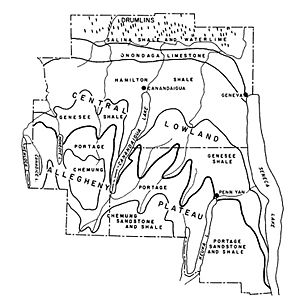
The eastern end of the escarpment is in the Finger Lakes region. It's the most important natural feature there. Before the last ice age, called the Wisconsin glaciation, about 24 large rivers flowed north over this area.
How Glaciers Shaped the Finger Lakes
The Wisconsin glaciation began around 85,000 years ago. The ice reached its furthest point about 25,000 to 21,000 years ago. The huge ice sheet could not get over the Portage Escarpment. Instead, the ice dug deep into the land. It created 11 long, deep grooves in the earth.
When the ice age ended about 10,000 years ago, these grooves filled with water. This water came from rivers flowing down the escarpment. This is how the 11 Finger Lakes were formed. The Portage Escarpment runs along the southern ends of these lakes. The glaciers and rivers also carved deep valleys. This makes the escarpment look like it weaves north and south in big loops.
The glaciers made the escarpment steeper in the Finger Lakes area than anywhere else in New York. Here, the escarpment can be about 900 to 1,000 feet (270 to 300 m) tall.
West of the Finger Lakes, the escarpment is fairly straight. The mixed sandstone and shale here has worn away a lot. In Livingston County, New York, it is not as clear or well-defined.
The Tonawanda Plain is a flat area north of the escarpment. It stretches from the eastern end to Lake Erie. This plain is bordered on the north by the Niagara Escarpment. The plain is wide near Lake Erie. But it gets much narrower along the lake's southern shore. Here, the Portage Escarpment forms its southern border. It turns southwest near Hamburg, New York, Orchard Park, New York, and East Aurora, New York.
The Portage Escarpment in Pennsylvania
The Portage Escarpment continues to follow the southern shore of Lake Erie in Pennsylvania. It goes through only Erie County, Pennsylvania. Here, it is about 2 to 4 miles (3.2 to 6.4 km) from the lake. In this area, Mississippian sandstone is more common than shale. The escarpment rises about 200 to 300 feet (61 to 91 m) high.
From Erie, Pennsylvania, to Cleveland, the escarpment is a little further from the shore. It is about 4 to 6 miles (6.4 to 9.7 km) away.
The Portage Escarpment in Ohio
In Ohio, the Portage Escarpment also helped stop the Wisconsin glaciation. The flat Erie Plain is beyond it to the northwest and west.
The escarpment stays close to Lake Erie until it reaches Cleveland. In this part, the escarpment rises in three clear steps:
- A first step, about 100 to 150 feet (30 to 46 m) above the plain.
- A second step, about 50 feet (15 m) higher than the first.
- A third step, about 300 feet (91 m) higher than the second.
In total, it ranges from 440 to 540 feet (130 to 160 m) in height. It is 2 to 4 miles (3.2 to 6.4 km) wide. This gives it a slope of 40 to 80 feet (12 to 24 m) for every 1 mile (1.6 km). East of Cleveland, much of the lower part of the escarpment is covered by glacial moraine (rock and dirt left by glaciers). Both the upper and lower parts are cut by many dry ravines, rivers, and streams. This makes the escarpment somewhat broken up. The top step of the escarpment is hard to tell apart from the Appalachian Plateau. This is because both are deeply cut by water. Where the escarpment meets the Erie Plain, it is much clearer.
Where the escarpment meets the valley of the Cuyahoga River, it bends south. It starts moving even further from the shore. It is 4 to 5 miles (6.4 to 8.0 km) from the shore between the Cuyahoga River and the Rocky River. West of the Rocky River, it is 17 miles (27 km) from the shore. Here, the escarpment rises about 200 to 300 feet (61 to 91 m) in one step. The escarpment is much lower here. This has allowed glacial till (another type of glacial deposit) to cover much of its shape. This part of the escarpment is very broken up. It is cut by the wide river valleys of the Great Miami and Scioto rivers.
Why is the Portage Escarpment Important?
The flat area between Lake Erie and the Portage Escarpment was very important. It connected the Central Lowland of the Midwest with the Mohawk Valley in the east. This was the only natural, low-lying path. It was the easiest way to travel from the Atlantic coast to the middle of North America.
Because of this, many people settled in this area. Most of Ohio was settled along the Erie Plain. People followed this natural route that was next to the Portage Escarpment. The escarpment acted as a natural barrier, guiding settlement.
 | Tommie Smith |
 | Simone Manuel |
 | Shani Davis |
 | Simone Biles |
 | Alice Coachman |


