
Rocky River (Ohio) facts for kids
Quick facts for kids Rocky River |
|
|---|---|

A shale cliff along the Rocky River in the Cleveland Metroparks Rocky River Reservation, located on the boundary of the cities of Lakewood and Rocky River, Ohio.
|
|
| Country | United States of America |
| Physical characteristics | |
| Main source | Confluence of East Branch Rocky River and West Branch Rocky River, between Cleveland and North Olmsted, Cuyahoga County, Ohio 657 feet (200 m) AMSL 41°24′23″N 81°53′14″W / 41.40639°N 81.88722°W |
| River mouth | Lake Erie between Lakewood and Rocky River, Cuyahoga County, Ohio 571 feet (174 m) AMSL 41°29′28″N 81°50′21″W / 41.49111°N 81.83917°W |
| Basin features | |
| GNIS ID | 1066928 |


The Rocky River is a river in Cuyahoga County, Ohio. It forms the natural western border for parts of Cleveland and Lakewood. On the other side, it borders Fairview Park and Rocky River. The city of Rocky River is even named after this river!
Further south, the river creates a natural boundary between Brook Park and the towns of North Olmsted and Olmsted Township. The Rocky River is famous for its excellent fishing, especially for steelhead trout. It's also a big part of the Rocky River Reservation, which is managed by the Cleveland Metroparks.
Contents
River's Journey: Where the Rocky River Begins
A river's journey starts in its watershed. This is the area of land where all the rain and snowmelt drain into a specific river or stream. The Rocky River itself begins when two smaller rivers, the East Branch and West Branch, join together. This meeting point is in North Olmsted, near Cedar Point Hill. This hill is close to the Cleveland Hopkins International Airport.
West Branch: From Medina County
The West Branch of the Rocky River starts mainly in Medina County. Here, its own north and south branches combine to form the main West Branch. This branch then flows north through towns like Olmsted Falls.
East Branch: Through Hinckley and Berea
The East Branch begins in North Royalton, a suburb of Cleveland. Interestingly, it first flows south through Richfield and Hinckley Townships. The East Branch then curves around a cool rock formation called Whipp's Ledges in Hinckley Township. After that, it turns and starts its journey north-northwest. Hinckley Lake is actually part of the East Branch, formed by a dam built in the late 1920s or early 1930s. As it continues through southwestern Cuyahoga County, the East Branch is an important feature for cities like Strongsville and Berea.
Rocky River Valley: A Green Oasis
The lower parts of both the East and West Branches, and the main Rocky River, flow through a deep, V-shaped valley. This valley and the river are part of the Cleveland Metroparks system. The Rocky River valley is covered in thick forests. A special parkway runs along the river, giving people easy access to many fun activities in the park.
Because Cleveland and its older suburbs are very crowded, the valley offers a popular place for outdoor fun. It's a great spot for activities that might be hard to do in other parts of the city.
River Health: Understanding Pollution
The Rocky River is mostly clean from industrial pollution. This is because most of its water comes from farms and suburban areas. However, this can lead to natural organic pollution and waste from homes. This can cause higher levels of bacteria in the river compared to rivers that have industrial waste.
Crossing the River: Bridges and Roads
The Rocky River valley is quite deep, especially from where the East and West Branches meet all the way to Lake Erie. In some places, the valley can be about 150 feet (46 meters) lower than the ground on either side. Because of this deep valley, many bridges have been built to cross the river. These bridges connect areas like Lakewood and Rocky River, and Cleveland and Fairview Park.
Some of the bridges that are lower down in the valley can get closed. This happens during and after heavy storms when the river water rises and floods them. However, these low-level bridges are mostly used by local traffic on the Valley Parkway, which follows the river's path and crosses it several times.
Images for kids
-
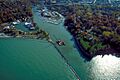
Aerial view of the river's mouth and surrounding area of discharge into Lake Erie, in Rocky River.
-
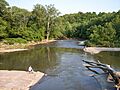
A bend in the Rocky River and adjoining riverbanks are seen in this photo taken from a bridge on the Cleveland-Rocky River border in the Rocky River Reservation.
-
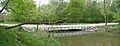
Low water ford bridge over the East Branch Rocky River in the Millstream Reservation.
