
South Euclid, Ohio facts for kids
Quick facts for kids
South Euclid, Ohio
|
|||||
|---|---|---|---|---|---|

South Euclid War Memorial
|
|||||
|
|||||

Location in Cuyahoga County and the state of Ohio.
|
|||||
| Country | United States | ||||
| State | Ohio | ||||
| County | Cuyahoga | ||||
| Euclid Township formed | 1809 | ||||
| Village incorporation | 1917 | ||||
| City incorporation | 1941 | ||||
| Government | |||||
| • Type | Mayor-council | ||||
| Area | |||||
| • Total | 4.66 sq mi (12.07 km2) | ||||
| • Land | 4.66 sq mi (12.07 km2) | ||||
| • Water | 0.00 sq mi (0.00 km2) | ||||
| Elevation | 958 ft (292 m) | ||||
| Population
(2020)
|
|||||
| • Total | 21,883 | ||||
| • Density | 4,696.93/sq mi (1,813.48/km2) | ||||
| census | |||||
| Time zone | UTC-5 (EST) | ||||
| • Summer (DST) | UTC-4 (EDT) | ||||
| Zip code |
44121
|
||||
| Area code(s) | 216 | ||||
| FIPS code | 39-73264 | ||||
| GNIS feature ID | 1049189 | ||||
| Website | https://www.cityofsoutheuclid.com/ | ||||


South Euclid is a city in Ohio, located in Cuyahoga County. It's like a neighborhood right next to Cleveland, on the east side of the city. In 2020, about 21,883 people lived there.
Contents
History of South Euclid

The land where South Euclid is today was once part of the Western Reserve. This land was obtained in 1796 through a treaty with the Iroquois people. In 1797, Moses Cleaveland named the area east of the Cuyahoga River "Euclid." He named it after the famous Greek mathematician. Euclid Township was officially created in 1809. Later, in 1828, Euclid Township was split into nine areas, and South Euclid became district two.
From Farms to Quarries
At first, farming was the main activity in the area. But by the 1860s, digging up bluestone became more important. Bluestone is a type of rock. There were two main places where bluestone was dug. One was near what is now Quarry Park. The other was along the Euclid Creek reservation. In the 1870s, these two sites joined to form the Forest City Stone Company. This company became one of the biggest bluestone producers in the region. By the late 1800s, the northern part of the town was even called "Bluestone village."
Becoming a Village and a City
People in South Euclid wanted to be independent from the larger Euclid Township. So, on October 13, 1917, they voted to become their own village. Edward C. Foote was elected as the first mayor a few weeks later. Around this time, the bluestone industry started to decline. This was because new ways of using poured concrete became popular. As a result, Bluestone village became part of South Euclid.
South Euclid continued to grow quickly in the early 1900s. This growth was partly due to industries in nearby Cleveland. During the Great Depression, the WPA helped people find jobs. This support helped the village keep growing. In 1941, South Euclid officially became a city.
After World War II, the population grew even faster. This was because of the baby boom and people moving from Cleveland. South Euclid's population was highest in the early 1970s. By 1980, there wasn't much empty land left for building. Also, people started moving to areas further from the city. Because of this, South Euclid's population began to get smaller.
Geography and Location
South Euclid is located in the eastern part of the Greater Cleveland area. It shares borders with several other cities. These include Cleveland, Cleveland Heights, University Heights, Beachwood, Lyndhurst, Richmond Heights, and Euclid.
The United States Census Bureau says that South Euclid covers about 4.65 square miles (12.07 square kilometers) of land. There is no water area within the city limits.
People of South Euclid
South Euclid is known for being a racially integrated city. This means people from many different backgrounds live there. Like its neighbors Cleveland Heights and University Heights, South Euclid has a diverse population. Many residents are African-Americans, Italian-Americans, and Jewish people. There are also immigrants from Russia and other countries that were once part of the Soviet Union.
Population Changes Over Time
The city's population has changed over the years:
- 1920: 1,605 people
- 1930: 4,399 people
- 1940: 6,146 people
- 1950: 15,432 people
- 1960: 27,659 people
- 1970: 29,579 people
- 1980: 25,713 people
- 1990: 23,866 people
- 2000: 23,537 people
- 2010: 22,295 people
- 2020: 21,883 people
Languages and Income
In 2010, most people in South Euclid (89.9%) spoke English at home. Other languages spoken included Russian (3.2%), Spanish (1.7%), Italian (1.2%), and Yiddish (1.0%).
The average income for a household in the city was about $59,423. For families, the average income was $72,340. The per capita income (income per person) was $27,343. About 9.3% of the population lived below the poverty line. This included 10.1% of people under 18.
Many adults in South Euclid have a good education. About 37.9% of people over 25 years old have a bachelor's degree or higher.
City Demographics in 2010
In 2010, there were 22,295 people living in South Euclid. There were 8,913 households and 5,791 families. The city had about 4,795 people per square mile.
The racial makeup of the city was:
- 54.1% White
- 40.7% African American
- 0.1% Native American
- 2.0% Asian
- 0.7% from other races
- 2.5% from two or more races
- Hispanic or Latino people made up 2.0% of the population.
About 32.6% of households had children under 18. The average household had 2.43 people, and the average family had 3.04 people. The average age in the city was 37.9 years. About 24% of residents were under 18.
Culture and Landmarks

The historic William E. Telling mansion is a famous building in South Euclid. It is listed on the National Register of Historic Places. For a long time, this mansion was home to the South Euclid-Lyndhurst branch of the Cuyahoga County Public Library. A part of the building, which used to be the gardener's home, now holds the South Euclid - Lyndhurst Historical Society.
In 2012, the library decided to sell the mansion and move to a new building. In 2013, the mansion was sold to an investor. Today, the mansion is home to the Museum of American Porcelain Art.
Parks and Fun Activities

South Euclid has four public parks owned by the city: Quarry, Victory, Bexley, and Oakwood.
- Quarry Park is split into North and South sections. It has a splash/sprinkle park for kids.
- Victory Park has sand volleyball courts.
- Bexley Park has a swimming pool.
- All four parks have playground equipment. You can also have picnics at all of them. Bexley's pavilion and Quarry North have grilling areas.
Quarry and Bexley parks have baseball fields. These fields are used by the city's baseball and softball leagues. Quarry Park North also has a special fenced-off dog park. Here, dogs can play without leashes, and there's a separate area for smaller dogs.
A part of the Cleveland Metroparks' Euclid Creek reservation is located in South Euclid. Nearby, the South Euclid War Memorial lists the names of people who died serving in wartime.
South Euclid also works with the nearby city of Lyndhurst to create sports groups. These include clubs for soccer, youth football, youth softball and baseball, and basketball. South Euclid is a good city for walking, ranking 10th among the largest cities in Ohio for walkability.
Education in South Euclid
The South Euclid-Lyndhurst City School District serves the city's students. It includes three elementary schools, one upper elementary school, one junior high school, and Charles F. Brush High School. South Euclid was also home to Regina High School from 1954 to 2010. That building was later bought by Notre Dame College. A small part of South Euclid is in the Cleveland Heights-University Heights City School District.
There are also private schools in South Euclid:
- St. John's: A Lutheran elementary school on Mayfield Road, which opened in the mid-1850s.
- The Lyceum: A Catholic school for both boys and girls. It prepares students for college with a classical curriculum for grades seven through twelve.
- Notre Dame College: A Roman Catholic college located on Green Road. It was founded in 1922 as a college only for women. In January 2001, it became a coed college, meaning both men and women can attend. Notre Dame College also offers online degree programs.
The Japanese Language School of Cleveland (JLSC) used to hold its weekend classes at Regina High School. This school helps Japanese nationals and Japanese Americans learn Japanese.
Famous People from South Euclid
- Steve Stone: A sports broadcaster and former baseball player. He was an MLB All-Star pitcher and won the Cy Young Award in 1980.
- David S. Ward: A screenwriter and director. He is known for movies like The Sting (1973), Major League (1989), and Sleepless in Seattle (1993).
- Carl E. Walz: A retired NASA astronaut.
Images for kids
-
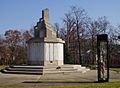
South Euclid War Memorial
-
Flag of South Euclid, Ohio
-
Seal of South Euclid, Ohio
-

Logo of South Euclid, Ohio
-
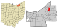
Location in Cuyahoga County and the state of Ohio.
See also
 In Spanish: South Euclid (Ohio) para niños
