
Untersiggenthal facts for kids
Quick facts for kids
Untersiggenthal
|
||
|---|---|---|
_IMG_6781.JPG) |
||
|
||

Untersiggenthal
Location in Switzerland

Untersiggenthal
Location in Canton of Aargau
|
||
| Country | Switzerland | |
| Canton | Aargau | |
| District | Baden | |
| Area | ||
| • Total | 8.28 km2 (3.20 sq mi) | |
| Elevation | 375 m (1,230 ft) | |
| Population
(Dec 2020 )
|
||
| • Total | 7,229 | |
| • Density | 873.1/km2 (2,261.2/sq mi) | |
| Postal code |
5417
|
|
| Surrounded by | Brugg, Gebenstorf, Obersiggenthal, Turgi, Villigen, Würenlingen | |


Untersiggenthal is a small town, also called a municipality, in Switzerland. It is part of the Baden district in the canton of Aargau. You can find it in the beautiful Limmat Valley.
Contents
Geography of Untersiggenthal
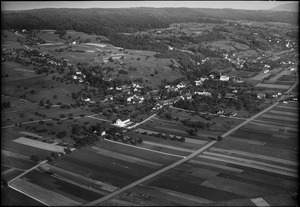
Untersiggenthal covers an area of about 8.3 square kilometers (3.2 square miles). A large part of this land, about 44%, is covered by forests. Around 33% of the land is used for farming. The rest of the area includes buildings, roads, and some non-productive land like rivers.
The Coat of Arms
The official symbol of Untersiggenthal is its coat of arms. It shows two silver keys crossed over each other on a red background. This design is called Gules two Keys in saltire Argent. It's a unique way to identify the town.
People and Population
Untersiggenthal is home to over 7,000 people. Many different nationalities live here, with about 26% of the population being foreign nationals. The town has grown steadily over the last ten years.
Most people in Untersiggenthal speak German, which is the main language. Italian is the second most common language, followed by Albanian.
The population includes many young people. About 10.7% of the residents are children aged 0 to 9 years old. Teenagers, aged 10 to 19, make up about 11.9% of the population.
In 2008, there were over 2,700 homes and apartments in Untersiggenthal. About 38% of these were single-family homes. The average household had about 2.45 people living in it.
When it comes to education, many adults in Untersiggenthal have completed higher education. This includes either a university degree or a specialized college degree. In the 2008/2009 school year, hundreds of students attended primary and secondary schools in the municipality.
Here's how the population has changed over the years:
| Historical population | ||
|---|---|---|
| Year | Pop. | ±% |
| 1975 | 4,155 | — |
| 1980 | 4,588 | +10.4% |
| 1990 | 5,338 | +16.3% |
| 2000 | 6,092 | +14.1% |
Important Historical Sites

Untersiggenthal has some important historical places. These are called heritage sites of national significance. One such site is the ruined Freudenau castle. Another is an ancient settlement called Heidenküche, which dates back to the neolithic (New Stone Age) and Bronze Age.
Economy and Jobs
In Untersiggenthal, many people have jobs in different areas.
- The primary sector involves farming and natural resources.
- The secondary sector includes manufacturing and construction.
- The tertiary sector focuses on services, like shops, offices, and healthcare.
Most jobs in Untersiggenthal are in the service sector. Many residents also travel outside the town for work. About 25% of workers use public transportation, while nearly 47% drive their own cars to work.
Religions in Untersiggenthal
According to a census from 2000, the main religions in Untersiggenthal are Roman Catholic and Swiss Reformed Church. About 47.6% of the population is Roman Catholic. Around 28.2% belong to the Swiss Reformed Church. A small number of people also follow the Christian Catholic faith.
See also
 In Spanish: Untersiggenthal para niños
