
Unterstammheim facts for kids
Quick facts for kids
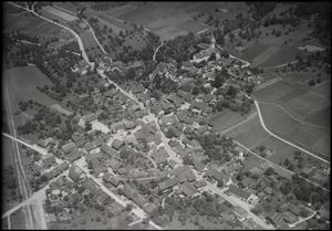
Unterstammheim
|
||
|---|---|---|
_286.JPG) |
||
|
||

Unterstammheim
Location in Switzerland

Unterstammheim
Location in Canton of Zurich
|
||
| Country | Switzerland | |
| Canton | Zurich | |
| District | Andelfingen | |
| Area | ||
| • Total | 7.32 km2 (2.83 sq mi) | |
| Elevation | 433 m (1,421 ft) | |
| Population
(December 2020)
|
||
| • Total | 928 | |
| • Density | 126.78/km2 (328.3/sq mi) | |
| Postal code |
8476
|
|
| Surrounded by | Basadingen-Schlattingen (TG), Diessenhofen (TG), Oberstammheim, Wagenhausen (TG), Waltalingen | |

Unterstammheim used to be a town, or 'municipality,' in Switzerland. It was located in the Andelfingen area, within the Zürich region. On January 1, 2019, Unterstammheim joined with two other towns, Oberstammheim and Waltalingen, to form a new, bigger town called Stammheim.
About the Area

Unterstammheim covers an area of about 7.3 square kilometers. This is roughly 2.8 square miles.
Most of the land, about 53%, is used for farming. Forests cover about 36% of the area. Around 11% of the land has buildings or roads. A very small part, less than 1%, is made up of things like rivers.
People and Life
Unterstammheim had a population of about 900 people. Most people in the town spoke German. A smaller number of people spoke Albanian or Portuguese.
In 2007, the most popular political party in elections was the SVP.
About 30% of the people living in Unterstammheim were children and teenagers. Around 56% were adults, and about 14% were seniors. Many adults in Unterstammheim, about 84%, had finished high school or gone on to higher education.
The town had a low unemployment rate, meaning most people who wanted to work had jobs. Many people worked in farming. Others worked in manufacturing or service jobs.
Getting Around
The Stammheim railway station is located in Unterstammheim. This station is part of the Zurich S-Bahn train system. You can take the S29 train line from here. It connects towns like Winterthur and Stein am Rhein.
See also
 In Spanish: Unterstammheim para niños
