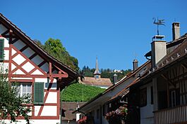
Oberstammheim facts for kids
Quick facts for kids
Oberstammheim
|
||
|---|---|---|
 |
||
|
||
| Country | Switzerland | |
| Canton | Zürich | |
| District | Andelfingen | |
| Area | ||
| • Total | 9.36 km2 (3.61 sq mi) | |
| Elevation | 440 m (1,440 ft) | |
| Population
(December 2020)
|
||
| • Total | 1,164 | |
| • Density | 124.36/km2 (322.09/sq mi) | |
| Postal code |
8477
|
|
| Surrounded by | Hüttwilen (TG), Neunforn (TG), Unterstammheim, Wagenhausen (TG), Waltalingen | |
Oberstammheim was a small town, also known as a municipality, in the canton of Zürich in Switzerland. It was located in the Andelfingen district.
On January 1, 2019, Oberstammheim joined with two other nearby towns, Unterstammheim and Waltalingen. Together, they formed a new, larger municipality called Stammheim.
Contents
History of Oberstammheim
In 2009, scientists who study old things (archaeologists) made an exciting discovery in Oberstammheim! They found an ancient burial mound, called a tumulus, from the Iron Age. This was a time long ago when people used iron tools.
This mound seemed to be the grave of an important Celtic leader or nobleman. The Celts were a group of people who lived in Europe many centuries ago. While similar discoveries have been made in Germany, this site was special because it was the only one of its kind found in Switzerland.
The name Oberstammheim was first written down in the year 761 as Stamhaim. Later, in 1212, it was mentioned as in Stamehein superiori.
Geography of Oberstammheim
Oberstammheim covers an area of about 9.4 square kilometers (about 3.6 square miles). A large part of this land, about 54.9%, is used for farming. Forests cover another 36.7% of the area. The rest of the land, about 8.2%, has buildings or roads on it. A very small part (0.2%) is made up of things like rivers.
The town is located in an area called the Züricher Weinland, which means "Zürich Wine Country." It is near the border with the canton of Thurgau. Oberstammheim is on the southern side of a hill called the Stammerberg.
The municipality included the main village of Oberstammheim. It also included the part of a tiny village, or hamlet, called Wilen bei Neunforn that was in Zürich. For a short time, from 1853 to 1886, Wilen bei Neunforn was its own independent municipality.
People of Oberstammheim
Oberstammheim had a population of 1,164 people. About 5.7% of the people living there were from other countries. Over ten years, the population grew by about 2.4%.
Most people in Oberstammheim (about 97.2%) spoke German. A smaller number spoke French (0.7%) or Italian (0.7%).
In the 2007 elections, the most popular political group was the SVP. Other popular groups included the FDP, the SPS, and the Green Party.
Looking at the ages of the people in 2000:
- Children and teenagers (0–19 years old) made up 28.6% of the population.
- Adults (20–64 years old) made up 53.5%.
- Seniors (over 64 years old) made up 18%.
In Oberstammheim, about 85% of adults (between 25 and 64 years old) had finished a good level of education. This included either high school or higher education like a university or a specialized college.
The unemployment rate in Oberstammheim was very low, at 0.68%. This means very few people who wanted to work did not have a job.
In 2005, people worked in different types of jobs:
- About 93 people worked in the primary economic sector, which means jobs like farming. There were 34 businesses in this area.
- About 56 people worked in the secondary sector, which includes jobs like manufacturing and building. There were 13 businesses in this area.
- About 213 people worked in the tertiary sector, which includes jobs like services, shops, and offices. There were 34 businesses in this area.
The table below shows how the population of Oberstammheim changed over many years:
| year | population |
|---|---|
| 1467 | 44 Households |
| 1637 | 359 |
| 1663 | 577 |
| 1695 | 529 |
| 1746 | 587 |
| 1850 | 989 |
| 1900 | 818 |
| 1950 | 758 |
| 2000 | 1,064 |
Transport
The Stammheim railway station is located in the nearby town of Unterstammheim. This station is served by the Zürich S-Bahn line S29. This train line connects the cities of Winterthur and Stein am Rhein.
Images for kids
See also
 In Spanish: Oberstammheim para niños
 | Jessica Watkins |
 | Robert Henry Lawrence Jr. |
 | Mae Jemison |
 | Sian Proctor |
 | Guion Bluford |


