Utah State Route 18 facts for kids
Quick facts for kids
State Route 18 |
||||
|---|---|---|---|---|
| Legacy Loop Highway | ||||
|
SR-18 highlighted in red
|
||||
| Route information | ||||
| Defined by Utah Code §72-4-107 | ||||
| Maintained by UDOT | ||||
| Length | 51.005 mi (82.085 km) | |||
| Existed | 1918 as a state highway; 1927 as SR-18–present | |||
| Major junctions | ||||
| South end | ||||
| Location | ||||
| Counties: | Washington, Iron | |||
| Highway system | ||||
| State highways in Utah Interstate • US • State
|
||||
State Route 18 (SR-18) is an important state highway in southern Utah. It stretches for about 51 miles (82 kilometers) through Washington and Iron Counties. The road starts in St. George and ends at Beryl Junction.
SR-18 is also part of something called the Legacy Loop Highway. This longer route connects St. George to Parowan. Interestingly, SR-18 follows a very old path. It closely matches the route of the historic Old Spanish Trail as it goes through the beautiful Dixie National Forest.
Contents
What is State Route 18 Like?
SR-18 travels through different kinds of landscapes, from busy city areas to quiet forests. Let's explore its journey!
From St. George to Veyo
SR-18 begins in St. George, a city in southern Utah. It starts near the I-15 highway. Here, it acts like a main city road, helping people get around the west side of downtown St. George.
As you drive north, SR-18 passes by other important roads like Sunset Boulevard (SR-8). It also has special intersections designed to help traffic flow smoothly. These include an "inverted single-point urban interchange" and a "dumbbell interchange."
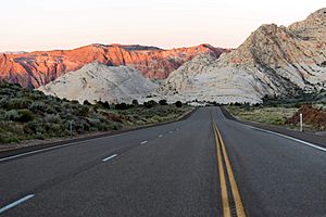
The highway then goes through Snow Canyon State Park, which is known for its amazing red rock formations. After leaving the park, SR-18 continues through Wide Canyon. It passes by places like Dammeron Valley and the Veyo Volcano. Finally, it reaches the town of Veyo, running right through its center. This part of SR-18 is considered a very important road for the country's transportation system.
From Veyo to Beryl Junction
After leaving Veyo, SR-18 heads northeast towards a small community called Central. The road then turns north and northwest. It travels through mountains and parts of the Dixie National Forest.
Along this section, you'll pass near the Mountain Meadows Massacre site. This is a historic location. The highway then continues into the town of Enterprise.
In Enterprise, SR-18 turns northeast and then north again. It goes through farmlands outside the town. The journey ends at Beryl Junction. Here, SR-18 meets another state highway, SR-56.
History of SR-18
The path that SR-18 follows has a long and interesting history. It closely matches a very old trade route called the Old Spanish Trail. This trail was used a long time ago for trading goods.
A significant historical event happened near this route in 1857. It was called the Mountain Meadows Massacre. This event is an important part of Utah's history. The location of this event is just off what is now SR-18.
The road that became SR-18 was first added to Utah's state highway system in 1918. At that time, it connected a place called Enterprise Junction to Modena. In 1927, the road officially received the number SR-18. Over the years, different parts of the road were added or changed. For example, in 1935, a section from Beryl Junction to Nevada became part of another highway, SR-56. Later, in 1969 and 1974, SR-18 was extended south into St. George, connecting to the major Interstate 15.
Main Road Crossings
Here are some of the main roads that SR-18 crosses or connects with along its way:
| County | Location | Mile | Roads intersected | Notes | |
|---|---|---|---|---|---|
| Washington | Saint George | 0.000 | 0.000 | Frontage Road | This is where SR-18 begins in the south. |
| 0.043– 0.289 |
0.069– 0.465 |
You can get on or off I-15 at Exit 6 here. | |||
| 2.103 | 3.384 | SR-34 east (Saint George Boulevard) | This used to be part of the old US-91 highway. | ||
| 3.181 | 5.119 | SR-8 west (Sunset Boulevard) | This also used to be part of the old US-91 highway. | ||
| 3.844 | 6.186 | Snow Canyon Parkway/Red Hills Parkway – Snow Canyon State Park | This is a special type of intersection called an "inverted single-point urban interchange." | ||
| 8.751 | 14.083 | Ledges Parkway | This is another special intersection called a "dumbbell interchange." | ||
| Enterprise | 40.338 | 64.918 | This road was once known as SR-120. | ||
| Iron | Beryl Junction | 51.005 | 82.085 | SR-56 – Modena, Cedar City | This is where SR-18 ends in the north. |
| 1.000 mi = 1.609 km; 1.000 km = 0.621 mi | |||||
 | Valerie Thomas |
 | Frederick McKinley Jones |
 | George Edward Alcorn Jr. |
 | Thomas Mensah |


