Valley Falls, Oregon facts for kids
Quick facts for kids
Valley Falls, Oregon
|
|
|---|---|

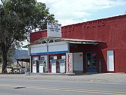
Valley Falls store and gas station
|
|
| Country | United States |
| State | Oregon |
| County | Lake |
| Elevation | 4,327 ft (1,319 m) |
| Time zone | UTC-8 (Pacific) |
| • Summer (DST) | UTC-7 (Pacific) |
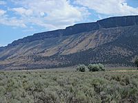
Valley Falls is a tiny place in Lake County, Oregon, USA. It's not a city, but a small community without its own government. You can find it where two main roads, U.S. Route 395 and Oregon Route 31, meet. The name 'Valley Falls' comes from a small waterfall on the Chewaucan River nearby. To the east, a huge cliff called Abert Rim towers over the area.
Contents
History of Valley Falls
Early Native American Life
Long, long ago, about 11,000 years, Native American tribes lived around Valley Falls. They used this area a lot between 2,000 and 500 years ago. These people were likely ancestors of the Klamath and Modoc tribes. They often lived in special 'pit-houses' near Abert Lake, just north of Valley Falls.
You can still see ancient rock carvings, called petroglyphs, near Valley Falls. The ones at the Abert Lake Petroglyphs, at the foot of Abert Rim, might be over 10,000 years old!
Explorers and Settlers
In 1832, a fur trader named John Work traveled through this area. He was part of the Hudson's Bay Company and wrote about his visit in his journal. Later, in 1843, Captain John C. Fremont explored the Valley Falls area. He named Abert Rim and Abert Lake after Colonel John James Abert, who was a leader in the United States Army's map-making team.
Founding the Community
The community of Valley Falls was started by C. W. E. Jennings around 1908. He opened a store there. The name came from a small waterfall on the Chewaucan River, about 1 mile (1.6 km) north of the store.
In 1909, a post office opened in Valley Falls. It was first run by Ernest L.H. Meyer, but Jennings later took over. At its busiest, Valley Falls had a hotel, a stable for horses, and a dance hall, along with Jennings' store and the post office. There were plans for a railroad, but it was never built.
In 1942, the post office moved about 1 mile (1.6 km) west to where U.S. Route 395 and Oregon Route 31 meet. However, the Valley Falls post office closed just a year later in 1943.
Geography of Valley Falls
Valley Falls is located in the high desert part of Lake County in south-central Oregon. It's right where U.S. Route 395 and Oregon Route 31 cross. Today, there are only about five buildings in the area.
Valley Falls is about 23 miles (37 km) north of Lakeview, Oregon, on Route 395. It's also 23 miles (37 km) southeast of Paisley, Oregon, on Route 31. If you're coming from Burns, Oregon, it's about 116 miles (187 km) southwest on Route 395.
Geology of Abert Rim
Abert Rim is a huge cliff about 1 mile (1.6 km) east of Valley Falls. It's one of the tallest escarpments (steep slopes or cliffs) in the United States. The rim rises about 2,500 feet (760 m) above the valley floor. The top 800 feet (240 m) is a straight-up cliff!
This cliff stretches for over 30 miles (48 km) from north to south. This makes it the longest exposed block fault scarp in North America. Abert Rim is made of basalt, a type of rock formed from ancient lava flows during the Miocene epoch (a long time ago!). After the lava stopped flowing, huge cracks formed in the land, tilting large blocks of earth. Abert Rim is what's left of one of these giant tilted blocks.
From Valley Falls, you get a clear view of Abert Rim's cliff face. There's a special sign along the highway just south of Valley Falls. It's part of the Outback Scenic Byway and explains how Abert Rim was formed. You can also find two more signs with geological information north of Valley Falls, one on Route 395 and another on Route 31.
Climate in Valley Falls
Valley Falls has a dry climate, typical of Oregon's high desert. The average high temperature for the year is about 61.8°F (16.6°C). July is usually the warmest month, with temperatures averaging over 86°F (30°C). The hottest temperature ever recorded was 105°F (41°C) in 1961.
The average low temperature for the year is about 31.1°F (-0.5°C). January is usually the coldest month, averaging 22°F (-6°C). The coldest temperature ever recorded was -34°F (-37°C) in 1962.
Valley Falls gets about 13 inches (33 cm) of rain each year. Most of the rain falls between October and June, often from thunderstorms. From November to March, most of the precipitation comes as snow.
| Climate data for Valley Falls, Oregon | |||||||||||||
|---|---|---|---|---|---|---|---|---|---|---|---|---|---|
| Month | Jan | Feb | Mar | Apr | May | Jun | Jul | Aug | Sep | Oct | Nov | Dec | Year |
| Mean daily maximum °F (°C) | 41.3 (5.2) |
44.9 (7.2) |
51.9 (11.1) |
57.1 (13.9) |
67.3 (19.6) |
77.2 (25.1) |
86.2 (30.1) |
84.7 (29.3) |
75.4 (24.1) |
63.3 (17.4) |
50.1 (10.1) |
41.3 (5.2) |
61.8 (16.6) |
| Daily mean °F (°C) | 31.7 (−0.2) |
33.9 (1.1) |
38.7 (3.7) |
42.9 (6.1) |
50.8 (10.4) |
58.5 (14.7) |
66.1 (18.9) |
64.2 (17.9) |
55.7 (13.2) |
46.5 (8.1) |
37.6 (3.1) |
30.4 (−0.9) |
46.5 (8.1) |
| Mean daily minimum °F (°C) | 22.1 (−5.5) |
22.9 (−5.1) |
25.4 (−3.7) |
28.7 (−1.8) |
34.3 (1.3) |
39.9 (4.4) |
46.0 (7.8) |
43.8 (6.6) |
36.1 (2.3) |
29.7 (−1.3) |
25.0 (−3.9) |
19.4 (−7.0) |
31.1 (−0.5) |
| Average precipitation inches (mm) | 1.5 (38) |
1.4 (36) |
1.0 (25) |
1.0 (25) |
1.5 (38) |
1.2 (30) |
0.4 (10) |
0.3 (7.6) |
0.6 (15) |
1.0 (25) |
1.2 (30) |
1.4 (36) |
12.5 (320) |
| Source: National Climatic Data Center (temperature) and Western Regional Climate Center (precipitation) | |||||||||||||
Local Points of Interest
If you visit Valley Falls, here are some interesting places nearby:
- Abert Rim
- Abert Lake
- Abert Lake Petroglyphs (these ancient rock carvings are listed on the National Register of Historic Places)
- Chandler State Wayside
- Chewaucan River
- Oregon Outback Byway
 | Audre Lorde |
 | John Berry Meachum |
 | Ferdinand Lee Barnett |


