
Vayas, Ponce facts for kids
Quick facts for kids
Vayas
|
|
|---|---|
.jpg)
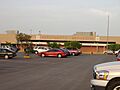
Tower at Mercedita Airport in Vayas
|
|

Location of Vayas barrio within the municipality of Ponce shown in red
|
|

Vayas, Ponce
Location in Caribbean
|
|
| Commonwealth | |
| Municipality | |
| Area | |
| • Total | 10.44 sq mi (27.0 km2) |
| • Land | 7.09 sq mi (18.4 km2) |
| • Water | 3.35 sq mi (8.7 km2) |
| Elevation | 0 ft (0 m) |
| Population
(2010)
|
|
| • Total | 901 |
| • Density | 127.1/sq mi (49.1/km2) |
| Source: 2010 Census | |
| Time zone | UTC−4 (AST) |
Vayas is a special area called a barrio in the municipality of Ponce, Puerto Rico. It is one of 31 barrios in Ponce. Vayas is also one of the five barrios in Ponce that are located right on the coast, meaning it touches the Caribbean Sea. The other coastal barrios are Playa, Bucana, Canas, and Capitanejo. Vayas is also considered a rural coastal barrio. It was first set up in 1831. At that time, it was split into two parts, Vayas Norte and Vayas Sur, but they were later joined together to form the Vayas we know today.
Contents
History of Vayas Barrio
Vayas is one of the oldest barrios in Ponce. Its history goes back to the 1780s. The name "Vayas" has been spelled in different ways over time, like "Bayas" or "Vallas." Today, the official spelling is "Vayas." People believe the name comes from the "stakes" or "fences" that farmers used long ago. These stakes helped them mark the edges of their land, especially when they used the land for grazing animals.
Where is Vayas Located?
Vayas is a rural area located along the coast in the southern part of Ponce. It is east of downtown Ponce and southeast of the main city center, Plaza Las Delicias. The area is mostly flat, with an elevation of about 43 feet above sea level. The name "Vayas" is connected to the idea of boundaries or fences that mark off a land area.
Vayas Boundaries and Neighbors
Vayas has clear borders. To the north, it is bordered by PR-1 and La Esperanza Street. The Caribbean Sea forms its southern border. To the west, it is next to Bucara Street/Los Caobos Avenue, PR-52, and the Costa Caribe Country Club East Access Road. The Río Inabón forms its eastern boundary.
When looking at its neighbors, Vayas is bordered by Sabanetas and Coto Laurel to the north. The Caribbean Sea is to its south. To the west, it borders Bucaná, and to the east, it borders Capitanejo.
Facts and Population of Vayas
Unlike many other parts of Ponce, the land in Vayas is completely flat. Vayas has the third-longest coastline among Ponce's five coastal barrios. Only Canas and Playa have longer coastlines. Vayas covers about 7.1 square miles of land and 3.4 square miles of water.
In the year 2000, Vayas had a population of 1,338 people. This meant there were about 188 people living in each square mile. By 2010, the population had changed to 901 people, with about 127.1 people per square mile. The main roads that go through Vayas are PR-52 and PR-1.
| Historical population | |||
|---|---|---|---|
| Census | Pop. | %± | |
| 1910 | 720 | — | |
| 1920 | 633 | −12.1% | |
| 1930 | 790 | 24.8% | |
| 1940 | 621 | −21.4% | |
| 1950 | 1,530 | 146.4% | |
| 1960 | 1,641 | 7.3% | |
| 1970 | 1,375 | −16.2% | |
| 1980 | 1,160 | −15.6% | |
| 1990 | 1,153 | −0.6% | |
| 2000 | 1,338 | 16.0% | |
| 2010 | 901 | −32.7% | |
| U.S. Decennial Census 1899 (shown as 1900) 1910-1930 1930-1950 1960 1980-2000 2010 |
|||
Important Places in Vayas
Vayas barrio is home to some important landmarks. These include Ponce's Mercedita Airport, which is a key travel hub. It also hosts Destileria Serralles, a well-known distillery. The community of Vayas Torres is one of the neighborhoods located within Barrio Vayas.
Famous People from Vayas
- Carmín Vega is a comedian who comes from the Mercedita area of Barrio Vayas.
Images for kids
-
Mercedita Airport in Barrio Vayas

.jpg)
See also
 In Spanish: Vayas para niños
