
Vera Cruz, Missouri facts for kids
Quick facts for kids
Vera Cruz, Missouri
|
|
|---|---|
|
Community
|
|

The old log church in Vera Cruz by the cemetery
|
|

Vera Cruz, Missouri
Location in Missouri
|
|
| Country | U. S. A. |
| State | Missouri |
| County | Douglas County |
| Elevation | 260 m (850 ft) |
| Time zone | UTC-6 (CST) |
| • Summer (DST) | UTC-5 (CDT) |
Vera Cruz is a small, unincorporated community in the middle of Douglas County, Missouri, in the United States. This means it's a group of homes and businesses that isn't officially a town or city with its own local government. It's located right by Bryant Creek, about 9 miles (14 km) east of a town called Ava. You can find it at the end of Route AB.
Contents
History of Vera Cruz
Early Days and Name Change
Vera Cruz was first settled in the 1840s. It was named after a city in Mexico called Vera Cruz. The community was originally known as Red Bud. It was an important spot because it was where two old roads met. One road went up the Bryant valley, connecting Rockbridge and Hartville. The other was called the Old Salt Road, which went northwest through Smallett to Springfield. The name of the community was officially changed to Vera Cruz in 1859.
Vera Cruz as County Seat
For a time, Vera Cruz was very important to Douglas County. It was the very first county seat of Douglas County. A county seat is the main town where the county government offices are located. However, this didn't last forever. In 1870, the county seat was moved to a place called Arno. Soon after, it was moved again to the town of Ava, where it remains today.
Civil War Battles Near Vera Cruz
During the American Civil War, two battles took place close to Vera Cruz. The first battle, known as the Battle of Clark's Mill, happened on November 7, 1862. It took place at a mill on Bryant Creek, about 1 mile (1.6 km) north of where Vera Cruz is now.
Another battle occurred on November 3, 1864. This fight happened near Wilson's Mill. During this battle, soldiers from the Confederate side were forced to leave the area. These events show that Vera Cruz and its surroundings were important during the Civil War.
Gallery
-
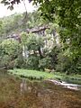
Hunter Creek bluff above the old mill pond at Vera Cruz, Missouri
-
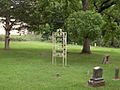
The cemetery in Vera Cruz, Missouri


