Hartville, Missouri facts for kids
Quick facts for kids
Hartville, Missouri
|
|
|---|---|
| City of Hartville | |

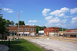
Businesses at the intersection of Main and Rolla
|
|

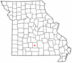
Location of Hartville, Missouri
|
|
| Country | United States |
| State | Missouri |
| County | Wright |
| Area | |
| • Total | 0.66 sq mi (1.72 km2) |
| • Land | 0.65 sq mi (1.69 km2) |
| • Water | 0.01 sq mi (0.03 km2) |
| Elevation | 1,191 ft (363 m) |
| Population
(2020)
|
|
| • Total | 594 |
| • Density | 911.04/sq mi (351.90/km2) |
| Time zone | UTC-6 (Central (CST)) |
| • Summer (DST) | UTC-5 (CDT) |
| ZIP code |
65667
|
| Area code(s) | 417 |
| FIPS code | 29-30754 |
| GNIS feature ID | 0719185 |
Hartville is a small city in Missouri, United States. It is the county seat of Wright County. This means it's the main town where the county government is located. In 2020, about 594 people lived in Hartville.
Contents
History of Hartville
Hartville has had a post office since 1842. People started living here in the early 1800s. The town is named after Isaac Hart, an early settler.
A big battle, called the Battle of Hartville, happened here in 1863 during the American Civil War. Much of the town was destroyed. A Confederate officer named Lt. Col. John Wimer was killed in this battle. He had been the mayor of St. Louis two times. He was buried in Hartville.
In 1959, a strong tornado, known as the Grovespring Tornado, hit Hartville. It destroyed most of the town's business area, including the post office. Luckily, a warning alarm went off, giving people time to find shelter. Because of this, no one was seriously hurt.
The Kelton House is an important old building in Hartville. It was added to the National Register of Historic Places in 1983. This list includes places that are important to the history of the United States.
In 2020, Hartville was found to be the closest place to the mean center of the United States population. This means if you imagine all the people in the U.S. standing on a map, and you found the exact balancing point, that point would be near Hartville.
Geography of Hartville
Hartville is located where Missouri routes 5 and 38 meet. It's also near the Wood's Fork of the Gasconade River. This river flows into the larger Gasconade River just east of the town.
According to the United States Census Bureau, Hartville covers a total area of about 0.66 square miles (1.72 square kilometers). Most of this area, about 0.65 square miles (1.69 square kilometers), is land. Only a small part, about 0.01 square miles (0.03 square kilometers), is water.
As mentioned, the mean center of the United States population in 2020 was about 15 miles (24 kilometers) northeast of Hartville.
Population and People
| Historical population | |||
|---|---|---|---|
| Census | Pop. | %± | |
| 1880 | 248 | — | |
| 1900 | 445 | — | |
| 1910 | 507 | 13.9% | |
| 1920 | 521 | 2.8% | |
| 1930 | 453 | −13.1% | |
| 1940 | 393 | −13.2% | |
| 1950 | 526 | 33.8% | |
| 1960 | 486 | −7.6% | |
| 1970 | 524 | 7.8% | |
| 1980 | 576 | 9.9% | |
| 1990 | 495 | −14.1% | |
| 2000 | 607 | 22.6% | |
| 2010 | 613 | 1.0% | |
| 2020 | 594 | −3.1% | |
| U.S. Decennial Census | |||
2010 Census Information
In 2010, there were 613 people living in Hartville. These people lived in 232 households, and 133 of these were families. The city had about 943 people per square mile (364 people per square kilometer). There were also 305 housing units, like houses or apartments.
Most of the people in Hartville were White (97.9%). A small number were African American (0.5%), Native American (0.3%), or Asian (0.3%). About 1.0% of the population identified as two or more races. About 2.0% of the people were of Hispanic or Latino background.
Out of the 232 households, about 31.5% had children under 18 living with them. About 37.5% were married couples. Some households had a single female parent (14.7%) or a single male parent (5.2%). About 42.7% of households were not families.
Many households (37.9%) had only one person living in them. About 18.9% of all households had someone aged 65 or older living alone. On average, there were 2.34 people in each household and 3.17 people in each family.
The average age of people in Hartville was 38.5 years. About 26.3% of residents were under 18 years old. About 21.7% were 65 years or older. The population was almost evenly split between males (48.6%) and females (51.4%).
Education in Hartville
Public schools in Hartville are managed by the Hartville R-II School District. This district runs two elementary schools, one middle school, and Hartville High School.
Hartville also has a public library where you can borrow books. It is a branch of the Wright County Library.
Notable Person
- Walter Mitchell: He was a bishop in the Episcopal Church in Arizona.
See also
 In Spanish: Hartville (Misuri) para niños
 | Tommie Smith |
 | Simone Manuel |
 | Shani Davis |
 | Simone Biles |
 | Alice Coachman |


