
Villalbos facts for kids
| Villalbos Village | |
|---|---|
View |
Villalbos |
| Province | Burgos |
| Autonomous community | Castilla y León |
| Postal code | 09258 |
| Coordinates - Latitude: - Longitude: |
42°46' N 3º19' W |
| Altitude | 860 m |
| Area | km2 |
| Distances | 17 km to Belorado 39 km to Burgos |
| Population - Total (census of 2007) - Density |
25 inhabitants inhabitants/km2 |
| Demonym | Villalbés |
| River | Oca |
| Mayor (2007- ) | Isabel Bonilla Calleja (Partido Popular) |

Villalbos ![]() is a small village in the north-east of the Burgos Province in Spain. It is part of the Castilla y León region.
is a small village in the north-east of the Burgos Province in Spain. It is part of the Castilla y León region.
Contents
Where is Villalbos Located?
Villalbos is found on the left side of the Oca River. This river eventually flows into the larger Ebro River. The village is surrounded by beautiful natural landscapes.
How to Find Villalbos on a Map
You can locate Villalbos using these coordinates: 42°26'40"N and 3°19'47"W. These numbers help pinpoint its exact spot on a map.
What is the History of Villalbos?
Villalbos has a long history, dating back to the early 10th century. Around that time, a Castilian count named don Rodrigo Díaz started a settlement near the Oca River. He was also known as "Abolmondar Albo."
How Did Villalbos Get Its Name?
The name Villalbos comes from "Albo," part of the count's name. Another nearby town, Villalmondar, got its name from "Abolmondar." These names show the historical connection to their founder.
What is the Church of Saint Thomas Apostle Like?
The main church in Villalbos is called the Catholic Church of Saint Thomas Apostle. It is an old building that still has its original bell tower. The church is built in the shape of a Latin cross. It also has a cemetery nearby.
How Many People Live in Villalbos?
The number of people living in Villalbos has changed over time. In 2007, about 25 people lived there. You can see how the population has changed in the table below.
| 1842 | 1857 | 1860 | 1877 | 1887 | 1897 | 1900 | 1910 | 1920 | 2007 | |||||||||
|---|---|---|---|---|---|---|---|---|---|---|---|---|---|---|---|---|---|---|
| 109 | 153 | 169 | 124 | 116 | 126 | 120 | 133 | 129 | 25 |
Images for kids
-
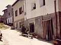
La Flor street (1986)
-
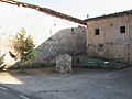
Saint Thomas Square (2008)


See also
 In Spanish: Villalbos para niños
