
Villamelendro de Valdavia facts for kids
Quick facts for kids
Villamelendro de Valdavia, Spain
|
|||
|---|---|---|---|
 |
|||
|
|||
| Country | Spain | ||
| Autonomous community | Castile and León | ||
| Province | Palencia | ||
| Municipality | Villasila de Valdavia | ||
| Area | |||
| • Total | 30.25 km2 (11.68 sq mi) | ||
| Elevation | 880 m (2,890 ft) | ||
| Population
(2011)
|
|||
| • Total | 12 | ||
| Time zone | UTC+1 (CET) | ||
| • Summer (DST) | UTC+2 (CEST) | ||


Villamelendro is a small town in Spain, located in the province of Palencia in the Castile and León region. It is part of the Villasila de Valdavia municipality. The town sits between the Natural Park Montaña Palentina and the Tierra de Campos area. It's also near the Camino de Santiago route, which historically connected San Vicente de la Barquera with Carrión de los Condes.
Villamelendro is on the right side of the Valdavia River. You can reach it by a short road called PP-2454, which connects to the main provincial road P236.
Contents
Location and Distances
Villamelendro is located in a beautiful area of Spain. Here are some distances to bigger cities:
- Distance to Palencia: 75.6 kilometers
- Distance to Burgos: 88.1 kilometers
- Distance to Valladolid: 122.0 kilometers
- Distance to León: 131.3 kilometers
- Distance to Santander: 155.6 kilometers
The Valdavia River flows through the area from north to south, with Villamelendro on its right bank.
How the Town Grew
Early Settlement
Villamelendro started around the 9th century. Its location was chosen for a few reasons:
- There were old Roman building ruins nearby.
- A fresh water spring was found, providing drinking water.
- These spots were at a crossroads of important old roads.
One road, the old road of Saldaña, came from the west. Another, the royal road of Valdavia, ran parallel to the river. The town grew along this royal road, which is now called Calle Mayor (Main Street).
Building Over Time
The town was built in two main stages:
- First Stage: The oldest part of the town is in the far north, near where the camino de Villabasta road meets Calle Sol. This area, especially where Calle Mayor and Calle Cantarranas meet, was the original settlement. It slowly expanded towards the river.
- Second Stage: Later, more houses were built south of Calle Sol. This street is now in the middle of the village, but it got its name ("Sun Street") because it was the first street to get sunlight in the morning when it was the southernmost part of town. This growth happened as the population increased and the local economy improved in the 16th and 17th centuries.
Local Roads and Bridges
The Camino Real de la Valdavia and the Camino Viejo de Saldaña were the main ways people and goods traveled to the village. The Camino Real was the most important road in the valley. For a long time, there was only a wooden bridge over the river. In 1948, a new bridge was built, and the local road was paved, making travel much easier.
Famous People from Villamelendro
- Lucas Espinosa (1895-1975): A priest and expert in languages. He was born nearby but spent a lot of time in Villamelendro. He studied the native languages of the Amazon, like Kokama, Kokamilla, and Omagua.
- Matías Santos: A doctor who studied at the Universidad de Alcalá in 1678. His old school records are still kept there.
Important Buildings
Church of Our Lady of the Assumption
The Church of Our Lady of the Assumption is a beautiful building made of brick and stone. It has a modern bell tower that replaced an older one. The entrance has a rounded arch. Inside, there is one main room with arched ceilings and a wooden choir area.
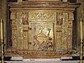
The main altarpiece, which is a large decorated screen behind the altar, is from the early 17th century. It has paintings of the Annunciation and the Adoration of the Shepherds. There are also paintings of four important Church leaders: St Augustine of Hippo, St Gregory the Great, St Ambrose of Milan, and St Jerome of Stridon. The altarpiece also features a statue of the Asunción (Assumption of Mary) and paintings of the martyrdom of Julita and Quirico. The tabernacle, where the Eucharist is kept, has a carving of the Resurrection.
Most of the church was built in the 16th century. It has had some problems over the years, needing extra supports to keep it strong. Because of these issues, the church was added to the Red List of Heritage by Hispania Nostra in 2019, meaning it needs care and protection.
-
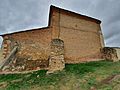
View of the back of the church.
-
The tabernacle with a carving of the Resurrection.
-
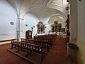
Inside the church.
-
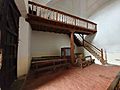
View of the choir area.
-
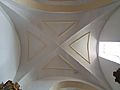
The arched ceiling inside the church.
-
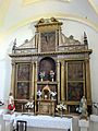
The main altarpiece.
-
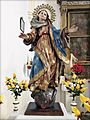
A statue of Our Lady.
-
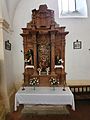
The Souls altarpiece.


Town History
_003.jpg)


Middle Ages
The first time Villamelendro was mentioned in writing was in 1175. It was called "Uilla Melendi" in a document from a monastery.
In 1180, King Alfonso VIII gave special rights (called a jurisdiction) to both Villamelendro and Villasila. This meant they had more control over their own laws.
However, just six years later, in 1186, the towns changed hands. They became a behetria, meaning they could choose their own lord. Pedro Rodríguez de Castro became their lord.
In 1189, Pedro Rodríguez de Castro and his wife gave Villamelendro and Villasila to the Order of Santiago, a powerful knightly order. They were allowed to keep the towns during their lifetime, but after they died, the towns would belong fully to the Order.
From Lords to Monasteries
After Pedro Rodríguez de Castro died, King Alfonso VIII confirmed the donation of Villamelendro and Villasila to the Order of Santiago in 1194. This made both villages into abadengo towns, meaning they were under the control of a monastery or religious order.
From then on, the towns were connected to the hospitals of Las Tiendas and Villamartin, which were run by the Order of Santiago. Many records show contributions and payments related to these hospitals.
For example, in 1231, two brothers, D. Alfonso Martínez and Don García Martínez, gave their properties in Villamelendro and other towns to the Villamartin Hospital. This was to create an "anniversary" (a yearly remembrance) for their souls and their families.
In 1255, King Alfonso X of Castile confirmed the special rights that his great-grandfather, King Alfonso VIII, had given to the towns 75 years earlier.
In 1328, Villamelendro was again mentioned in documents from the Santa Eufemia de Cozuelos Monastery. The master of the Order of Santiago donated Villamelendro, along with other places, to the monastery to help support it.
Later History

In 1527, during a meeting of the Order of Santiago, it was noted that Villamelendro and Villasila needed to pay for silver boxes for the Blessed Sacrament in their churches.
It's interesting that in 1528, Villamelendro had 29 pechero neighbors (people who had to pay taxes to the King), while Villasila had 22. This shows that Villamelendro was quite important at the time, possibly because of its location on the main royal road.
In 1537, King Charles V, who was the administrator of the Order of Santiago, confirmed the old rights of Villamelendro and Villasila. This was needed for a legal case happening in the towns.
In the 16th century, Villamelendro had about 30 families. By 1631, a census showed that Villamelendro and Villasila together had 80 families, with many children under 10. This suggests a good period of growth and prosperity.
In 1740, there was a legal dispute about a dam and riverbed that affected irrigation and pastures shared by Villamelendro, Villasila, and Villaeles.
In 1771, a report about groups and celebrations in the region mentioned Villamelendro and Villasila. They had 4 brotherhoods and 6 holidays, with a budget for these events.
By 1789, Villamelendro and Villasila were known as "royal towns" with their own mayors. This information was used in a geography dictionary in 1795.
Modern Times

In 1828, a dictionary described Villamelendro and Villasila as royal towns with 97 families and 342 people. They had a church and a granary. The towns were located by the Valdavia River and produced grain, pasture, and livestock.
In 1845, another detailed dictionary described the towns. It noted that Villamelendro was on a small hill, a short walk from Villasila. It had 90 houses and a primary school. Both towns had a fountain for drinking water and a parish church. The land was good for farming, and the Valdavia stream provided irrigation. The area produced wheat, rye, barley, oats, chickpeas, and more. People raised sheep, cattle, and horses, and fished for trout and crabs. There were also flour mills and an oil mill.
Place Names
Water Features
Here are some names of brooks and fountains in the area:
- Brooks: Boqueras, Canalejas, Cuérnago del Molino, Cuestamañana, Franciscas, Fuentemellada, Huertas, Huerto Las Casas, Lobas, Majadillas, Matafrades, Matazalce, Orejo, Quintanillas, Romilla, Valdecabras, Valdecirbano, Valdemadre, Valdeodrés.
- Fountains: Vega, Pueblo, Escuela.
- River: Valdavia.
Hills and Paths
Here are some names of paths and mountains:
- Paths: Barriales, Campos, Fuentepedreña, Itero Seco, Landesa, Otero Nombrado, Palominas, Pepino, Rigueras, S. Andrés, Soto, Sotobañado, Camino de Dña. Olimpa, Villabasta, Villada.
- Mountains: Corrillo (990m), Lobas (990m), Morcorio (986m), Picones (985m).
Other Places
Many areas around Villamelendro have special names:
- Argañales, Arnillas, Barciganillo, Camino de Villamelendro, Canalejas, Cañadillo, Corbejones, Corrillo, Eras, Espineras, Fontecha, Franciscas, Fuentemellada, Fuentepedreña, Hazas, Hongares, Huertas, Huerto Las Casas, Landesa, Llanillos, Lobas, Manrubial, Matafrades, Matazalce, Molino del Oleo, Olmos, Orejo, Otero Nombrado, Pajariteros, Palominas, Payudos, Portilla, Quintana, Quintanas, Rabas, Ribero, Rigueras, Romilla, Soto, Tras La Iglesia, Valdecirbano, Valdemadre, Valdeodrés.
Images for kids
-
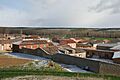
General view. 23 March 2008. Easter Sunday
-
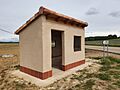
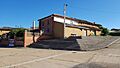
Villamelendro de Valdavia bus station at the crossroads of the provincial road P236 with the PP-2454 road, called "camino vecinal", 800 m. from the village centre.
-
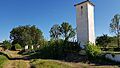
View of the hill of La Horca, with the access to the village fountain at its foot.
-
Village fountain.
-
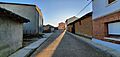
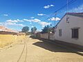
View of Sol Street. This street was the southernmost street in the primitive town centre, and the first to receive the morning rays, hence its name.
-
View of Cantarranas Street. Its name is related to its orientation towards the river, which amplified the sound made by these amphibians.
-
View of the Mayor Street. Longitudinal axis of the village and part of the Camino Real de la Valdavia as it passes through Villamelendro.
-
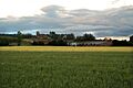
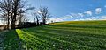
View of the village from the Vega.
-
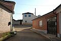
Entrance to the village.
-
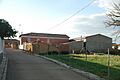
View of Huertas Street.
-
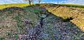
Camino de Vacas. This was the old exit from the village until 1948, when the current local road was laid out. This road used to lead to a wooden pontoon that no longer exists, which crossed the river Valdavia.


Population Changes
| Historical population | ||||||||||||||||||||||||||||||||||||||||||||||||||
|---|---|---|---|---|---|---|---|---|---|---|---|---|---|---|---|---|---|---|---|---|---|---|---|---|---|---|---|---|---|---|---|---|---|---|---|---|---|---|---|---|---|---|---|---|---|---|---|---|---|---|
|
|
|
||||||||||||||||||||||||||||||||||||||||||||||||
See also
 In Spanish: Villamelendro para niños
