Waddon facts for kids
Quick facts for kids Waddon |
|
|---|---|
 Vicarage Road |
|
| Population | 1,679 (2011 Census. Ward) |
| OS grid reference | TQ315645 |
| London borough | |
| Ceremonial county | Greater London |
| Region | |
| Country | England |
| Sovereign state | United Kingdom |
| Post town | CROYDON |
| Postcode district | CR0 |
| Dialling code | 020 |
| Police | Metropolitan |
| Fire | London |
| Ambulance | London |
| EU Parliament | London |
| UK Parliament |
|
| London Assembly |
|
Waddon is a neighbourhood in the London Borough of Croydon. It is located at the western edge of the town of Croydon. The area is also close to the London Borough of Sutton.
Contents
A Look Back in Time
Early Days and Name Origin
Waddon has a very long history. People lived here as far back as the Bronze Age and Iron Age. The name "Waddon" was first written down in the 1100s. It comes from an old English word meaning "the hill where woad grows." Woad is a plant that was used to make blue dye.
Long ago, Waddon was part of the lands owned by the Archbishop of Canterbury. This was around the year 871. The Domesday Book, a famous survey from 1086, shows these lands were used by the Archbishop himself. In the 1200s, Croydon became a market town. This meant people could come to buy and sell goods there.
Homes and Rivers
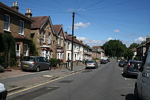
Waddon has some very old houses from the 1800s, and even older ones, near central Croydon. Further south, there is a large area with many homes that were once owned by the local council. Between 1918 and 1939, Waddon had the most council homes in Croydon.
Waddon is located in the valley of the River Wandle. One of the river's starting points, called Waddon Ponds, is a public park. The Wandle river has been uncovered in Wandle Park. This park opened in 1890 and has been improved over the years.
Old Buildings and Industry
The "Hare and Hounds" pub first opened in 1773. It was on a road then called Waddon Marsh Lane. Another old building is the Old Tithe Barn. It was built in 1799 and was once part of a farm. Today, it is used for religious gatherings.
Waddon has a long history of factories and businesses. In 1867, a gasworks was built here. An electricity power station opened in 1896. When the Purley Way road opened in 1925, many factories were built. These included companies making cars, aircraft parts, and even the drink Tizer. A second power station, Croydon B, opened in 1950.
Community and Green Spaces
The Elis David Almshouses were built in 1974. These are special homes for people who need help. They replaced older almshouses from the 1400s.
Duppas Hill was Croydon's first public park. The local health board bought the land in 1865. Bricks for the famous Whitgift almshouses were made from clay found at Duppas Hill.
In 1931, Whitgift School moved to its current location in Haling Park. This park was once home to Lord Howard of Effingham. He was the admiral who led the fleet against the Spanish Armada.
St George's Church was built in 1932. It is located in the middle of the Waddon housing area.
Croydon Airport and World War II
The former Croydon Airport is in Waddon. It started in 1915 to help defend London. In 1920, it became London's main airport for international flights.
The famous international distress call "Mayday" was actually created at Croydon Airport. A radio officer named Frederick Stanley Mockford came up with it.
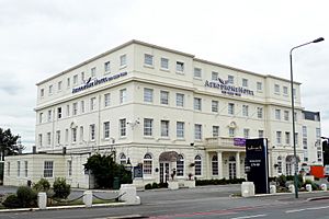
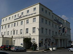
During World War II, Waddon was bombed in 1940. This attack caused many civilian deaths and injuries outside the airport. The airport stopped commercial flights in 1959. The large hotel that used to serve the airport is still there today.
The South London Pirates baseball team plays at Roundshaw. This area is part of the old airport site.
Purley Way and Leisure
A Major Road
The Purley Way is a big road, the A23, that runs through Waddon. It has many large shops and light industrial buildings. This bypass road was first planned in 1908. Work started after World War I in 1919, and it officially opened in 1925. In 1932, the Purley Way was the first road to use sodium street lighting.
Shopping and Fun
The Purley Way is home to the Waddon Leisure Centre. It has a gym, a swimming pool, a learner pool, and a sports hall. This new centre was built where an old pub, "The Propeller Inn," used to be. That pub was popular with RAF pilots during the war.
Waddon used to have other swimming pools on the Purley Way. The open-air Purley Way Swimming Pool opened in 1935 and closed in 1975. A "Water Palace" with wave machines opened in 1990. However, it closed in 1996 because it was losing a lot of money. The site of the Water Palace is now the Colonnades shopping centre.
Getting Around Waddon
Waddon railway station is on the train line that connects to West Croydon and Epsom Downs. The station opened in 1863. There are also Tramlink stops at Waddon Marsh and Wandle Park. The tram system opened in 2000. It made it much easier to travel to Croydon.
Near the original Waddon train station, the Waddon Hotel was built. In 1928, a row of shops called Stafford Parade was completed. It had a dairy, a grocery store, a chemist's, a butcher's, a café, and two banks.
Today, a new primary school is located where the Victoria House building used to be. This school follows a Hindu faith.
Nearby Places
Nearest Stations
- Waddon railway station
- South Croydon railway station
- West Croydon station
- Waddon Marsh tram stop
- Wandle Park tram stop
 | Dorothy Vaughan |
 | Charles Henry Turner |
 | Hildrus Poindexter |
 | Henry Cecil McBay |


