Wales, Wisconsin facts for kids
Quick facts for kids
Wales, Wisconsin
|
|
|---|---|
|
Village
|
|

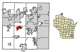
Location of Wales in Waukesha County, Wisconsin.
|
|
| Country | |
| State | |
| County | Waukesha |
| Area | |
| • Total | 3.23 sq mi (8.37 km2) |
| • Land | 3.23 sq mi (8.36 km2) |
| • Water | 0.01 sq mi (0.01 km2) |
| Elevation | 1,001 ft (305 m) |
| Population
(2020)
|
|
| • Total | 2,862 |
| • Density | 801.30/sq mi (309.39/km2) |
| Time zone | UTC-6 (Central (CST)) |
| • Summer (DST) | UTC-5 (CDT) |
| ZIP Code |
53183
|
| Area code(s) | 262 |
| FIPS code | 55-83175 |
| GNIS feature ID | 1576156 |
Wales is a small village located in Waukesha County, Wisconsin. It was first settled by people who came from Wales. In 2020, about 2,862 people lived there.
Contents
Where is Wales, Wisconsin?
Wales is found at specific coordinates on a map. It's about 28 miles (45 km) west of a bigger city called Milwaukee.
The village is also a few miles south of Lapham Peak State Forest. This forest is known for its many hiking trails. It also has the highest point in Waukesha County, which is 1,233 feet (376 meters) above sea level.
According to official records, the village covers a total area of about 3.29 square miles (8.52 square kilometers). Most of this area, about 3.28 square miles (8.50 square kilometers), is land. A very small part, about 0.01 square miles (0.03 square kilometers), is water.
How Many People Live in Wales?
| Historical population | |||
|---|---|---|---|
| Census | Pop. | %± | |
| 1930 | 132 | — | |
| 1940 | 170 | 28.8% | |
| 1950 | 237 | 39.4% | |
| 1960 | 356 | 50.2% | |
| 1970 | 691 | 94.1% | |
| 1980 | 1,992 | 188.3% | |
| 1990 | 2,471 | 24.0% | |
| 2000 | 2,523 | 2.1% | |
| 2010 | 2,549 | 1.0% | |
| 2020 | 2,862 | 12.3% | |
| U.S. Decennial Census | |||
Population in 2010
In 2010, a census counted 2,549 people living in Wales. These people lived in 949 households, and 792 of these were families. The village had about 777 people per square mile (300 people per square kilometer).
Most people in Wales were White (97.9%). Smaller groups included African American (0.4%), Native American (0.2%), and Asian (0.5%). About 1.8% of the population was Hispanic or Latino.
About 37.7% of households had children under 18 living there. Most households (68.5%) were married couples. The average household had 2.69 people. The average family had 2.93 people.
The average age of people in Wales was 43.1 years. About 25.8% of residents were under 18. Also, 9.8% were 65 years old or older. The population was almost evenly split between males (50.3%) and females (49.7%).
Schools in Wales
Wales is part of the Kettle Moraine School District. This district has several schools:
- Kettle Moraine High School: This school is recognized as a Blue Ribbon School.
- Kettle Moraine High School also has four charter schools on its campus. These include the High School of Health Sciences, KM Perform, KM Global, and KM Connect.
- Wales Elementary School: This school also has a charter school on its campus called KM Explore.
Fun Things to Do in Wales
There are several places for recreation and outdoor activities in Wales:
- Glacial Drumlin State Trail: A popular trail for walking and biking.
- Ice Age National Scenic Trail: A long trail that follows features left by glaciers.
- Wales Community Park: A local park for everyone to enjoy.
- Wales Firemans' Park: Another community park.
- Breconshire Park: A park named after a place in Wales.
Places to Worship
Wales has several churches for different faiths:
- Jerusalem Presbyterian Church
- All Saints Lutheran Church
- Bethlehem Lutheran Church
- The Church of Jesus Christ of Latter Day Saints
History of Wales Village
The village of Wales was settled in 1840 by immigrants from Wales. You can still see signs of this Welsh history today. For example, the village's flag looks like the Welsh national flag.
See also
 In Spanish: Wales (Wisconsin) para niños
 | Janet Taylor Pickett |
 | Synthia Saint James |
 | Howardena Pindell |
 | Faith Ringgold |

