
Wallaville facts for kids
Quick facts for kids WallavilleQueensland |
|||||||||||||||
|---|---|---|---|---|---|---|---|---|---|---|---|---|---|---|---|

Wallaville Hotel
|
|||||||||||||||

Wallaville
Location in Queensland
|
|||||||||||||||
| Population | 363 (2021 census) | ||||||||||||||
| • Density | 5.593/km2 (14.49/sq mi) | ||||||||||||||
| Postcode(s) | 4671 | ||||||||||||||
| Area | 64.9 km2 (25.1 sq mi) | ||||||||||||||
| Time zone | AEST (UTC+10:00) | ||||||||||||||
| Location | |||||||||||||||
| LGA(s) | Bundaberg Region | ||||||||||||||
| State electorate(s) | Callide | ||||||||||||||
| Federal Division(s) | Flynn | ||||||||||||||
|
|||||||||||||||
Wallaville is a small town in the countryside of Queensland, Australia. It is part of the Bundaberg Region. Wallaville is about 372 kilometers (231 miles) north of Brisbane, the state capital. It is also 43 kilometers (27 miles) southwest of Bundaberg, a larger regional town. In 2021, about 363 people lived in Wallaville.
Contents
Geography
A creek called Currajong Creek flows through Wallaville. It then joins the Burnett River, which forms most of the eastern edge of the town area. The Burnett River is famous for its lung fish, also known as Ceratodus. Many of these special fish live in the creek.
The main road, called the Bruce Highway, goes right through Wallaville. It runs from the south to the north.
History
Wallaville has a long history, especially with schools and sugar.
Early Schools
The first school in the area was Walla Provisional School, which opened around 1883. It closed about ten years later. Another school, Currajong Creek Provisional School, started in 1884. It changed its name to Cumonju State School in 1909 and closed in 1967. Ferry Hills Provisional School opened in 1904 and became Ferry Hills State School in 1909. It closed in 1956. Wallaville State School, which is still open today, began in 1909. It celebrated its 100th birthday in November 2009.
The Sugar Mill and Railway
In 1896, the Gin Gin co-operative sugar mill opened in Wallaville. This mill was very important for the town. During the sugar cane harvesting season, from July to December, the town's population would double. Many workers and cane cutters came to Wallaville for the sugar industry.
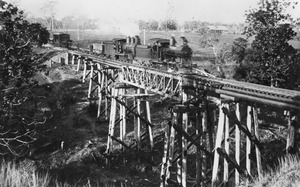
In 1920, a railway line was built to Wallaville. It connected the town to other railway lines, helping to transport sugar cane and timber.
Bridges Over the Burnett River
In 1929, a bridge that was originally for cane trains was changed so cars could use it. This bridge crossed the Burnett River. It was very helpful because it allowed people to travel between Brisbane and Rockhampton without going through Bundaberg. This saved about 80 miles (129 kilometers) on the trip.
However, keeping the bridge in good shape was expensive. Local volunteers struggled to pay for its upkeep. Eventually, in 1940, a new concrete bridge was built. This new bridge was 690 feet (210 meters) long.

In the 1950s, a new sugar terminal was built. Sugar was then moved by road instead of by train. This led to the railway line closing in 1964. The railway tracks were sold to the sugar mill to build smaller tracks for cane trains around Wallaville. The sugar mill itself closed in 1974. However, sugar cane continued to be transported from Wallaville by connecting its cane train network to other sugar mill areas.
The Tim Fischer Bridge
In the 1990s, a new plan for the Burnett River was made. It involved building a weir (a type of dam) downstream from the Wallaville Bridge. The old bridge was low, so it often closed when the river flooded. The new weir would make the river higher, causing even more floods and damage to the old bridge.
So, it was decided to build a new, higher bridge about 5 kilometers (3 miles) upstream. Construction started in 1997. On July 5, 1999, the new bridge was opened by the Deputy Prime Minister, Tim Fischer. It was named the Tim Fischer Bridge in his honor. This new bridge and the road leading to it cost $28 million.
Population
In 2021, the population of Wallaville was 363 people.
Education
Wallaville State School is a primary school for students from Prep to Year 6. It is located at 7 Grey Street. In 2017, the school had 62 students.
There is no high school in Wallaville. The closest high school is in Gin Gin.
Facilities
Wallaville has several useful places for its residents. You can find two general stores, a bakery, and a butcher shop. There is also a post office and a garage. The town also has the Bellevue Hotel. The Wallaville Hall is a community building located at 2 Walla Street.
