Walthall County, Mississippi facts for kids
Quick facts for kids
Walthall County
|
|
|---|---|

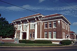
Walthall County courthouse in Tylertown
|
|

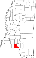
Location within the U.S. state of Mississippi
|
|
 Mississippi's location within the U.S. |
|
| Country | |
| State | |
| Founded | 1910 |
| Named for | Edward C. Walthall |
| Seat | Tylertown |
| Largest town | Tylertown |
| Area | |
| • Total | 404 sq mi (1,050 km2) |
| • Land | 404 sq mi (1,050 km2) |
| • Water | 0.5 sq mi (1 km2) 0.1% |
| Population
(2020)
|
|
| • Total | 13,884 |
| • Density | 34.37/sq mi (13.269/km2) |
| Time zone | UTC−6 (Central) |
| • Summer (DST) | UTC−5 (CDT) |
| Congressional district | 3rd |
Walthall County is a place in the state of Mississippi, USA. It's like a smaller region within the state. In 2020, about 13,884 people lived there. The main town, or "county seat," is Tylertown. The county got its name from Edward C. Walthall. He was a general during the American Civil War and later a senator for Mississippi.
Contents
About Walthall County
Walthall County was created in 1910. It is located in the southwestern part of Mississippi. The county is named after Edward C. Walthall, who was an important figure in Mississippi's history.
Where is Walthall County?
Walthall County is in the southwest part of Mississippi. It is one of the smaller counties in the state. Most of its area is land, with only a tiny bit of water.
Nearby Counties
Walthall County shares its borders with several other counties:
- Lawrence County to the north
- Marion County to the east
- Washington Parish in Louisiana to the south
- Pike County to the west
- Lincoln County to the northwest
Main Roads
These are the important roads that go through Walthall County:
Who Lives Here?
According to the 2020 census, 13,884 people live in Walthall County. Most people are either White or Black or African American. There are also smaller groups of Native American, Asian, and other backgrounds. Some people identify as Hispanic or Latino.
| Historical population | |||
|---|---|---|---|
| Census | Pop. | %± | |
| 1920 | 13,455 | — | |
| 1930 | 13,871 | 3.1% | |
| 1940 | 17,534 | 26.4% | |
| 1950 | 15,563 | −11.2% | |
| 1960 | 13,512 | −13.2% | |
| 1970 | 12,500 | −7.5% | |
| 1980 | 13,761 | 10.1% | |
| 1990 | 14,352 | 4.3% | |
| 2000 | 15,156 | 5.6% | |
| 2010 | 15,443 | 1.9% | |
| 2020 | 13,884 | −10.1% | |
| 2023 (est.) | 13,863 | −10.2% | |
| U.S. Decennial Census 1790-1960 1900-1990 1990-2000 2010-2013 |
|||
Towns and Communities
The main town in Walthall County is Tylertown. It is the county seat, which means it's where the county government is located.
Town
- Tylertown (county seat)
Other Communities
There are also several smaller, unincorporated communities in the county. These are places that don't have their own local government.
- Darbun
- Dexter
- Little Improve
- Mesa
- Salem
- Sartinville
- Union
- Hope
- Dillon
- Kirklin
Education in Walthall County
Students in Walthall County attend schools run by the Walthall County School District. For higher education, the county is part of the district for Southwest Mississippi Community College.
Images for kids
See also
 In Spanish: Condado de Walthall para niños
 | Frances Mary Albrier |
 | Whitney Young |
 | Muhammad Ali |


