Pike County, Mississippi facts for kids
Quick facts for kids
Pike County
|
|
|---|---|

|
|

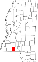
Location within the U.S. state of Mississippi
|
|
 Mississippi's location within the U.S. |
|
| Country | |
| State | |
| Founded | 1815 |
| Named for | Zebulon Pike |
| Seat | Magnolia |
| Largest city | McComb |
| Area | |
| • Total | 411 sq mi (1,060 km2) |
| • Land | 409 sq mi (1,060 km2) |
| • Water | 1.7 sq mi (4 km2) 0.4% |
| Population
(2020)
|
|
| • Total | 40,324 |
| • Density | 98.11/sq mi (37.88/km2) |
| Time zone | UTC−6 (Central) |
| • Summer (DST) | UTC−5 (CDT) |
| Congressional district | 3rd |
Pike County is a county located in the southwestern part of Mississippi, a state in the United States. It sits right on the border with Louisiana. In 2020, about 40,324 people lived here.
The main town, also called the county seat, is Magnolia. Pike County got its name from a famous explorer named Zebulon Pike. This county is also part of the McComb area, which is a group of towns and cities that are connected by their economy.
Contents
A Look at Pike County's Past
Pike County was created on December 9, 1815. It was formed from a part of Marion County by a decision of the government at that time.
The first county seat was a town called Holmesville. It was chosen on December 11, 1816, and named after a brave army officer, Major Andrew Hunter Holmes. Later, in 1873, the people voted to make Magnolia the new county seat. For a long time, Pike County was mainly a farming area, and it still has many rural, open spaces today.
Where is Pike County?
Pike County covers a total area of about 411 square miles. Most of this area, about 409 square miles, is land. The rest, about 1.7 square miles, is water, which is less than half a percent of the total area.
Main Roads in Pike County
These are the most important roads that run through Pike County:
 Interstate 55
 U.S. Highway 51
 U.S. Highway 98
 Mississippi Highway 24
 Mississippi Highway 44
 Mississippi Highway 48
 Mississippi Highway 570
 Mississippi Highway 583
Neighboring Counties and Parishes
Pike County shares its borders with these other counties and parishes:
- To the north: Lincoln County
- To the east: Walthall County
- To the southeast: Washington Parish, Louisiana (a parish is like a county in Louisiana)
- To the south: Tangipahoa Parish, Louisiana
- To the west: Amite County
People of Pike County
In 2020, there were 40,324 people living in Pike County. There were 14,404 households, which are groups of people living together, and 8,528 families.
| Group | Number of People | Percentage |
|---|---|---|
| White | 16,769 | 41.59% |
| Black or African American | 21,457 | 53.21% |
| Native American | 113 | 0.28% |
| Asian | 254 | 0.63% |
| Pacific Islander | 7 | 0.02% |
| Other/Mixed | 1,097 | 2.72% |
| Hispanic or Latino | 627 | 1.55% |
Towns and Communities
Pike County has several different types of communities:
Cities
Towns
Census-designated Place
- Fernwood (This is a special area that is like a town for counting purposes, but it doesn't have its own local government.)
Unincorporated Communities
These are smaller communities that are not officially part of a city or town:
Schools and Learning
Pike County has three main school districts that manage the public schools:
- McComb School District
- North Pike School District
- South Pike School District
For students who want to continue their education after high school, Pike County is also served by Southwest Mississippi Community College.
Images for kids
See also
 In Spanish: Condado de Pike (Misisipi) para niños
 | John T. Biggers |
 | Thomas Blackshear |
 | Mark Bradford |
 | Beverly Buchanan |


