Wartrace, Tennessee facts for kids
Quick facts for kids
Wartrace
|
|
|---|---|

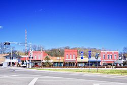
Downtown Wartrace
|
|
| Nickname(s):
The Cradle of the Walking Horse
|
|

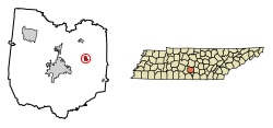
Location of Wartrace in Bedford County, Tennessee.
|
|
| Country | United States |
| State | Tennessee |
| County | Bedford |
| Incorporated | 1858 |
| Named for | Indian trail that passed through the area |
| Area | |
| • Total | 0.88 sq mi (2.27 km2) |
| • Land | 0.88 sq mi (2.27 km2) |
| • Water | 0.00 sq mi (0.00 km2) |
| Elevation | 833 ft (254 m) |
| Population
(2020)
|
|
| • Total | 653 |
| • Density | 745.43/sq mi (287.78/km2) |
| Time zone | UTC-6 (Central (CST)) |
| • Summer (DST) | UTC-5 (CDT) |
| ZIP code |
37183
|
| Area code(s) | 931 |
| FIPS code | 47-78120 |
| GNIS feature ID | 1304389 |
Wartrace is a small town in Bedford County, Tennessee. In 2020, about 653 people lived there. It is located northeast of Shelbyville. The town's center is very old and special. It is listed on the National Register of Historic Places as the Wartrace Historic District.
Wartrace is famous for the Tennessee Walking Horse. It is even called "the cradle of the Tennessee Walking Horse." The town hosts the Wartrace Horse Show every year since 1906. The Tennessee Walking Horse National Museum has been in downtown Wartrace since 2012.
Contents
History of Wartrace
How Wartrace Got Its Name
The name "Wartrace" comes from an old Native American trail. This trail used to pass right through the area where the town is now.
Early Days and the Railroad
The town started in the early 1850s. It was first known as "Wartrace Depot." This was because it became a stop on the new Nashville and Chattanooga Railroad.
Wartrace During the Civil War
During the American Civil War, Wartrace was important for the Confederate army. General William J. Hardee made it his winter home after the Battle of Stones River. The Old Chockley Tavern in Wartrace was a meeting spot for Confederate officers. A small fight also happened here on April 11, 1862.
Growth and the Horse Industry
As more people traveled by train in the late 1800s, Wartrace grew a lot. At its busiest, the town had six hotels and inns. About 13 trains stopped there every day. One of these old hotels, the Walking Horse Hotel, is still open today.
In the early 1900s, Wartrace became a key place for breeding the Tennessee Walking Horse. This is why the Wartrace Horse Show was started in the town. Wartrace is still connected to Shelbyville by the Walking Horse and Eastern Railroad. This historic train line still runs sometimes.
Local Schools and Achievements
In 1972, Cascade K-5 school opened. This happened after a fire at Bell Buckle School. Students from nearby towns like Bell Buckle, Tennessee, Shelbyville, Tennessee, and Wartrace went there. Cascade Middle & High School has many activities. These include a football team, a drama club, and a marching band. In 2012, the Cascade High School Marching Band won a state championship!
Geography and Climate
Where is Wartrace Located?
Wartrace is located at 35°31′37″N 86°19′51″W / 35.52694°N 86.33083°W. The town covers about 0.7 square miles (1.8 square kilometers) of land. There is no water area within the town limits.
Wartrace Weather
Wartrace has a warm and humid climate. This means it has relatively high temperatures. It also gets rain spread out evenly throughout the year. This type of climate is called a "Humid Subtropical Climate."
| Climate data for Wartrace, TN | |||||||||||||
|---|---|---|---|---|---|---|---|---|---|---|---|---|---|
| Month | Jan | Feb | Mar | Apr | May | Jun | Jul | Aug | Sep | Oct | Nov | Dec | Year |
| Mean daily maximum °C (°F) | 9 (49) |
12 (53) |
17 (62) |
22 (72) |
27 (80) |
31 (87) |
32 (90) |
32 (89) |
29 (84) |
23 (73) |
16 (61) |
11 (52) |
22 (71) |
| Mean daily minimum °C (°F) | −2 (28) |
−1 (31) |
3 (38) |
8 (47) |
13 (55) |
17 (63) |
19 (67) |
19 (66) |
15 (59) |
8 (47) |
3 (38) |
−1 (31) |
8 (47) |
| Average precipitation mm (inches) | 120 (4.9) |
120 (4.6) |
150 (5.8) |
110 (4.5) |
130 (5.3) |
110 (4.2) |
120 (4.7) |
94 (3.7) |
100 (4) |
86 (3.4) |
120 (4.6) |
130 (5.2) |
1,400 (55) |
| Average precipitation days | 11 | 11 | 11 | 10 | 10 | 10 | 10 | 8 | 8 | 7 | 9 | 11 | 116 |
| Source: Weatherbase | |||||||||||||
People of Wartrace
Population Changes Over Time
| Historical population | |||
|---|---|---|---|
| Census | Pop. | %± | |
| 1880 | 468 | — | |
| 1890 | 686 | 46.6% | |
| 1900 | 642 | −6.4% | |
| 1910 | 659 | 2.6% | |
| 1920 | 619 | −6.1% | |
| 1930 | 606 | −2.1% | |
| 1940 | 552 | −8.9% | |
| 1950 | 545 | −1.3% | |
| 1960 | 545 | 0.0% | |
| 1970 | 616 | 13.0% | |
| 1980 | 540 | −12.3% | |
| 1990 | 494 | −8.5% | |
| 2000 | 548 | 10.9% | |
| 2010 | 651 | 18.8% | |
| 2020 | 653 | 0.3% | |
| Sources: | |||
In 2000, there were 548 people living in Wartrace. These people lived in 234 households. Most people (88.14%) were White. About 8.94% were African American. A small number of people were from other backgrounds.
Household Information
About 30.3% of households had children under 18. Many households (48.3%) were married couples. About 33.8% of households had only one person living there. The average household had 2.34 people.
Age and Income
The median age in Wartrace was 38 years old. This means half the people were younger than 38 and half were older. About 25.7% of the population was under 18. The median income for a household was $29,500. This means half of the households earned more and half earned less. About 14.2% of the population lived below the poverty line.
Notable Person from Wartrace
- Sondra Locke (1944–2018), was an actress who was nominated for an Academy Award. She used to live on Horse Mountain Road in Wartrace.
See also
 In Spanish: Wartrace para niños

