
Watauga Dam facts for kids
Quick facts for kids Watauga Dam |
|
|---|---|

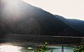
Watauga Dam (from upstream), June, 2008
|
|
| Official name | Watauga Dam |
| Location | Carter County, Tennessee, United States |
| Coordinates | 36°19′24″N 82°7′19″W / 36.32333°N 82.12194°W |
| Construction began | February 16, 1942 |
| Opening date | December 1, 1948 |
| Operator(s) | Tennessee Valley Authority |
| Dam and spillways | |
| Impounds | Watauga River |
| Height | 318 feet (97 m) |
| Length | 900 feet (270 m) |
| Reservoir | |
| Creates | Watauga Lake |
| Total capacity | 677,000 acre⋅ft (835,000 dam3) |
The Watauga Dam is a huge structure built on the Watauga River in Carter County, Tennessee. It helps create electricity using water power (this is called hydroelectric power) and also stops floods. The dam is owned and run by the Tennessee Valley Authority (TVA). They built it in the 1940s to help control water levels in the Tennessee River area.
Watauga Dam is 318 feet (97 m) tall. This makes it the second-tallest dam in the whole TVA system! Only Fontana Dam is taller. When it was finished, Watauga Dam was one of the tallest dams made of earth and rock in the United States. The dam holds back water to form Watauga Lake, which covers about 6,430 acres (2,600 ha). The water flowing out of the dam goes into Wilbur Lake. A famous hiking path, the Appalachian Trail, even crosses the top of Watauga Dam!
The dam gets its name from the Watauga River. The river was named after an old Cherokee village called Watauga Old Fields. This village was once located near where Elizabethton is today. Watauga Dam was added to the National Register of Historic Places on August 11, 2017, which means it's an important historical site.
Where is Watauga Dam Located?
Watauga Dam is about 37 miles (60 km) up the Watauga River from where it joins another river. It's built where the river, which usually flows west, turns north to cut through a mountain called Iron Mountain. The dam is about 5 miles (8.0 km) downstream from the town of Butler, Tennessee and 10 miles (16 km) upstream from Elizabethton.
Watauga Lake stretches for about 16.7 miles (26.9 km) along the river. It almost reaches the border between Tennessee and North Carolina. The lake is in both Carter County and Johnson County in Tennessee. Several creeks and rivers, like Roan Creek, Cobb Creek, and the Elk River, flow into the lake, creating large bays.
How Watauga Dam Works
Watauga Dam is made of earth and rock. It stands 318 feet (97 m) high and is 900 feet (270 m) long. The dam can produce 57,600 kilowatts of electricity. It has a special overflow area called a "morning glory" spillway. This spillway can release a maximum of 73,200 cubic feet per second (2,070 m3/s) of water if the lake gets too full.
Watauga Lake has 106 miles (171 km) of shoreline, which is like the edge of the lake. It can hold a huge amount of water, about 677,000 acre⋅ft (835,000 dam3). A big part of this water, 152,829 acre⋅ft (188,512 dam3), is kept just for flood control. This means they can release water slowly to prevent flooding downstream. The lake's water level usually changes by about 9 feet (2.7 m) in a typical year.
The power plant that makes electricity is located almost a mile downstream from the dam. A long tunnel, 3,700-foot (1,100 m) long, connects the lake's water intake to the power plant. Closer to the power plant, this tunnel splits into two steel pipes. These pipes carry the water to a valve house right before the water spins the turbines to make electricity.
Building Watauga Dam

People knew the Watauga River could be used to make electricity since the early 1900s. Back then, the Watauga Power Company built Wilbur Dam about 3 miles (4.8 km) downstream from where Watauga Dam is now. In the 1920s, another company planned to build large dams in the South Fork Holston River area. They found two good spots for dams on the Watauga River. One of these spots was where Watauga Dam stands today, which they called "Cardens Bluff."
In the early 1940s, the Tennessee Valley Authority (TVA) took over managing flood control in the Tennessee River area. They suggested building a dam at the Cardens Bluff site. This dam was needed to store water and help prevent floods. It was also important for providing more electricity during World War II. Many local people supported the dam project, especially in Elizabethton, which had suffered a bad flood in 1940. The Watauga project was approved on December 17, 1941. Work on the dam began soon after, on February 16, 1942.

Building Watauga Dam and its lake meant buying 11,700 acres (47 km2) of land. About 1,663 acres (6.7 km2) of this land had to be cleared of trees and plants. Many people had to move: 761 families were relocated, and 1,281 graves were moved. Also, 55 miles (89 km) of roads had to be rebuilt, and three new bridges were constructed. Even Wilbur Dam, which was just 3 miles (4.8 km) downstream, had to be made taller and given a new spillway. The entire town of Butler had to be moved to a new location!
In October 1942, the U.S. War Production Board told the TVA to stop working on the Watauga project. They felt it wasn't needed for the country's war efforts at that time. The TVA spent several weeks making the dam site safe. The project was then put on hold until the war ended. Construction started again on May 22, 1946.
Watauga Dam was finally finished, and its gates were opened on December 1, 1948. The first generator started making electricity on August 30, 1949. The second one began on September 29, 1949. The total cost to build the Watauga project was a little over $32 million.
Images for kids
-
Watauga Dam (from upstream), June, 2008
